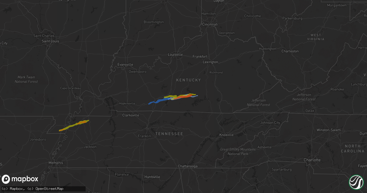
Hail Map on December 31, 2021
Get this storm
December 31 map
$229
one time, instant access
Download today. No call, no setup
Keep the $229
Bought the map and want the full workflow? Apply the entire $229 to a subscription within 7 days. None of it is wasted.
Every map, not just this one
This buys you this map. Subscription and you get every map we run, in the markets you choose from a few cities to whole states to nationwide. Plus real-time alerts the moment a storm fires.
Contact data
Name, contact info, occupancy, even credit band for addresses in the footprint. You go from where it hit to who to call.
Become the source they trust
Unlimited branding weather history reports on demand. You already have the documented answer ready for the property owner, and you are the one who showed up with it.
Property data and RoofTrace estimates
Pull up any address you have got, its value and the exact code rules for that jurisdiction, straight from One Click Code. Then RoofTrace estimates the squares, pitch, and roof value, priced the way you price.
Storm reports
Oklahoma
| Date | Description |
|---|---|
| 12/31/20214:21 AM CST | At 1021 PM CST, a severe thunderstorm was located 5 miles east of Oleta, moving northeast at 40 mph. HAZARD...60 mph wind gusts and quarter size hail. SOURCE...Radar indicated. IMPACT...Hail damage to vehicles is expected. Expect wind damage to roofs, siding, and trees. Locations in or near the path include... Oleta... Cloudy... Corinne... Sobol... |
Kentucky
| Date | Description |
|---|---|
| 12/31/20215:17 AM CST | A local report indicates 1.50 inch wind near 4 ENE GASCON |
North Carolina
| Date | Description |
|---|---|
| 12/31/20215:48 AM CST | At 1147 PM EST, a severe thunderstorm was located 8 miles north of Rockingham, moving east at 20 mph. HAZARD...60 mph wind gusts. SOURCE...Radar indicated. IMPACT...Expect damage to roofs, siding, and trees. Locations impacted include... Southern Pines, Rockingham, Pinehurst, Aberdeen, Hoffman, Whispering Pines, Pinebluff, Ellerbe, Foxfire and Taylortown. |
Alabama
| Date | Description |
|---|---|
| 12/31/20212:50 PM CST | Corrects previous tstm wnd dmg report from 5 ene collinsville. Mobile home thrown from foundation. Possible tornado. |
| 12/31/20212:50 PM CST | Mobile thrown from foundation. Possible tornado. |
| 12/31/20212:50 PM CST | Two chicken houses had roofs removed... And trees snapped 15-20 feet off ground. Telephone pole also snapped. Possible tornado. |
Missouri
| Date | Description |
|---|---|
| 12/31/202112:26 AM CST | A local report indicates 1.50 inch wind near 2 S HOLLAND |
Tennessee
| Date | Description |
|---|---|
| 12/31/202112:58 AM CST | Tree knocked down on cat corner road. |
Georgia
| Date | Description |
|---|---|
| 12/31/20214:41 PM CST | Carroll county emergency management reported numerous trees blown down along cown road between long branch road and van wert road. At least one tree fell onto a home. |
| 12/31/20214:35 PM CST | Substantial damage occured in western covington near the intersection of brown bridge rd and salem rd. Structural damage was observed at veterans middle school and at a |
| 12/30/20217:46 PM CST | At 146 AM EST, a severe thunderstorm was located over Broxton, moving east at 30 mph. HAZARD...60 mph wind gusts. SOURCE...Radar indicated. IMPACT...Expect damage to roofs, siding, and trees. Locations impacted include... Broxton and Ambrose. |
| 12/30/20217:25 PM CST | At 125 AM EST, a severe thunderstorm was located near Ambrose, moving east at 20 mph. HAZARD...60 mph wind gusts. SOURCE...Radar indicated. IMPACT...Expect damage to roofs, siding, and trees. Locations impacted include... Wray and Osierfield. |
Cities Impacted by Hail Map on December 31, 2021
- Park City, KY
- Edmonton, KY
- Horse Cave, KY
- Glasgow, KY
- Cave City, KY
- Knob Lick, KY
- Smiths Grove, KY
- Gradyville, KY
- Russell Springs, KY
- Columbia, KY
- Covington, GA
- Social Circle, GA
- Conyers, GA
- Villa Rica, GA
- Temple, GA
- Auburn, KY
- Rockfield, KY
- Woodburn, KY
- Oakland, KY
- Bowling Green, KY
- Alvaton, KY
- Obion, TN
- Caruthersville, MO
- Troy, TN
- Rives, TN
- Steele, MO
- Ridgely, TN
- Union City, TN
- Hornbeak, TN
- Martin, TN