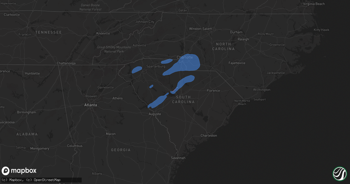
Hail Map on December 29, 2024
Get this storm
December 29 map
$229
one time, instant access
Download today. No call, no setup
Keep the $229
Bought the map and want the full workflow? Apply the entire $229 to a subscription within 7 days. None of it is wasted.
Every map, not just this one
This buys you this map. Subscription and you get every map we run, in the markets you choose from a few cities to whole states to nationwide. Plus real-time alerts the moment a storm fires.
Contact data
Name, contact info, occupancy, even credit band for addresses in the footprint. You go from where it hit to who to call.
Become the source they trust
Unlimited branding weather history reports on demand. You already have the documented answer ready for the property owner, and you are the one who showed up with it.
Property data and RoofTrace estimates
Pull up any address you have got, its value and the exact code rules for that jurisdiction, straight from One Click Code. Then RoofTrace estimates the squares, pitch, and roof value, priced the way you price.
States Impacted by Hail Map on December 29, 2024
Storm reports
Georgia
| Date | Description |
|---|---|
| 12/29/20245:29 PM CST | Multiple trees down on the north side of carrollton. |
| 12/29/20246:30 AM CST | Report of trees down at the intersection of highway 24 and bailey road. Time estimated from radar. |
| 12/29/20246:30 AM CST | Broadcast media forwarded reports of tree damage near the intersection of 223 and 221. Time estimated by radar. |
| 12/29/20242:54 AM CST | An ef 1 tornado touched down near the durand community and continued to track ne across meriweather county before lifting just south of the coweta county line near sull |
South Carolina
| Date | Description |
|---|---|
| 12/29/20249:01 AM CST | Sc highway patrol reported trees down near i20 and route 15. |
| 12/29/20248:29 AM CST | Reports from lancaster emergency management of multiple trees down across lancaster/kershaw county line through rich hill area. Time estimated by radar. |
| 12/29/20248:28 AM CST | Kershaw dispatch received reports of several trees down around lugoff. Time estimated by radar. |
| 12/29/20248:16 AM CST | Report from mping: trees uprooted or snapped; roof blown off. |
| 12/29/20248:09 AM CST | Report from mping: 1-inch tree limbs broken; shingles blown off. |
| 12/29/20248:02 AM CST | Report from mping: 1-inch tree limbs broken; shingles blown off. |
| 12/29/20248:01 AM CST | Scdps website reported power lines in the roadway in downtown ridgeway near the intersection of longtown road and palmer street. Time estimated by radar. |
| 12/29/20248:00 AM CST | Scemd employee relayed information from fairfield county dispatch of multiple closed roads due to downed trees. Specifically... Trees are down around 303 palmetto avenu |
| 12/29/20247:56 AM CST | A national weather service storm survey team determined that an ef-1 tornado... With peak wind speeds of 95 mph... Occurred just south of winnsboro. The tornado began j |
| 12/29/20247:56 AM CST | State employee relayed pictures of possible tornado damage near the mlily plant around the intersection of highway 321... Industrial park road... And bulldog blvd. Time |
| 12/29/20247:56 AM CST | Trained spotter relayed a report of highway 34 shut down and power lines on the road in the simpson community. Time estimated by radar. Location also estimated. |
| 12/29/20247:56 AM CST | Trained spotter relayed a report of 3 blown transformers and power lines on the road near palmetto imaging in winnsboro. Time estimated by radar. |
| 12/29/20247:55 AM CST | 911 center reports numerous trees down all over the county. |
| 12/29/20247:53 AM CST | Scdps site reported a tree in roadway at the intersection of highway 269... Mockingbird lane... And weldon road. Time estimated by radar. |
| 12/29/20247:52 AM CST | A national weather service storm survey team determined that a weak ef-0 tornado... With peak wind speeds of 80 mph... Occurred just south of rion. The tornado began ne |
| 12/29/20247:50 AM CST | Trees down scattered across the county. |
| 12/29/20247:44 AM CST | Scdps website reported a tree in roadway on state highway 215. Time estimated by radar. |
| 12/29/20247:39 AM CST | Public reported through social media multiple trees down on muddy ford rd. Time estimated by radar. |
| 12/29/20247:39 AM CST | Scdps site reported a tree in roadway at the intersection of parr road and broad river road. Time estimated by radar. |
| 12/29/20247:37 AM CST | Scdps website reported tree in roadway on old hilton road near the intersection of back acres road. Time estimated by radar. |
| 12/29/20247:37 AM CST | Scdps website reported a tree in roadway on three dog road near the intersection of peace heaven road. Time estimated by radar. |
| 12/29/20247:35 AM CST | A national weather service storm survey team determined that a weak ef-0 tornado... With peak wind speeds of 75 mph... Occurred near the spring hill area. A weak but re |
| 12/29/20247:32 AM CST | 911 center reports trees and power lines down across roads in spots mainly to the east and northeast of union. |
| 12/29/20247:15 AM CST | Tree fell on a house. |
| 12/29/20247:00 AM CST | Trees down scattered across the county. |
| 12/29/20246:47 AM CST | Edgefield dispatch received a call about a tree down on penn st. Time estimated by radar. |
| 12/29/20246:45 AM CST | Schp reported tree downed along mountain creek rd. |
| 12/29/20246:40 AM CST | Schp reported tree downed along keeler mill rd. |
| 12/29/20246:39 AM CST | Edgefield dispatch received a call regarding a tree down on key rd. Time estimated by radar. |
| 12/29/20246:39 AM CST | Report of damage to a porch and roofs in the area. Trees also down. |
| 12/29/20246:30 AM CST | Multiple trees down near intersection of cobb road and mantague avenue. |
| 12/29/20246:30 AM CST | Tree down on a house on east creek road. |
| 12/29/20246:30 AM CST | Tree down at oak forest drive and chinquapin road. |
| 12/29/20246:25 AM CST | Schp reported tree downed along concord rd. |
| 12/29/20246:20 AM CST | County comms reported scattered trees downed countywide. |
| 12/29/20246:15 AM CST | Several trees down scattered across the county. |
| 12/29/20246:00 AM CST | Schp reports tree downed on woodburn rd. |
Florida
| Date | Description |
|---|---|
| 12/29/20248:00 AM CST | Two pine trees down at east capps highway and south barber hill road... Blocking traffic lanes. |
| 12/29/20247:30 AM CST | Power line down at 5051 tram road. |
| 12/29/20246:54 AM CST | Tree down on cr 65. |
| 12/29/20246:13 AM CST | Tree down near the intersection of fl state routes 20 and 73. |
| 12/29/20246:12 AM CST | Tree down blocking road at 696 blueberry drive. |
| 12/29/20246:00 AM CST | 2 powerlines down at 71s and laramie st. |
North Carolina
| Date | Description |
|---|---|
| 12/29/202410:25 AM CST | Over 200 power outages reported south of whispering pines... Near the intersection of airport rd and windsong pl. |
| 12/29/202410:17 AM CST | Power outages reported along army rd and fox ln southeast of ashley heights. |
| 12/29/20249:50 AM CST | Randolph county emergency management reports 6 to 8 trees down across the county... With no significant subsequent damage. |
| 12/29/20249:47 AM CST | Report from mping: 1-inch tree limbs broken. |
| 12/29/20249:20 AM CST | Trees and power lines down. |
| 12/29/20249:19 AM CST | Tree down on park drive near its intersection with carter street. Time estimated from radar. |
| 12/29/20249:18 AM CST | Trees down on creekside drive and woodlawn ave. |
| 12/29/20249:15 AM CST | Tree down at intersection of rena road and cheek road. Time estimated from radar. |
| 12/29/20249:09 AM CST | A couple trees downed and blocking cane creek church road in the mcgrady area. Time estimated from radar. |
| 12/29/20249:05 AM CST | Trees down in the southern and southeastern parts of the county. |
| 12/29/20249:03 AM CST | Report from mping: |
| 12/29/20249:03 AM CST | Report from mping: trees uprooted or snapped; roof blown off. |
| 12/29/20248:52 AM CST | Multiple trees and power lines down. |
| 12/29/20248:52 AM CST | Report from mping: 1-inch tree limbs broken; shingles blown off. |
| 12/29/20248:52 AM CST | A few trees down along east brocktown road. Time estimated from radar. |
| 12/29/20248:50 AM CST | Tree down on vehicle on bramley road. |
| 12/29/20248:50 AM CST | Trees down at exit 154 along interstate 40. |
| 12/29/20248:49 AM CST | Multiple trees down between concord and mt. Pleasant along highway 73 and highway 601. |
| 12/29/20248:45 AM CST | Tree blocking vashti cemetary road. |
| 12/29/20248:41 AM CST | Report from mping: 1-inch tree limbs broken; shingles blown off. |
| 12/29/20248:40 AM CST | A local report indicates 61 MPH wind near 5 WNW Monroe |
| 12/29/20248:37 AM CST | Tree down blocking paul payne store road. |
| 12/29/20248:32 AM CST | Report from mping: 3-inch tree limbs broken; power poles broken. |
| 12/29/20248:30 AM CST | Several trees down across the county. |
| 12/29/20248:26 AM CST | Clt asos gusted to 51 knots. |
| 12/29/20248:25 AM CST | Several pieces of sheet metal roofing blown off a barn along 321 in maiden. |
| 12/29/20248:20 AM CST | Report from mping: 1-inch tree limbs broken; shingles blown off. |
| 12/29/20248:20 AM CST | Shingles and flashing blown off a house... Privacy fence blown down and metal flagpole ripped off a porch. |
| 12/29/20248:20 AM CST | A few trees down and a power line down in several locations... Specifically in and near gastonia... Belmont and mt. Holly. |
| 12/29/20248:18 AM CST | Corrects previous tstm wnd dmg report from 1 se mount holly. Trees down on creekside drive and woodlawn ave. |
| 12/29/20248:15 AM CST | Scattered trees down in the county... Especially in the western part. |
| 12/29/20248:09 AM CST | A couple of trees down. |
| 12/29/20248:00 AM CST | Several trees and power lines down around tryon. |
| 12/29/20248:00 AM CST | Several trees down along interstate 85. |
| 12/29/20247:45 AM CST | Scattered trees down across the county... Particularly along highway 226. |
Ohio
| Date | Description |
|---|---|
| 12/29/20244:33 PM CST | Report from mping: 1-inch tree limbs broken; shingles blown off. |
| 12/29/20242:08 PM CST | A weak tornado caused minor structural and tree damage. |
| 12/29/20241:51 PM CST | Video showing a barn door blown into a field. |
| 12/28/20248:53 PM CST | Report from mping: 3-inch tree limbs broken; power poles broken. |
Cities Impacted by Hail Map on December 29, 2024
- Gattman, MS
- Greenwood Springs, MS
- Sulligent, AL
- Detroit, AL
- Kennedy, AL
- Vernon, AL
- Millport, AL
- Fayette, AL
- Eldridge, AL
- Guin, AL
- Winfield, AL
- Beaverton, AL
- Hamilton, AL
- Bear Creek, AL
- Lynn, AL
- Hackleburg, AL
- Haleyville, AL
- Brilliant, AL
- Nauvoo, AL
- Carbon Hill, AL
- Panama City Beach, FL
- Panama City, FL
- Youngstown, FL
- Clarksville, FL
- Altha, FL
- Fountain, FL
- Marianna, FL
- Alford, FL
- Chipley, FL
- Grand Ridge, FL
- Cottondale, FL
- Port Saint Joe, FL
- Wewahitchka, FL
- Bristol, FL
- Lynn Haven, FL
- Hosford, FL
- Blountstown, FL
- Quincy, FL
- Evans, GA
- Modoc, SC
- Clarks Hill, SC
- Appling, GA
- North Augusta, SC
- Augusta, GA
- Edgefield, SC
- Trenton, SC
- Johnston, SC
- Ward, SC
- Saluda, SC
- Ridge Spring, SC
- Batesburg, SC
- Leesville, SC
- Prosperity, SC
- Union, SC
- Sharon, SC
- Lockhart, SC
- Chester, SC
- York, SC
- Jonesville, SC
- McConnells, SC
- Rock Hill, SC
- Hickory Grove, SC
- Fort Mill, SC
- Charlotte, NC
- Clover, SC
- Belmont, NC
- Pineville, NC
- Indian Trail, NC
- Waxhaw, NC
- Matthews, NC
- Monroe, NC
- Chester, IA
- Riceville, IA
- Greenwood, SC
- Hodges, SC
- Waterloo, SC
- Central, SC
- Pickens, SC
- Six Mile, SC
- Norris, SC
- Liberty, SC
- Easley, SC
- Greenville, SC
- Chapin, SC
- Irmo, SC
- Winnsboro, SC
- Little Mountain, SC
- Columbia, SC
- Jenkinsville, SC
- Blythewood, SC
- Ridgeway, SC
- Gaffney, SC
- Blacksburg, SC
- Smyrna, SC
- Great Falls, SC
- Liberty Hill, SC
- Camden, SC
- Heath Springs, SC
- Kershaw, SC
- Lancaster, SC
- Blackstock, SC
- Jefferson, SC
- Marshville, NC
- Norwood, NC
- Polkton, NC
- Wingate, NC
- Albemarle, NC
- Harrisburg, NC
- Stanfield, NC
- Midland, NC
- Oakboro, NC
- Locust, NC
- Concord, NC
- Peachland, NC
- Carlisle, SC
- Edgemoor, SC
- Catawba, SC
- McIntire, IA
- Davis, OK
- Warm Springs, GA
- Greenville, GA
- Woodbury, GA
- Gay, GA
- Senoia, GA
- Fayetteville, GA
- Marysville, OH
- Gastonia, NC
- Huntersville, NC
- New London, NC
- Mount Pleasant, NC
- Richfield, NC
- Rockwell, NC
- Gold Hill, NC
- Kannapolis, NC
- Salisbury, NC
- Campobello, SC
- Inman, SC