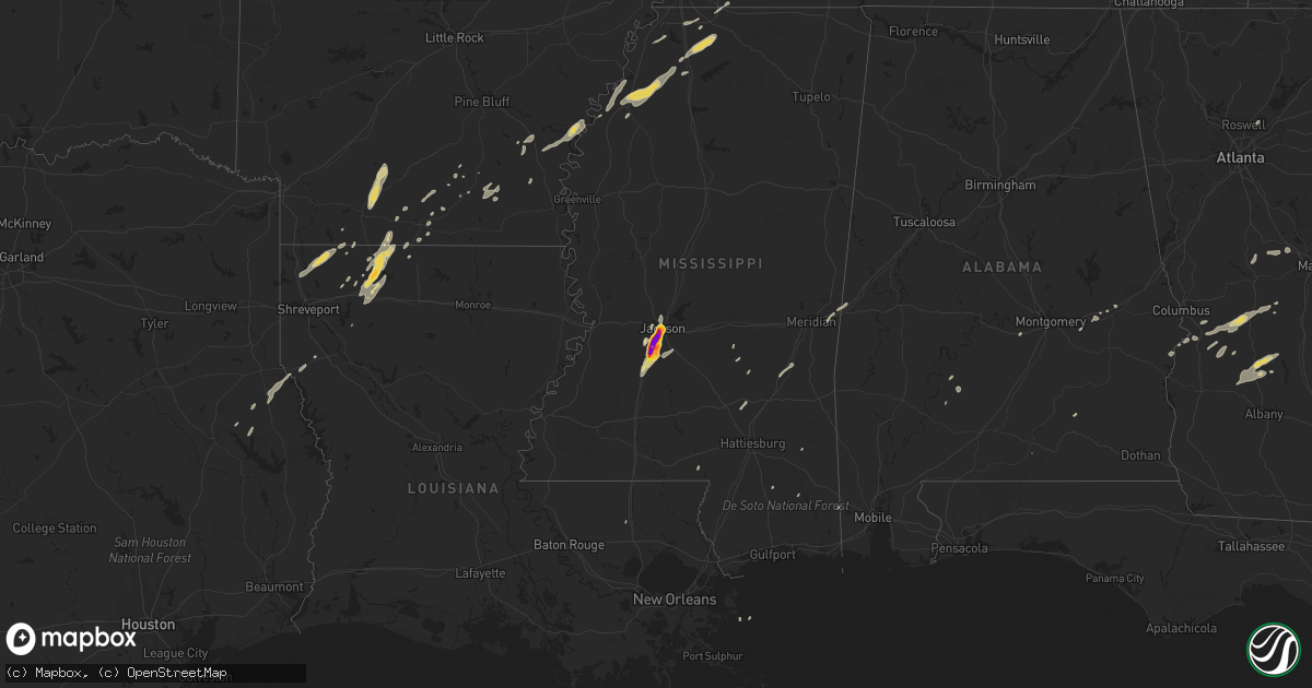
Hail Map on December 24, 2015
Get this storm
December 24 map
$229
one time, instant access
Download today. No call, no setup
Keep the $229
Bought the map and want the full workflow? Apply the entire $229 to a subscription within 7 days. None of it is wasted.
Every map, not just this one
This buys you this map. Subscription and you get every map we run, in the markets you choose from a few cities to whole states to nationwide. Plus real-time alerts the moment a storm fires.
Contact data
Name, contact info, occupancy, even credit band for addresses in the footprint. You go from where it hit to who to call.
Become the source they trust
Unlimited branding weather history reports on demand. You already have the documented answer ready for the property owner, and you are the one who showed up with it.
Property data and RoofTrace estimates
Pull up any address you have got, its value and the exact code rules for that jurisdiction, straight from One Click Code. Then RoofTrace estimates the squares, pitch, and roof value, priced the way you price.
States Impacted by Hail Map on December 24, 2015
Storm reports
Mississippi
| Date | Description |
|---|---|
| 12/24/20154:36 PM CST | Reported near downtown jackson |
| 12/24/20154:35 PM CST | Utility lines downed at martin luther king jr dr and carver st in jackson |
| 12/24/20154:33 PM CST | Quarter sized hail reported in terry. |
| 12/24/20154:30 PM CST | At least 2 inch sized hail reported in byram. Relayed via social media. |
| 12/24/20154:15 PM CST | Report with pictures relayed through social media of vehicle with cracked windshield after encountering hail up to the size of baseballs while driving south on intersta |
| 12/24/20154:10 PM CST | Public report from gas station of hailstones up to the size of baseballs falling along green gable road. |
| 12/23/20156:10 PM CST | A tree was down on highway 15. |
Georgia
| Date | Description |
|---|---|
| 12/24/20153:16 PM CST | Tree across roadway on ray owens road at eubank drive |
| 12/24/201512:29 PM CST | Several trees snapped or uprooted along mount carmel road in upson county. Ef-0 tornado confirmed from nws survey and archived radar data. Additional details in public |
| 12/24/201512:26 PM CST | Emergency manager reporting trees down in the culloden community. Possible tornado |
| 12/23/20158:50 PM CST | Public reported quarter inch hail in extreme northern schley county. |
Louisiana
| Date | Description |
|---|---|
| 12/23/201511:20 PM CST | Tree down on west 3rd street in homer |
Alabama
| Date | Description |
|---|---|
| 12/24/201510:27 AM CST | Strong wind gusts were reported to cause broken windows and downing of trees |
South Carolina
| Date | Description |
|---|---|
| 12/24/20154:25 PM CST | Trees in roadway fairview road and truex road |
| 12/24/20153:45 PM CST | Trees down on sweetwater road |
| 12/24/20153:31 PM CST | Trees down on garrett road in edgefield county. |
California
| Date | Description |
|---|---|
| 12/24/20155:15 PM CST | Ef0 damage has been confirmed in ceres from davis rd to vinewood dr. A carport collapsed causing damage to a house. Several fences were damaged and several trees were d |
| 12/24/20155:10 PM CST | Tornado 4 miles east of briggs ranch drive in folsom. Damage and intensity unknown at this time... Will follow up with another local storm report. |
| 12/24/20155:10 PM CST | Ef1 damage has been confirmed in el dorado hills and cameron park. Several residences were affected... With roofs damaged... Fences blown over... And large trees uprooted. On |
| 12/24/20155:00 PM CST | Update to previous lsr: ef0 tornado in ceres estimated on the ground around 3:00-3:05 pm pst. Damage between davis way and north central ave. To park e drive... And vinew (st |
| 12/24/20154:50 PM CST | Straight line winds. Tree down at coffee and athens road. Tree brought down 12 power poles. Shallow roots on tree. |
| 12/24/20154:24 PM CST | Investigating possible tornado in modesto/ceres will issue local storm report update soon as possible. |
Cities Impacted by Hail Map on December 24, 2015
- Appling, GA
- Homer, LA
- Athens, LA
- Jackson, MS
- Terry, MS
- Florence, MS
- Byram, MS
- Center, TX
- Joaquin, TX
- Holly Springs, MS
- Byhalia, MS
- Coldwater, MS
- Senatobia, MS
- Hornsby, TN
- Lucedale, MS
- Troy, AL
- Smackover, AR
- El Dorado, AR
- Benton, LA
- Springhill, LA
- Plain Dealing, LA
- Belcher, LA
- Sarepta, LA
- Sparta, GA
- Hernando, MS
- Olive Branch, MS
- Nesbit, MS
- Notasulga, AL
- Tuskegee, AL
- Americus, GA
- Bronwood, GA
- Plains, GA
- Dawson, GA
- Leslie, GA
- Smithville, GA
- Clarksdale, MS
- Hermitage, AR
- Preston, GA
- Richland, GA
- Hampton, AR
- Sledge, MS
- Marks, MS
- Lyon, MS
- Crystal Springs, MS
- McNeil, AR
- Chidester, AR
- Camden, AR
- Magnolia, AR
- Stephens, AR
- Edgefield, SC
- Haynesville, LA
- Meridian, MS
- Toomsuba, MS
- Rupert, GA
- Ellaville, GA
- Buena Vista, GA
- Mauk, GA
- Johnston, SC
- North Augusta, SC
- Ridge Spring, SC
- Thomson, GA
- Monetta, SC
- Trenton, SC
- Clarks Hill, SC
- Minden, LA
- Wiggins, MS
- Watson, AR
- Snow Lake, AR
- Richland, MS
- Flowood, MS
- Forest, MS
- Bay Springs, MS
- Shongaloo, LA
- Buchanan, TN
- Murray, KY
- Puryear, TN
- Hazel, KY
- Tunica, MS
- Dubberly, LA
- Gibsland, LA
- Junction City, AR
- Fountain Hill, AR
- Dumas, AR
- Raymond, MS
- Mansfield, LA
- Soso, MS
- Collins, MS
- Ellisville, MS
- Seminary, MS
- Raleigh, MS
- Middleton, TN
- Omaha, GA
- Rossville, TN
- Warren, AR
- Coahoma, MS
- Alligator, MS
- Allensville, KY
- Guthrie, KY
- Cecil, AL
- Culloden, GA
- Forsyth, GA
- Barnesville, GA
- Milledgeville, GA
- Eatonton, GA
- Shorter, AL
- Vossburg, MS
- Heidelberg, MS
- Pachuta, MS
- Hazlehurst, MS
- Ridgeland, MS
- Eufaula, AL
- Ringgold, LA
- Chireno, TX
- San Augustine, TX
- Clinton, MS
- Independence, LA
- York, AL
- Cuba, AL
- Lauderdale, MS
- Crenshaw, MS
- Sardis, MS
- Como, MS
- Lambert, MS
- Pearl, MS
- Cusseta, GA
- Butler, GA
- Reynolds, GA
- De Soto, GA
- Tillar, AR
- Gunnison, MS
- Gordon, GA
- Thomaston, GA
- Lillie, LA
- Foxworth, MS
- Sandy Hook, MS
- Monticello, AR
- Wilmar, AR
- Banks, AR
- Alpharetta, GA
- Duluth, GA
- Beatrice, AL
- Dermott, AR
- Lowndesboro, AL
- Hayneville, AL