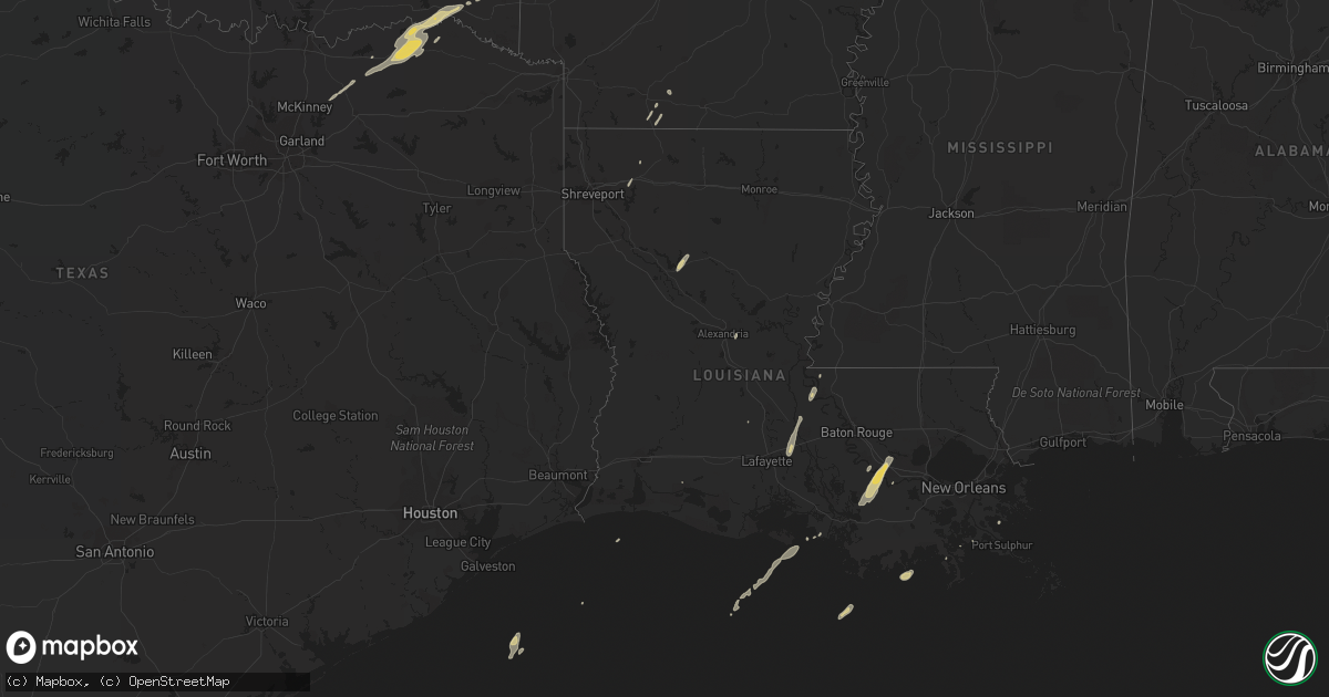
Hail Map on December 22, 2015
Get this storm
December 22 map
$229
one time, instant access
Download today. No call, no setup
Keep the $229
Bought the map and want the full workflow? Apply the entire $229 to a subscription within 7 days. None of it is wasted.
Every map, not just this one
This buys you this map. Subscription and you get every map we run, in the markets you choose from a few cities to whole states to nationwide. Plus real-time alerts the moment a storm fires.
Contact data
Name, contact info, occupancy, even credit band for addresses in the footprint. You go from where it hit to who to call.
Become the source they trust
Unlimited branding weather history reports on demand. You already have the documented answer ready for the property owner, and you are the one who showed up with it.
Property data and RoofTrace estimates
Pull up any address you have got, its value and the exact code rules for that jurisdiction, straight from One Click Code. Then RoofTrace estimates the squares, pitch, and roof value, priced the way you price.
Storm reports
Oklahoma
| Date | Description |
|---|---|
| 12/22/20155:30 AM CST | A local report indicates 1.00 inch wind near VALLIANT |
South Carolina
| Date | Description |
|---|---|
| 12/22/20152:47 AM CST | The national weather service in charleston sc examined photographs provided by berkeley county emergency management and areal drone footage provided by skyview aerial s |
| 12/22/20152:27 AM CST | The national weather service in charleston sc examined photographs provided by berkeley county emergency management and aerial drone footage provided by skyview aerial |
Louisiana
| Date | Description |
|---|---|
| 12/22/201512:30 AM CST | Nearly aa battery sized hail fell in sorrento. |
Cities Impacted by Hail Map on December 22, 2015
- Sorrento, LA
- Paulina, LA
- Saint James, LA
- Convent, LA
- Napoleonville, LA
- Belle Rose, LA
- Fort Towson, OK
- Hugo, OK
- Breaux Bridge, LA
- Darrow, LA
- Magnolia, AR
- Leonard, TX
- Celeste, TX
- Wolfe City, TX
- Honey Grove, TX
- Grant, OK
- Pineville, LA
- Deville, LA
- Brookston, TX
- Paris, TX
- Winnfield, LA
- Detroit, TX
- Powderly, TX
- Arthur City, TX
- Sumner, TX
- Roxton, TX
- Valliant, OK
- Donaldsonville, LA
- Geismar, LA
- Wright City, OK
- Danville, AR
- Dulac, LA
- Natchitoches, LA
- Farmersville, TX
- Blue Ridge, TX
- Saint Francisville, LA
- Vacherie, LA
- Smithville, OK
- Emerson, AR
- Franklin, LA
- Mount Holly, AR
- Stephens, AR
- Blossom, TX
- Petty, TX
- Sawyer, OK
- Ladonia, TX
- Saint Amant, LA
- Bethel, OK
- Broken Bow, OK
- Opelousas, LA
- Batchelor, LA
- Morganza, LA
- Pierre Part, LA
- Doyline, LA
- Minden, LA
- Krotz Springs, LA
- Saint Martinville, LA
- Port Barre, LA
- Lottie, LA
- Fordoche, LA