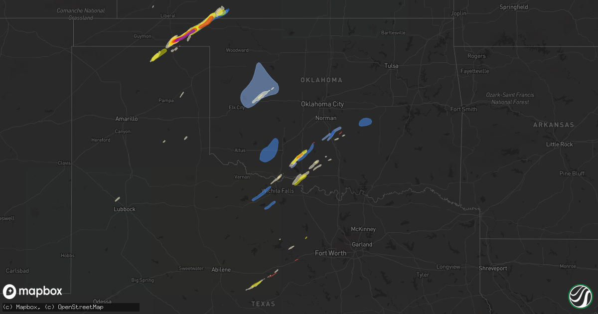
Hail Map on December 12, 2022
Get this storm
December 12 map
$229
one time, instant access
Download today. No call, no setup
Keep the $229
Bought the map and want the full workflow? Apply the entire $229 to a subscription within 7 days. None of it is wasted.
Every map, not just this one
This buys you this map. Subscription and you get every map we run, in the markets you choose from a few cities to whole states to nationwide. Plus real-time alerts the moment a storm fires.
Contact data
Name, contact info, occupancy, even credit band for addresses in the footprint. You go from where it hit to who to call.
Become the source they trust
Unlimited branding weather history reports on demand. You already have the documented answer ready for the property owner, and you are the one who showed up with it.
Property data and RoofTrace estimates
Pull up any address you have got, its value and the exact code rules for that jurisdiction, straight from One Click Code. Then RoofTrace estimates the squares, pitch, and roof value, priced the way you price.
States Impacted by Hail Map on December 12, 2022
Storm reports
Oklahoma
| Date | Description |
|---|---|
| 12/12/20224:41 AM CST | At 1041 PM CST, a severe thunderstorm was located over Lelia Lake, or 6 miles east of Clarendon, moving east at 50 mph. HAZARD...Quarter size hail. SOURCE...Radar indicated. IMPACT...Damage to vehicles is expected. Locations impacted include... Wellington, Clarendon, Shamrock, Mclean, Hedley, Dodson, Lutie, Lelia Lake, Twitty, Lela, Quail, Samnorwood, Dozier and Alanreed. |
| 12/12/20224:20 AM CST | At 1020 PM CST, severe thunderstorms were located along a line extending from 3 miles northeast of Lake Marvin to 4 miles east of Lefors, moving northeast at 45 mph. HAZARD...60 mph wind gusts and quarter size hail. SOURCE...Radar indicated. IMPACT...Minor damage to roofs, siding, and trees is possible. Hail damage to vehicles is expected. Locations impacted include... Canadian, Miami, Briscoe, Wheeler, Lefors, Higgins, New Mobeetie, Allison, Glazier, Lake Marvin, Kellerville, Lora and Mobeetie. |
| 12/12/20224:10 AM CST | Social media report. |
| 12/12/20224:06 AM CST | At 1005 PM CST, a severe thunderstorm was located 11 miles north of Knowles, or 12 miles west of Englewood, moving northeast at 35 mph. HAZARD...60 mph wind gusts and quarter size hail. SOURCE...Radar indicated. IMPACT...Hail damage to vehicles is expected. Expect wind damage to roofs, siding, and trees. This severe thunderstorm will remain over mainly rural areas of southeastern Meade and southwestern Clark Counties. |
| 12/12/20223:42 AM CST | At 941 PM CST, a severe thunderstorm was located near Acres, moving northeast at 40 mph. HAZARD...Ping pong ball size hail and 60 mph wind gusts. SOURCE...Radar indicated. IMPACT...People and animals outdoors will be injured. Expect hail damage to roofs, siding, windows, and vehicles. Expect wind damage to roofs, siding, and trees. This severe thunderstorm will be near... Acres around 945 PM CST. Ashland around 1000 PM CST.Other locations in the path of this severe thunderstorm includeSitka. |
| 12/12/20223:07 AM CST | At 907 PM CST, a severe thunderstorm was located near Knowles, or 11 miles southwest of Englewood, moving northeast at 40 mph. HAZARD...60 mph wind gusts and quarter size hail. SOURCE...Radar indicated. IMPACT...Hail damage to vehicles is expected. Expect wind damage to roofs, siding, and trees. This severe thunderstorm will be near... Englewood around 925 PM CST.Other locations in the path of this severe thunderstorm include Acresand Ashland. |
| 12/12/20222:18 AM CST | At 817 PM CST, a severe thunderstorm was located 7 miles northwest of Waka, or 9 miles north of Spearman, moving northeast at 45 mph. HAZARD...60 mph wind gusts and quarter size hail. SOURCE...Radar indicated. IMPACT...Minor damage to roofs, siding, and trees is possible. Hail damage to vehicles is expected. Locations impacted include... Perryton, Spearman, Bryans Corner, Farnsworth, Boyd, Waka and Balko. |
| 12/12/20221:52 AM CST | At 751 PM CST, a severe thunderstorm was located over Perryton, moving northeast at 60 mph. HAZARD...60 mph wind gusts and quarter size hail. SOURCE...Radar indicated. IMPACT...Minor damage to roofs, siding, and trees is possible. Hail damage to vehicles is expected. Locations impacted include... Perryton, Booker, Elmwood, Slapout and Balko. |
| 12/12/20221:10 AM CST | Measured at butler mesonet site. |
| 12/11/20229:16 PM CST | Estimated ping pong ball to tennis ball size hail while viewing through a window while sheltered in place. |
Texas
| Date | Description |
|---|---|
| 12/12/20225:42 AM CST | Reports of barns damaged along hwy 281 se of jacksboro. |
| 12/12/20223:50 AM CST | At 949 PM CST, a severe thunderstorm was located 6 miles west of Groom, or 9 miles northeast of Claude, moving northeast at 55 mph. HAZARD...60 mph wind gusts and quarter size hail. SOURCE...Radar indicated. IMPACT...Minor damage to roofs, siding, and trees is possible. Hail damage to vehicles is expected. Locations impacted include... Pampa, Claude, White Deer, Mclean, Groom, Lefors, Howardwick, Lake Mcclellan, Kingsmill, Alanreed, Greenbelt Lake and Goodnight. |
Cities Impacted by Hail Map on December 12, 2022
- Elmore City, OK
- Hedley, TX
- Waurika, OK
- Carbon, TX
- Byars, OK
- Beaver, OK
- Laverne, OK
- Perryton, TX
- Balko, OK
- Rosston, OK
- Ashland, KS
- Englewood, KS
- Gate, OK
- Forgan, OK
- Inyokern, CA
- Ridgecrest, CA
- Duncan, OK
- Graham, OK
- Healdton, OK
- Loco, OK
- Wichita Falls, TX
- Randlett, OK
- Burkburnett, TX
- Devol, OK
- Iowa Park, TX
- Watonga, OK
- Geary, OK
- Lone Pine, CA
- Miami, TX
- Comanche, OK
- Marlow, OK
- Walters, OK
- Spearman, TX
- Gruver, TX
- Hennepin, OK
- Weatherford, OK
- Arapaho, OK
- Springville, CA
- Shallowater, TX
- Tribune, KS
- Pauls Valley, OK
- Paoli, OK
- Graham, TX
- Rising Star, TX
- Graford, TX
- Mineral Wells, TX
- Abernathy, TX
- Cross Plains, TX
- Ranger, TX
- Gorman, TX
- Clinton, OK
- Thomas, OK
- Custer City, OK
- Ryan, OK
- Petrolia, TX
- Byers, TX
- Poolville, TX
- Henrietta, TX
- Holliday, TX
- Seymour, TX
- Electra, TX
- Rush Springs, OK
- Wayne, OK
- Lexington, OK
- Wanette, OK
- Santo, TX
- Chester, OK
- Canute, OK
- Butler, OK
- Seiling, OK
- Taloga, OK
- Canton, OK
- Fay, OK
- Foss, OK
- Oakwood, OK
- Putnam, OK
- Leedey, OK
- Medicine Park, OK
- Snyder, OK
- Frederick, OK
- Cache, OK
- Chattanooga, OK
- Indiahoma, OK
- Lawton, OK
- Loveland, OK
- Elgin, OK
- Faxon, OK
- Temple, OK
- Lindsay, OK
- Maysville, OK
- Holdenville, OK
- Seminole, OK
- Maud, OK
- Wewoka, OK
- Bowlegs, OK