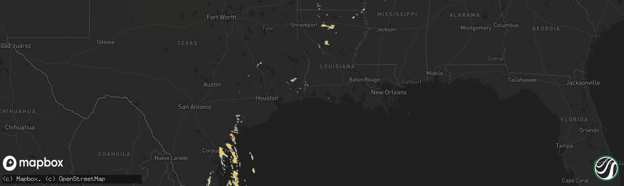
Hail Map on December 4, 2012
The weather event on December 4, 2012 includes Hail map. 4 states and 88 cities were impacted and suffered possible damage. The total estimated number of properties impacted is 0.
Want more than just the map?
Turn this storm into a full workflow.
- Owner + property data so you know who to knock
- OnDemand branded weather history reports to win the "did we even have hail?" argument
- RoofTrace estimate so reps stop guessing numbers at the door
Bought this map? Upgrade within 7 days and we'll credit the $230. (10-15 min setup call)
Hail
0
Estimated number of impacted properties by a 1.00" hail or larger253
Estimated number of impacted properties by a 1.75" hail or larger0
Estimated number of impacted properties by a 2.50" hail or largerStates Impacted by Hail Map on December 4, 2012
Storm reports
Texas
| Date | Description |
|---|---|
| 12/04/201212:05 AM CST | The precinct 1 garage west of raymondville on highway 186 sustained heavy damage from straight line thunderstorm winds. The garage doors were blown down and a section o |
| 12/03/201211:48 PM CST | Barn destroyed a few miles west of raymondville crushing a car. Winds estimated at 70 to 80 mph. Hail was heard but size unknown. |
| 12/03/201211:45 PM CST | Raymondville pd estimates 60mph wind when storm came through. |
| 12/03/20126:01 PM CST | Raws site mirt2 on matagorda island recorded 61 mph wind gust. Time is approx from radar. |
Louisiana
| Date | Description |
|---|---|
| 12/04/20122:20 PM CST | Tree down on mt zion road near mt zion church |
Mississippi
| Date | Description |
|---|---|
| 12/04/20123:30 PM CST | Two trees down in grenada. |
Cities Impacted by Hail Map on December 4, 2012
- Greenwood, MS
- Brownsville, TX
- Bernice, LA
- Homer, LA
- San Benito, TX
- Vilonia, AR
- Greenbrier, AR
- Conway, AR
- Gore Springs, MS
- Port O'Connor, TX
- Tivoli, TX
- Rockport, TX
- Pine Bluff, AR
- Carrollton, MS
- Moorhead, MS
- Itta Bena, MS
- Grenada, MS
- Vinton, LA
- Raymondville, TX
- Pontotoc, MS
- Silsbee, TX
- Kountze, TX
- Simsboro, LA
- Choudrant, LA
- Ruston, LA
- Chatham, LA
- Eros, LA
- Quitman, LA
- Edcouch, TX
- Atlanta, LA
- Coffeeville, MS
- Corpus Christi, TX
- Holcomb, MS
- Pioneer, LA
- Oak Grove, LA
- Pittsboro, MS
- Big Creek, MS
- Armstrong, TX
- Lyford, TX
- Belden, MS
- Tupelo, MS
- Starks, LA
- Bienville, LA
- Ganado, TX
- Edna, TX
- Natchez, LA
- Robeline, LA
- Natchitoches, LA
- Seadrift, TX
- Port Lavaca, TX
- Midway, TX
- Bruce, MS
- Weslaco, TX
- Mercedes, TX
- Winnfield, LA
- Emerson, AR
- Sidon, MS
- Madisonville, TX
- Portland, TX
- Water Valley, MS
- Sherrill, AR
- Nederland, TX
- Oxford, MS
- Sheridan, AR
- Anderson, TX
- Harlingen, TX
- Combes, TX
- Arcadia, LA
- Houlka, MS
- Okolona, MS
- Beaumont, TX
- La Feria, TX
- Mayersville, MS
- Banner, MS
- Vanderbilt, TX
- New Ulm, TX
- Orange, TX
- Lolita, TX
- Calhoun City, MS
- Aransas Pass, TX
- Scobey, MS
- Cascilla, MS
- Buna, TX
- Houston, MS
- Magnolia, AR
- Lovelady, TX
- Hector, AR
- Austwell, TX