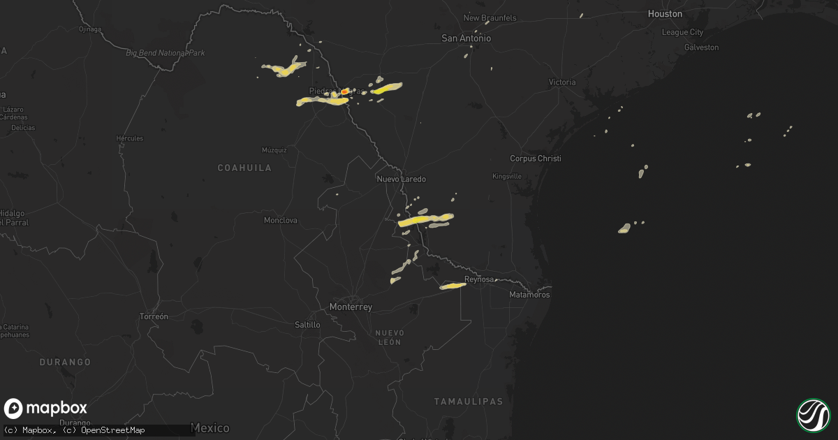
Hail Map on November 22, 2014
Get this storm
November 22 map
$229
one time, instant access
Download today. No call, no setup
Keep the $229
Bought the map and want the full workflow? Apply the entire $229 to a subscription within 7 days. None of it is wasted.
Every map, not just this one
This buys you this map. Subscription and you get every map we run, in the markets you choose from a few cities to whole states to nationwide. Plus real-time alerts the moment a storm fires.
Contact data
Name, contact info, occupancy, even credit band for addresses in the footprint. You go from where it hit to who to call.
Become the source they trust
Unlimited branding weather history reports on demand. You already have the documented answer ready for the property owner, and you are the one who showed up with it.
Property data and RoofTrace estimates
Pull up any address you have got, its value and the exact code rules for that jurisdiction, straight from One Click Code. Then RoofTrace estimates the squares, pitch, and roof value, priced the way you price.
States Impacted by Hail Map on November 22, 2014
Storm reports
Oregon
| Date | Description |
|---|---|
| 11/22/20143:20 PM CST | Approximately 50 douglas fir trees uprooted. Tree average diameter 10 to 14 inches. |
Texas
| Date | Description |
|---|---|
| 11/22/20145:55 PM CST | Half dollar size hail reported on fm 1021 se of eagle pass. |
| 11/22/20145:22 PM CST | A local report indicates 60 MPH wind near ZAPATA |
| 11/22/20145:22 PM CST | A local report indicates 1.00 inch wind near ZAPATA |
| 11/22/20145:20 PM CST | Emergency manager reports a few older houses had roofs partially removed several metal buildings trailers had roofs totally removed...a chain link fence was blown down. |
| 11/21/20149:31 PM CST | Large tree limbs broken |
| 11/21/20149:18 PM CST | Trees blown down in cuero due to thunderstorm outflow winds. Time estimated from radar. |
| 11/21/20149:00 PM CST | Tree uprooted near prairie lea. Time estimated from radar. |
| 11/21/20148:52 PM CST | Several 2 inch diameter tree limbs blown down |
| 11/21/20148:26 PM CST | 3 to 4 inch diameter tree limb broken by thunderstorm winds |
| 11/21/20148:12 PM CST | Several tree limbs of 2 to 3 inch diameter broken by thunderstorm winds |
| 11/21/20148:01 PM CST | A local report indicates 60 MPH wind near 5 N LEMING |
| 11/21/20147:58 PM CST | A local report indicates 63 MPH wind near SAN ANTONIO |
| 11/21/20147:46 PM CST | Tree down on a car near the kings inn. |
| 11/21/20147:16 PM CST | Kingsville police reported a couple trees down in the city. |
| 11/21/20146:45 PM CST | Hail size went from quarter to half dollar size then down to pea size |
| 11/21/20146:45 PM CST | A local report indicates 68 MPH wind near CRYSTAL CITY |
| 11/21/20146:30 PM CST | Hen egg size hail estimated at a residence. Corrected date in lsr. |
| 11/21/20146:01 PM CST | Thunderstorm wind gusts blew out some power transformers between knippa and uvalde |
Cities Impacted by Hail Map on November 22, 2014
- Eagle Pass, TX
- Lamesa, TX
- Schertz, TX
- Austin, TX
- Manchaca, TX
- Bulverde, TX
- Zapata, TX
- Crystal City, TX
- Midland, TX
- Hebbronville, TX
- Guerra, TX
- Encinal, TX
- Carrizo Springs, TX
- Dryden, TX
- Big Lake, TX
- Big Spring, TX
- Winters, TX
- Talpa, TX
- Paducah, TX
- Converse, TX
- San Antonio, TX
- Batesville, TX
- Stanton, TX
- Ballinger, TX
- Weimar, TX
- Columbus, TX
- Carlsbad, TX
- Ira, TX
- La Pryor, TX
- Marion, TX
- New Braunfels, TX
- San Ygnacio, TX
- Blackwell, TX
- Laughlin Afb, TX
- Del Rio, TX