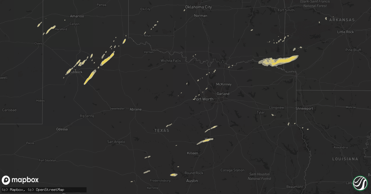
Hail Map on November 21, 2011
Get this storm
November 21 map
$229
one time, instant access
Download today. No call, no setup
Keep the $229
Bought the map and want the full workflow? Apply the entire $229 to a subscription within 7 days. None of it is wasted.
Every map, not just this one
This buys you this map. Subscription and you get every map we run, in the markets you choose from a few cities to whole states to nationwide. Plus real-time alerts the moment a storm fires.
Contact data
Name, contact info, occupancy, even credit band for addresses in the footprint. You go from where it hit to who to call.
Become the source they trust
Unlimited branding weather history reports on demand. You already have the documented answer ready for the property owner, and you are the one who showed up with it.
Property data and RoofTrace estimates
Pull up any address you have got, its value and the exact code rules for that jurisdiction, straight from One Click Code. Then RoofTrace estimates the squares, pitch, and roof value, priced the way you price.
States Impacted by Hail Map on November 21, 2011
Storm reports
Oklahoma
| Date | Description |
|---|---|
| 11/20/20118:42 PM CST | Trained spotter estimated winds at 70 mph. Hail was also occurring with heavy rainfall. Size undetermined at this time. |
Arkansas
| Date | Description |
|---|---|
| 11/20/20119:22 PM CST | Asos pk wnd 09050/0322 on top of a reflectivity comma head |
| 11/20/20119:20 PM CST | Tree down on hwy 41 between winthrop and horatio. |
New Mexico
| Date | Description |
|---|---|
| 11/21/20114:10 PM CST | Law enforcement reports wind gusts near 60 mph and near zero visibility due to blowing dust in carlsbad. |
| 11/21/20113:56 PM CST | 62 mph wind gust reported by the carlsbad asos. |
Texas
| Date | Description |
|---|---|
| 11/21/201110:46 AM CST | Pea to quarter size hail covering the ground. |
| 11/21/20119:43 AM CST | A local report indicates 1.00 inch wind near 4 NE ABERNATHY |
| 11/21/20118:58 AM CST | A local report indicates 1.00 inch wind near SMYER |
| 11/21/20112:00 AM CST | Tree reported down off of fm 2198. |
| 11/20/201111:17 PM CST | Public report of penny to quarter sized hail at the walmart in hewitt. |
| 11/20/20116:45 PM CST | Several power lines and trees blown down in bells. |
Cities Impacted by Hail Map on November 21, 2011
- Mcadoo, TX
- Roaring Springs, TX
- Matador, TX
- Lubbock, TX
- Ropesville, TX
- Shallowater, TX
- Levelland, TX
- Johnson City, TX
- Round Mountain, TX
- Brady, TX
- Lorenzo, TX
- Post, TX
- Crosbyton, TX
- Tahoka, TX
- Ralls, TX
- Hereford, TX
- Friona, TX
- Foreman, AR
- Horatio, AR
- Winthrop, AR
- Lockesburg, AR
- Eagletown, OK
- De Queen, AR
- Clarksville, TX
- Dierks, AR
- Garvin, OK
- Bagwell, TX
- Haworth, OK
- Idabel, OK
- Woodway, TX
- Waco, TX
- Childress, TX
- Smithville, OK
- Hatfield, AR
- Haslet, TX
- Bridgeport, TX
- Floydada, TX
- Petersburg, TX
- Abernathy, TX
- Idalou, TX
- Comanche, TX
- Horseshoe Bay, TX
- Marble Falls, TX
- Blair, OK
- Minco, OK
- Union City, OK
- Penelope, TX
- Ringling, OK
- Ola, AR
- McGregor, TX
- Carthage, TX
- Hillsboro, TX
- West, TX
- Abbott, TX
- Malone, TX
- Burnet, TX
- Dardanelle, AR
- Morrilton, AR
- Casa, AR
- Broadview, NM
- San Jon, NM
- Paducah, TX
- Lorena, TX
- Hewitt, TX
- Weatherford, TX
- Overton, TX
- Hartshorne, OK
- Valley View, TX
- Era, TX
- Detroit, TX
- Valliant, OK
- Nashville, AR
- Memphis, TX
- Fort Worth, TX
- Azle, TX
- Aquilla, TX
- Decatur, TX
- Ryan, OK
- Altus, OK
- Olustee, OK
- Oglesby, TX
- Crawford, TX
- Collinsville, TX
- Gainesville, TX
- Mena, AR
- Dublin, TX
- Argyle, TX
- Roanoke, TX
- Whitesboro, TX
- Hobart, OK
- Hendrix, OK
- Ravenna, TX
- Denison, TX
- Mason, TX
- Watson, OK
- Gary, TX
- Broken Bow, OK
- Arthur City, TX
- Paris, TX
- Converse, LA
- Umpire, AR