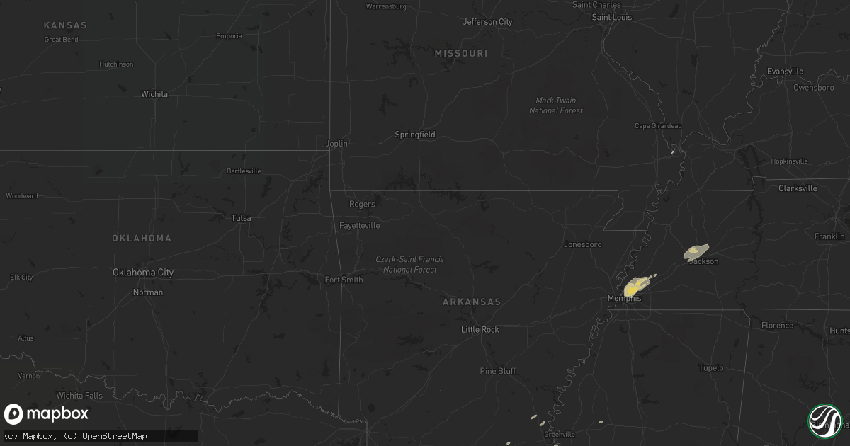
Hail Map on November 18, 2016
Get this storm
November 18 map
$229
one time, instant access
Download today. No call, no setup
Keep the $229
Bought the map and want the full workflow? Apply the entire $229 to a subscription within 7 days. None of it is wasted.
Every map, not just this one
This buys you this map. Subscription and you get every map we run, in the markets you choose from a few cities to whole states to nationwide. Plus real-time alerts the moment a storm fires.
Contact data
Name, contact info, occupancy, even credit band for addresses in the footprint. You go from where it hit to who to call.
Become the source they trust
Unlimited branding weather history reports on demand. You already have the documented answer ready for the property owner, and you are the one who showed up with it.
Property data and RoofTrace estimates
Pull up any address you have got, its value and the exact code rules for that jurisdiction, straight from One Click Code. Then RoofTrace estimates the squares, pitch, and roof value, priced the way you price.
States Impacted by Hail Map on November 18, 2016
Storm reports
Michigan
| Date | Description |
|---|---|
| 11/18/20165:55 PM CST | Well built barn demolished... Trees down... Large wooden swing set blown away. Time estimated by radar. . |
| 11/17/20167:55 PM CST | A local report indicates 59 MPH wind near BAD AXE |
| 11/17/20167:10 PM CST | Numerous reports of trees and power lines throughout the county |
| 11/17/20167:00 PM CST | Report via twitter |
| 11/17/20166:42 PM CST | Numerous reports of trees down along the i-96 corridor between brighton and howell |
| 11/17/20166:30 PM CST | Widespread reports of tree damage across washtenaw county |
| 11/17/20166:11 PM CST | Asos station jackson county-reynolds field airport /jxn/. |
Indiana
| Date | Description |
|---|---|
| 11/18/20165:59 PM CST | Power lines and tree down. |
| 11/18/20165:56 PM CST | . |
| 11/18/20165:55 PM CST | Wind measured by handheld anemometer. |
| 11/18/20165:37 PM CST | 4 to 5 inch in diameter trees down. |
| 11/18/20165:35 PM CST | Power lines down on car with people inside. |
| 11/18/20165:32 PM CST | Approximately 100 foot tall pine tree snapped off 4 feet above the roots. . |
| 11/18/20165:10 PM CST | Power lines down on car. . |
| 11/18/20165:10 PM CST | . |
| 11/18/20165:08 PM CST | Large tree limbs down. |
| 11/18/20165:02 PM CST | Time approximate |
| 11/18/20165:02 PM CST | Large tree limbs down. Time approximated. |
| 11/18/20164:50 PM CST | Power out with torrential rain. |
| 11/18/20164:49 PM CST | Large spruce tree uprooted. Time estimated by radar. |
| 11/18/20164:47 PM CST | Tore the metal roof off a building and blew up a transformer. Lots of debris. |
| 11/18/20164:45 PM CST | A few trees came down near beaver dam lake. |
| 11/18/20164:43 PM CST | Measured by asos at airport. |
| 11/18/20164:37 PM CST | *** 1 inj *** report of tree down on vehicle with one person injured. |
| 11/18/20164:33 PM CST | Power outages. Trees knocked down. |
| 11/18/20164:30 PM CST | A tree is blocking over a lane in the 6300 block of logansport road. |
| 11/18/20164:22 PM CST | Via kggp asos station. |
| 11/18/20164:15 PM CST | Several trees down on the north side of greencastle |
| 11/18/20164:10 PM CST | Part of a center pivot irrigation system was rolled over. Reported at 5500 e 75 n winamac... In. |
| 11/18/20164:10 PM CST | Car blown off road on u.s. 231. Time approximate. |
| 11/18/20164:05 PM CST | 7 inch diameter 30 foot tall healthy tree snapped in half. . |
| 11/18/20164:00 PM CST | Tree and large limbs downed. |
| 11/18/20163:30 PM CST | Power poles downed at 1484 south stringtown rd. |
Tennessee
| Date | Description |
|---|---|
| 11/18/20165:52 PM CST | Multiple large trees down across hwy 70 in stanton and hwy 76 in koko. |
| 11/17/20166:30 PM CST | Highway 138 in madison county trees fell on houses. |
| 11/17/20166:25 PM CST | Fallen limbs and trees dropped power lines around russell and forest avenues in jackson. |
Illinois
| Date | Description |
|---|---|
| 11/18/20163:35 PM CST | A local report indicates 59 MPH wind near ROBINSON |
| 11/18/20163:15 PM CST | Powerlines down in the city of danville. |
| 11/18/20163:03 PM CST | Powerlines down in catlin |
Cities Impacted by Hail Map on November 18, 2016
- Starks, LA
- Chatfield, MN
- East Troy, WI
- Eagle, WI
- Merryville, LA
- Singer, LA
- Sinton, TX
- Beeville, TX
- Sandia, TX
- Robstown, TX
- Charleston, MO
- Hamburg, AR
- Agua Dulce, TX
- Alice, TX
- Warren, TX
- Arlington, TN
- Bells, TN
- Humboldt, TN
- Gadsden, TN
- Woodruff, WI
- Mukwonago, WI
- Armstrong, TX
- Oakfield, TN
- Medina, TN
- Denmark, TN
- Jackson, TN
- Milan, TN
- Memphis, TN
- Schlater, MS
- Moscow, TX
- Millington, TN
- Bon Wier, TX
- McGehee, AR
- Provencal, LA
- Alvin, TX
- Manvel, TX
- Rosharon, TX
- Brighton, TN
- Atoka, TN
- Skidmore, TX
- Waukesha, WI
- Hazelhurst, WI
- Mason, TN
- Drummonds, TN
- Eudora, AR
- Kountze, TX
- Cuero, TX
- Ganado, TX
- Byhalia, MS
- Damon, TX
- Needville, TX
- North Prairie, WI
- Goliad, TX
- Lake Village, AR
- Dermott, AR
- Florien, LA
- Apple Springs, TX
- Leesville, LA
- Mora, LA
- Bossier City, LA
- Mathis, TX
- Taft, TX
- Livingston, TX
- Harlingen, TX