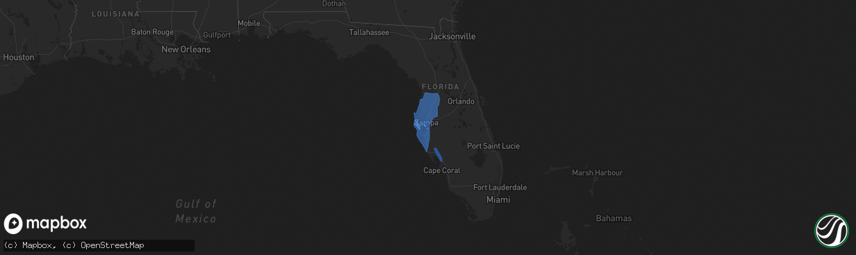
Hail Map on November 11, 2020
The weather event on November 11, 2020 includes Wind map. 1 state and 63 cities were impacted and suffered possible damage. The total estimated number of properties impacted is 0.
Want more than just the map?
Turn this storm into a full workflow.
- Owner + property data so you know who to knock
- OnDemand branded weather history reports to win the "did we even have hail?" argument
- RoofTrace estimate so reps stop guessing numbers at the door
Bought this map? Upgrade within 7 days and we'll credit the $230. (10-15 min setup call)
Wind
0
Estimated number of impacted properties by a 1.00" hail or larger0
Estimated number of impacted properties by a 1.75" hail or larger0
Estimated number of impacted properties by a 2.50" hail or largerStates Impacted by Hail Map on November 11, 2020
Storm reports
North Carolina
| Date | Description |
|---|---|
| 11/10/20209:00 PM CST | Wind damage to 6-8 camper vehicles was reported at laurel lakes campground near salemburg. |
| 11/10/20208:50 PM CST | At beech mountain ski resort... Numerous 50 to 70 foot spruce pines were blown over or snapped. The windows in one of the ski lift shacks were blown out. Relayed by noa |
Florida
| Date | Description |
|---|---|
| 11/10/202011:25 PM CST | At 524 PM EST, severe thunderstorms were located along a line extending from 8 miles northeast of Shark Valley Obs Tower to near Homestead General Airport to 7 miles southwest of Royal Palm Ranger, moving north at 45 mph. HAZARD...60 mph wind gusts. SOURCE...Radar indicated. IMPACT...Expect damage to roofs, siding, and trees. Locations impacted include... Homestead, Homestead Miami Speedway, Homestead General Airport, The Redland and Kendall. |
| 11/10/202010:54 PM CST | At 454 PM EST, severe thunderstorms were located along a line extending from 7 miles west of Shark Valley Obs Tower to 9 miles southeast of Mahogany Hammock, moving northeast at 30 mph. HAZARD...60 mph wind gusts. SOURCE...Radar indicated. IMPACT...Expect damage to roofs, siding, and trees. Locations impacted include... Homestead General Airport, The Redland, Loop Road Ee Center, Everglades National Park and Flamingo. |
| 11/10/20208:55 PM CST | At 254 PM EST, severe thunderstorms were located along a line extending from 6 miles east of Wilderness Waterway to near Northwest Cape Sable, moving north at 45 mph. HAZARD...60 mph wind gusts. SOURCE...Radar indicated. IMPACT...Expect damage to roofs, siding, and trees. Locations impacted include... Northwest Cape Sable, Wilderness Waterway, Loop Road Ee Center, Dade-Collier Training Airport and Fortymile Bend. |
| 11/10/20208:13 PM CST | At 213 PM EST, severe thunderstorms were located along a line extending from Big Cypress National Preserve to near Loop Road Ee Center to 6 miles northwest of Northwest Cape Sable, moving northeast at 40 mph. HAZARD...60 mph wind gusts. SOURCE...Radar indicated. IMPACT...Expect damage to roofs, siding, and trees. Locations impacted include... Northwest Cape Sable, Wilderness Waterway, Hendry Correctional, Loop Road Ee Center and Big Cypress Seminole Reservation. |
| 11/10/20207:53 PM CST | At 152 PM EST, a severe thunderstorm was located near Wilderness Waterway, or 21 miles southeast of Chokoloskee, moving north at 35 mph. HAZARD...60 mph wind gusts. SOURCE...Radar indicated. IMPACT...Expect damage to roofs, siding, and trees. Locations impacted include... Wilderness Waterway, Loop Road Ee Center, Big Cypress National Preserve and Dade-Collier Training Airport. |
Georgia
| Date | Description |
|---|---|
| 11/11/20209:00 AM CST | Trees down near hamilton mill area near i-85. |
| 11/11/20201:22 AM CST | 2 large tree limbs down on russell parkway eastbound... Just west of ga highway 247. |
| 11/10/20209:36 PM CST | Trees/power lines down |
| 11/10/20209:36 PM CST | Trees/power lines down |
| 11/10/20209:36 PM CST | Trees/power lines down |
Virginia
| Date | Description |
|---|---|
| 11/11/202012:57 AM CST | At 656 PM EST, a severe thunderstorm was located over Radford, moving northeast at 40 mph. HAZARD...60 mph wind gusts. SOURCE...Radar indicated. IMPACT...Expect damage to roofs, siding, and trees. Locations impacted include... Blacksburg... Christiansburg... Radford... Dublin... Newport... Pilot... and Shawsville.This includes the following location: Virginia Tech. |
Cities Impacted by Hail Map on November 11, 2020
- Arcadia, FL
- Port Charlotte, FL
- Punta Gorda, FL
- North Port, FL
- Pinellas Park, FL
- Seminole, FL
- Largo, FL
- Belleair Beach, FL
- Saint Petersburg, FL
- Indian Rocks Beach, FL
- Clearwater Beach, FL
- Clearwater, FL
- Apollo Beach, FL
- Tampa, FL
- Zephyrhills, FL
- Lutz, FL
- Sarasota, FL
- Port Richey, FL
- Webster, FL
- Terra Ceia, FL
- Bushnell, FL
- Wesley Chapel, FL
- Palmetto, FL
- Tarpon Springs, FL
- Lecanto, FL
- Anna Maria, FL
- Dunedin, FL
- Safety Harbor, FL
- Sun City Center, FL
- Riverview, FL
- Holiday, FL
- Plant City, FL
- Gibsonton, FL
- Land O'Lakes, FL
- Thonotosassa, FL
- Odessa, FL
- Parrish, FL
- Nobleton, FL
- Venice, FL
- Ruskin, FL
- Dade City, FL
- Seffner, FL
- Brooksville, FL
- Wimauma, FL
- Osprey, FL
- Brandon, FL
- Oldsmar, FL
- Homosassa, FL
- Ellenton, FL
- Sumterville, FL
- Crystal Beach, FL
- Floral City, FL
- Longboat Key, FL
- Hudson, FL
- Inverness, FL
- San Antonio, FL
- Bradenton Beach, FL
- New Port Richey, FL
- Bradenton, FL
- Spring Hill, FL
- Cortez, FL
- Nokomis, FL
- Palm Harbor, FL