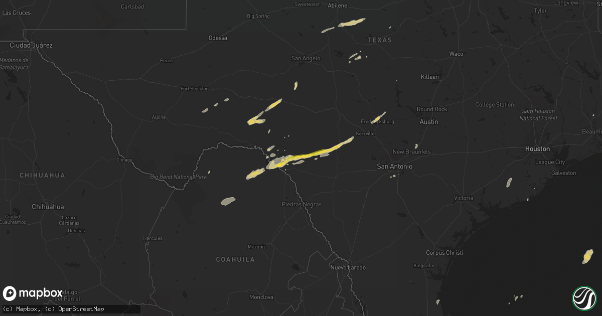
Hail Map on October 30, 2015
Get this storm
October 30 map
$229
one time, instant access
Download today. No call, no setup
Keep the $229
Bought the map and want the full workflow? Apply the entire $229 to a subscription within 7 days. None of it is wasted.
Every map, not just this one
This buys you this map. Subscription and you get every map we run, in the markets you choose from a few cities to whole states to nationwide. Plus real-time alerts the moment a storm fires.
Contact data
Name, contact info, occupancy, even credit band for addresses in the footprint. You go from where it hit to who to call.
Become the source they trust
Unlimited branding weather history reports on demand. You already have the documented answer ready for the property owner, and you are the one who showed up with it.
Property data and RoofTrace estimates
Pull up any address you have got, its value and the exact code rules for that jurisdiction, straight from One Click Code. Then RoofTrace estimates the squares, pitch, and roof value, priced the way you price.
States Impacted by Hail Map on October 30, 2015
Storm reports
Texas
| Date | Description |
|---|---|
| 10/30/20156:50 PM CDT | Several large tree limbs down that are 5 to 10 feet in length. |
| 10/30/20155:50 PM CDT | Several large tree limbs down that are 5 to 10 feet in length. |
| 10/30/20155:41 PM CDT | A local report indicates 61 MPH wind near 4 WSW STERLING CITY |
| 10/30/201512:52 PM CDT | Sheriff and public report of tornado near fm908 and fm316 that became rain wrapped. No report of damage so far. |
| 10/30/20159:52 AM CDT | Delayed report from october 30. Roof damage was reported at several residences along thaxton road. |
| 10/30/20158:28 AM CDT | *** 1 inj *** ef-1 damage...tornado touched down from 728 am to 738 am cdt...2.25 mile path length with 0.25 miles max path width...90 to 100 mph max wind speed. |
| 10/30/20158:11 AM CDT | *** 2 inj *** ef-2 damage...tornado touched down between 711-730 am cdt...8.25 mile path length...0.25 miles max width...111-120 mph max wind speed. |
| 10/30/20158:00 AM CDT | *** 1 inj *** willacy county em reported wind damage at the intersection of fm 490 and fm 1420. Windows were blown out of several cars and the roof was torn off of a mo |
| 10/30/20158:00 AM CDT | Willacy county em reported 7 to 8 structures with roofs blown off and windows broken...as well as several cars damaged from the intersection of fm 490 and 1420 soutwest |
| 10/30/20157:42 AM CDT | Em confirmed modern wood-frame house has multi-directional debris pattern indicative of tornado...formal storm survey tbd. Time estimated from radar. |
| 10/30/20157:16 AM CDT | Several pictures on social media of structure and roof damage in the geronimo and seguin area along huber rd. |
| 10/30/20157:02 AM CDT | Ef-2 damage...tornado touched down between 602 am and 611 am cdt...5.25 mile path length...0.25 mile max path width...120 mph max wind speed. |
| 10/30/20156:50 AM CDT | An ef2 tornado with a path length of 2.25 miles and a path width of 150 yards began near the genoa red bluff and red bluff intersection in pasadena and ended near the |
| 10/30/20156:45 AM CDT | Ef-0 rated tornado briefly touched down near ellington field. |
| 10/30/20156:40 AM CDT | An ef2 tornado with a path length of 2.25 miles and a path width of 150 yards began near the genoa red bluff and red bluff intersection in pasadena and ended near the s |
| 10/30/20156:40 AM CDT | An ef2 tornado with a path length of 2.25 miles and a path width of 150 yards began near the genoa red bluff and red bluff intersection in pasadena and ended near the s |
| 10/30/20156:29 AM CDT | Harris county flood control survey reported an ef-0 tornado caused minor roof damage to a house...snapped several tree trunks half way up the trees...and rolled several |
| 10/30/20156:25 AM CDT | An ef2 tornado with a path length of 3 miles and a path width of 50 yards began at west clover lane and ended north northwest of melody lane. There was extensive tree |
| 10/30/20156:21 AM CDT | *** 2 inj *** an ef0 tornado with a path length of just under 1 mile and a path width of 30 yards began 2 miles northwest of alvin and ended 2 miles north northwest of |
| 10/30/20156:21 AM CDT | *** 2 inj *** an ef-1 tornado with a path length of just under 1 mile and a path width of 30 yards began 2 miles northwest of alvin and ended 2 miles north northwest of |
| 10/30/20156:20 AM CDT | An ef2 tornado with a path length of 3 miles and a path width of 50 yards began at west clover lane and ended north northwest of melody lane. There was extensive tree d |
| 10/30/20156:20 AM CDT | An ef2 tornado with a path length of 3 miles and a path width of 50 yards began at west clover lane and ended north northwest of melody lane. There was extensive tree d |
| 10/30/20156:20 AM CDT | *** 3 inj *** ef-1 tornado tracked along wink road between alvin and manvel and destroyed a mobile home and damaged several others. Damage track may extend further sout |
| 10/30/20156:19 AM CDT | Brief tornado causing ef-1 damage to homes near clear lake city blvd and el dorado blvd from second supercell prior to friendswood la porte tornado. |
| 10/30/20155:53 AM CDT | Power lines downed and some homes damaged in the west side of la porte. Possible tornado. |
| 10/30/20155:48 AM CDT | Heavy damage to a building and power lines down. Possible tornado. |
| 10/30/20155:30 AM CDT | About a dozen of damaged homes in friendswood between fm 2351 and dixie farm road. |
| 10/30/20155:30 AM CDT | Fences down and 12 inch trees snapped in dunbar estates area of friendswood. Possible tornado. |
| 10/30/20155:30 AM CDT | One home experienced a collapsed roof with 30 homes receiving minor damage in friendswood between fm 2351 and dixie farm road. Numerous downed trees and fences. |
| 10/30/20155:30 AM CDT | Report of trees down and some broken windows in the friendswood area. Possible tornado. |
| 10/30/20155:28 AM CDT | Power lines down on lundy lane. |
| 10/30/20155:27 AM CDT | A ef1 tornado with a path length of 3.7 miles and a path width of 50 yards began 3 miles southwest of danbury and ended 2 miles west northwest of danbury. The tornado s |
| 10/30/20155:23 AM CDT | A ef1 tornado with a path length of 3.7 miles and a path width of 50 yards began 3 miles southwest of danbury and ended 2 miles west northwest of danbury. The tornado s |
| 10/30/20155:19 AM CDT | An ef-0 tornado touched down in a field south of town and damaged a cattle handling area... And then tracked into town and did minor damage to trees and structures. The |
| 10/30/20155:17 AM CDT | An ef0 tornado with a path length of just under a mile and a path width of 40 yards began at indian paintbrush drive and ended at the brazos mall in lake jackson. The |
| 10/30/20155:04 AM CDT | An ef0 tornado with a path length of just under a mile and a path width of 40 yards began at indian paintbrush drive and ended at the brazos mall in lake jackson. The t |
| 10/30/20154:58 AM CDT | Tree limbs down and 50 to 60 mph winds on the southeast side of alvin. Possible tornado. |
| 10/30/20154:58 AM CDT | Approximately 25 trailer homes damaged. One trailer home was overturned where two people were injured. Preliminary survey by national weather service confirms it was an |
| 10/30/20154:58 AM CDT | Approximately 25 trailer homes damaged. One trailer home was overturned where two people were injured. Possible tornado. |
| 10/30/20154:29 AM CDT | Ef-1 tornado moved from wildlife management area south of jones creek across route 36 and severely damaged a mobile home. The tornado lifted prior to reaching the brazo |
| 10/30/20154:27 AM CDT | Overturned trailers and possible injuries in the west side of danbury. |
| 10/30/20154:17 AM CDT | Two story house with significant damage. Possible tornado. |
| 10/30/20153:23 AM CDT | Ham operator reported a 61 mph wind gust. With sustained winds between 20 and 45 mph. |
| 10/29/201511:42 PM CDT | Numerous trees down along crabapple road and oakhaven road in north fredericksburg. Social media reports bbq pit tossed and childerns play set destroyed. |
| 10/29/20159:10 PM CDT | A local report indicates 60 MPH wind near 2 N CROSS PLAINS |
| 10/29/20157:42 PM CDT | A local report indicates 66 MPH wind near KICKAPOO CAVERN STATE P |
| 10/29/20157:40 PM CDT | A local report indicates 82 MPH wind near 17 N BRACKETTVILLE |
Cities Impacted by Hail Map on October 30, 2015
- Eldorado, TX
- Leakey, TX
- Eden, TX
- Winters, TX
- Midkiff, TX
- McCamey, TX
- Sheffield, TX
- Fort Stockton, TX
- Bay City, TX
- Del Rio, TX
- Comstock, TX
- Fredericksburg, TX
- Brackettville, TX
- Wharton, TX
- Markham, TX
- Van Vleck, TX
- Hunt, TX
- Camp Wood, TX
- Elmendorf, TX
- Ozona, TX
- Cross Plains, TX
- Cisco, TX
- Rising Star, TX
- Lawn, TX
- Goldsboro, TX
- Clyde, TX
- Ovalo, TX
- Coleman, TX
- Baird, TX
- Santa Anna, TX
- Rochelle, TX
- Lohn, TX
- Rockwood, TX
- Vanderpool, TX
- Barksdale, TX
- Rocksprings, TX
- Uvalde, TX
- Crane, TX
- Big Lake, TX
- Brookesmith, TX
- De Leon, TX
- Willow City, TX
- Medina, TX
- Lampasas, TX
- San Antonio, TX
- Freeport, TX
- Gouldbusk, TX
- Wingate, TX
- New Braunfels, TX
- San Marcos, TX