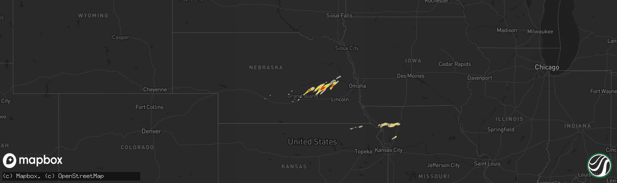
Hail Map on October 29, 2013
The weather event on October 29, 2013 includes Hail map. 3 states and 60 cities were impacted and suffered possible damage. The total estimated number of properties impacted is 3,991.
Want more than just the map?
Turn this storm into a full workflow.
- Owner + property data so you know who to knock
- OnDemand branded weather history reports to win the "did we even have hail?" argument
- RoofTrace estimate so reps stop guessing numbers at the door
Bought this map? Upgrade within 7 days and we'll credit the $230. (10-15 min setup call)
Hail
3,991
Estimated number of impacted properties by a 1.00" hail or larger2,543
Estimated number of impacted properties by a 1.75" hail or larger0
Estimated number of impacted properties by a 2.50" hail or largerStorm reports
Nebraska
| Date | Description |
|---|---|
| 10/29/20136:25 AM CDT | Hail was at least half dollar size. Coop observer went to measure precip around 830 and half dollar size hail was still on the ground. |
| 10/29/20136:20 AM CDT | Golf ball size hail fell right in town. |
| 10/29/20136:15 AM CDT | Hail around half dollar size fell around 615 this morning. The ground was about 50 percent covered. Time estimated from radar. |
| 10/29/20135:55 AM CDT | Report from nebraska rainfall assessment and information network observer. |
Cities Impacted by Hail Map on October 29, 2013
- Amity, MO
- Altamont, MO
- Maysville, MO
- Gallatin, MO
- Pattonsburg, MO
- Winston, MO
- Weatherby, MO
- Clarksdale, MO
- Linwood, NE
- Abie, NE
- David City, NE
- Bruno, NE
- Stromsburg, NE
- Polk, NE
- Osceola, NE
- Brainard, NE
- Prague, NE
- Clarks, NE
- Central City, NE
- Chapman, NE
- Alda, NE
- Wood River, NE
- Rising City, NE
- Shelby, NE
- Benedict, NE
- Bradshaw, NE
- Gresham, NE
- Rockville, NE
- Ravenna, NE
- Savannah, MO
- Helena, MO
- Lathrop, MO
- Centralia, KS
- Rogers, NE
- Bellwood, NE
- Schuyler, NE
- Surprise, NE
- Waco, NE
- York, NE
- Silver Creek, NE
- Morse Bluff, NE
- Union Star, MO
- Rea, MO
- Amazonia, MO
- Sabetha, KS
- Morrill, KS
- Seneca, KS
- Oregon, MO
- Baileyville, KS
- Vermillion, KS
- North Bend, NE
- Ames, NE
- King City, MO
- Saint Joseph, MO
- Columbus, NE
- Shelton, NE
- Holt, MO
- Grand Island, NE
- Hordville, NE
- Cozad, NE