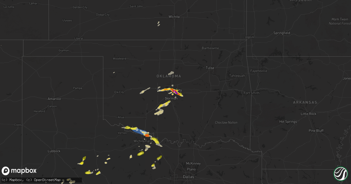
Hail Map on October 23, 2025
Get this storm
October 23 map
$229
one time, instant access
Download today. No call, no setup
Keep the $229
Bought the map and want the full workflow? Apply the entire $229 to a subscription within 7 days. None of it is wasted.
Every map, not just this one
This buys you this map. Subscription and you get every map we run, in the markets you choose from a few cities to whole states to nationwide. Plus real-time alerts the moment a storm fires.
Contact data
Name, contact info, occupancy, even credit band for addresses in the footprint. You go from where it hit to who to call.
Become the source they trust
Unlimited branding weather history reports on demand. You already have the documented answer ready for the property owner, and you are the one who showed up with it.
Property data and RoofTrace estimates
Pull up any address you have got, its value and the exact code rules for that jurisdiction, straight from One Click Code. Then RoofTrace estimates the squares, pitch, and roof value, priced the way you price.
States Impacted by Hail Map on October 23, 2025
Storm reports
Texas
| Date | Description |
|---|---|
| 10/22/20258:18 PM CDT | Mesonet station 77 1sse lomax lomax/howard county measured a 58 mph wind gust caused by thunderstorm outflow. |
| 10/22/20257:45 PM CDT | A local report indicates 1.75 inch wind near 4 WSW Charlie |
| 10/22/20257:35 PM CDT | Mesonet station 84 2wnw tarzan/martin county measured a 63 mph wind gust. |
| 10/22/20257:30 PM CDT | Mesonet station fw9693 pyote measured a 63mph wind gust. |
| 10/22/20257:10 PM CDT | Large tree limb... About 6 to 8 inch diameter... Across the roof of a house. |
Oklahoma
| Date | Description |
|---|---|
| 10/23/20256:40 PM CDT | A local report indicates 60 MPH wind near 3 W Grandfield |
| 10/23/20256:26 PM CDT | Report from mping: quarter |
| 10/23/20256:09 PM CDT | Report from mping: quarter |
| 10/23/20255:59 PM CDT | Report from mping: quarter |
| 10/22/20259:12 PM CDT | A local report indicates 1.00 inch wind near 3 W Dale |
| 10/22/20259:05 PM CDT | Report from mping. |
| 10/22/20259:00 PM CDT | Report from mping. |
| 10/22/20258:48 PM CDT | Report from mping: hen egg+ |
| 10/22/20258:47 PM CDT | A local report indicates 3.00 inch wind near 6 NNW Stella |
| 10/22/20258:34 PM CDT | Report from mping: half dollar |
| 10/22/20258:34 PM CDT | A local report indicates 1.75 inch wind near 3 SSW Nicoma Park |
| 10/22/20258:29 PM CDT | Report from mping: half dollar |
| 10/22/20258:29 PM CDT | Report from mping: golf ball |
| 10/22/20258:28 PM CDT | A local report indicates 2.00 inch wind near 2 ESE Midwest City |
| 10/22/20258:26 PM CDT | A local report indicates 1.50 inch wind near 1 SSW Tinker Air Force |
| 10/22/20258:26 PM CDT | (oun |
| 10/22/20258:25 PM CDT | Report from mping: golf ball |
| 10/22/20258:24 PM CDT | Report from mping: quarter |
| 10/22/20258:19 PM CDT | Report from mping: quarter |
| 10/22/20258:12 PM CDT | Report from mping: quarter |
| 10/22/20258:11 PM CDT | A local report indicates 1.50 inch wind near 2 WSW Forest Park |
| 10/22/20257:47 PM CDT | Report from mping: quarter |
| 10/22/20257:39 PM CDT | Report from mping: quarter |
| 10/22/20257:35 PM CDT | Report from mping. |
| 10/22/20257:34 PM CDT | Report from mping: quarter |
| 10/22/20257:30 PM CDT | A local report indicates 1.75 inch wind near 3 SW Bethany |
Cities Impacted by Hail Map on October 23, 2025
- Covington, OK
- Yeso, NM
- Garita, NM
- Trementina, NM
- Bowie, TX
- Vernon, TX
- Davidson, OK
- Jacksboro, TX
- Chico, TX
- Sunset, TX
- Alvord, TX
- Frederick, OK
- Perrin, TX
- Eunice, NM
- Loveland, OK
- Andrews, TX
- Hollister, OK
- McCaulley, TX
- Holliday, TX
- Windthorst, TX
- Snyder, TX
- Hamlin, TX
- Grandfield, OK
- Crescent, OK
- Guthrie, OK
- Wink, TX
- Raton, NM
- Kermit, TX
- El Reno, OK
- Union City, OK
- Scotland, TX
- Girard, TX
- Rotan, TX
- Devol, OK
- Randlett, OK
- Henrietta, TX
- Wichita Falls, TX
- Gail, TX
- Mulhall, OK
- Yukon, OK
- Spur, TX
- Oklahoma City, OK
- Bethany, OK
- Tarzan, TX
- Pyote, TX
- Sierra Blanca, TX
- Nocona, TX
- Saint Jo, TX
- Byers, TX
- Petrolia, TX
- Stanton, TX
- Archer City, TX
- Coahoma, TX
- Monahans, TX
- Aspermont, TX
- Ira, TX
- Jemez Springs, NM
- Rule, TX
- Spencer, OK
- Fluvanna, TX
- Knox City, TX
- Rochester, TX
- O'Brien, TX
- Odessa, TX
- Midland, TX
- Choctaw, OK
- Harrah, OK
- Newalla, OK
- Ringgold, TX
- Terral, OK
- Mcloud, OK
- Newcastle, TX
- Shawnee, OK
- Olney, TX
- Seymour, TX
- Ryan, OK
- Burkburnett, TX
- Tecumseh, OK
- Big Spring, TX
- Garden City, TX
- Goldsmith, TX
- Gardendale, TX
- Marlow, OK
- Rush Springs, OK
- Ninnekah, OK
- Hydro, OK
- Chickasha, OK
- Bradley, OK
- Hinton, OK
- Alex, OK
- Blanchard, OK
- Norwich, KS
- Kingman, KS
- Spivey, KS
- Lindsay, OK
- Calumet, OK
- Geary, OK
- Purcell, OK
- Edmond, OK
- Washington, OK
- Norman, OK
- Jones, OK
- Arnett, OK