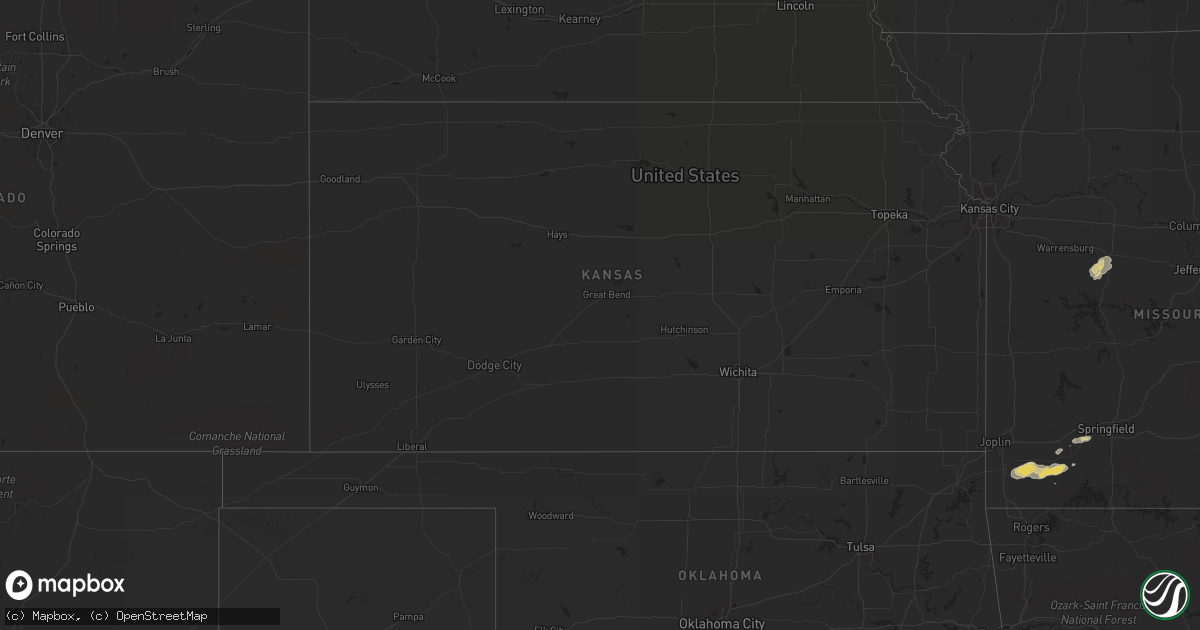
Hail Map on October 22, 2012
Get this storm
October 22 map
$229
one time, instant access
Download today. No call, no setup
Keep the $229
Bought the map and want the full workflow? Apply the entire $229 to a subscription within 7 days. None of it is wasted.
Every map, not just this one
This buys you this map. Subscription and you get every map we run, in the markets you choose from a few cities to whole states to nationwide. Plus real-time alerts the moment a storm fires.
Contact data
Name, contact info, occupancy, even credit band for addresses in the footprint. You go from where it hit to who to call.
Become the source they trust
Unlimited branding weather history reports on demand. You already have the documented answer ready for the property owner, and you are the one who showed up with it.
Property data and RoofTrace estimates
Pull up any address you have got, its value and the exact code rules for that jurisdiction, straight from One Click Code. Then RoofTrace estimates the squares, pitch, and roof value, priced the way you price.
Storm reports
Missouri
| Date | Description |
|---|---|
| 10/22/20122:12 PM CDT | South side of city at intersection of gustine and hartford |
Texas
| Date | Description |
|---|---|
| 10/22/201210:30 AM CDT | Quarter to ping pong sized hail fell in loving. |
| 10/22/201210:25 AM CDT | Golfball sized hail in newcastle. This is a delayed report. |
| 10/22/20127:22 AM CDT | A local report indicates 1.00 inch wind near SNYDER |
California
| Date | Description |
|---|---|
| 10/22/20126:45 PM CDT | The nws storm survey has rated the 10/22/2012 elk grove storm as an ef1 tornado. It touched down near waterman and grant line rds and traveled a distance of about 1 mil |
| 10/22/20126:15 PM CDT | Deputy saw tornado touch down in rice field near spring valley road and joines rd |
| 10/22/20126:10 PM CDT | Tornado touchdown briefly 3 ese of honcut |
| 10/22/20126:10 PM CDT | The nws storm survey has rated the 10/22/2012 browns valley storm as an ef0 tornado. This tornado touched down in a rice field near the intersection of spring valley ro |
| 10/22/20125:30 PM CDT | The nws storm survey team has rated a tornado which occured on 10/22/2012 along rancho rd near olivehurst as an ef1. The estimated path length was a half mile with wind |
| 10/22/20125:08 PM CDT | Sutter co sheriff and fire dept reported tornado at approx 3:08 pm. Reports of power lines down and small structures hit. |
| 10/22/20125:00 PM CDT | The ef1 tornado touched down at the mallard lake golf center along hwy 99 just south of yuba city. It moved ne towards oswald and barry roads and n along railroad ave. |
| 10/21/20127:30 PM CDT | The nws storm survey has rated the 10/22/2012 lake of the pines storm as an ef1 tornado. This tornado touched down near highway 49 at combie road and traveled a distanc |
| 10/21/20127:19 PM CDT | Fire dept reports tornado touch down near lake of the pines area. |
| 10/21/20127:00 PM CDT | Reports of trees down and fences blown in vicinity |
| 10/21/20127:00 PM CDT | Possible tornado. Tree and roof damage reported. |
Illinois
| Date | Description |
|---|---|
| 10/22/201210:27 AM CDT | A local report indicates 1.00 inch wind near WOOD RIVER |
Utah
| Date | Description |
|---|---|
| 10/22/20125:30 PM CDT | Sherwood hills - 5039 ft |
Cities Impacted by Hail Map on October 22, 2012
- Throckmorton, TX
- Snyder, TX
- Ira, TX
- Rockbridge, IL
- Greenfield, IL
- Eldred, IL
- Rosedale, IN
- Brazil, IN
- Loving, TX
- Graham, TX
- Clayton, IL
- Liberty, IL
- Camp Point, IL
- Barry, IL
- Plainville, IL
- Wood River, IL
- Saint Louis, MO
- Roxana, IL
- East Alton, IL
- Hartford, IL
- Bethalto, IL
- Florissant, MO
- South Roxana, IL
- Edwardsville, IL
- Alhambra, IL
- New Douglas, IL
- Worden, IL
- Hamel, IL
- Green Ridge, MO
- Mount Sterling, IL
- Beardstown, IL
- Waggoner, IL
- Farmersville, IL
- Carlinville, IL
- Girard, IL
- Lawn, TX
- Ovalo, TX
- Roodhouse, IL
- Hettick, IL
- Palmyra, IL
- Modesto, IL
- Crane, MO
- Fieldon, IL
- Kane, IL
- Carrollton, IL
- Brighton, IL
- Dow, IL
- Jerseyville, IL
- Elsah, IL
- Godfrey, IL
- Jacksonville, IL
- Mount Vernon, MO
- Billings, MO
- Republic, MO
- Marionville, MO
- Medora, IL
- Olney, TX
- Newcastle, TX
- Alton, IL
- West Alton, MO
- Pittsfield, IL
- Pleasant Hill, IL
- Bryson, TX
- Virden, IL
- White Hall, IL
- Wingate, TX
- Blackwell, TX
- Arenzville, IL
- Rockport, IL
- Hull, IL
- Kinderhook, IL
- Alexander, IL
- Winchester, IL
- Baylis, IL
- Griggsville, IL
- Ashland, IL
- Franklin, IL
- New Canton, IL
- Ashburn, MO
- Concord, IL
- Murrayville, IL
- Bluffs, IL
- Woodson, IL
- Meredosia, IL
- Louisiana, MO
- New London, MO
- New Salem, IL
- Chapin, IL
- Green Valley, IL
- San Jose, IL
- Winters, TX
- Bronte, TX
- Tuscola, TX
- McLean, IL
- Atlanta, IL
- Chesterfield, IL
- Strasburg, IL
- Windsor, IL
- Maryneal, TX
- Stark City, MO
- Stella, MO
- Fairview, MO
- Granby, MO
- Argenta, IL
- Nebo, IL
- Pearl, IL
- Millstadt, IL
- Belleville, IL
- Saint Jacob, IL
- Troy, IL
- Fairview Heights, IL
- Highland, IL
- O'Fallon, IL
- Caseyville, IL
- Collinsville, IL
- Marine, IL
- Auburn, IL
- Thayer, IL
- Divernon, IL
- Owaneco, IL
- Pana, IL
- Westbrook, TX
- Baird, TX
- Albany, TX
- Granite City, IL
- High Ridge, MO
- Timewell, IL
- Rushville, IL
- Payson, IL
- Versailles, IL
- Clyde, TX
- Goldsboro, TX
- Windfall, IN
- Elwood, IN
- Windthorst, TX
- Windsor, MO
- Glenarm, IL
- Harvel, IL
- Pawnee, IL
- Morrisonville, IL
- Imperial, MO
- Fenton, MO
- Arnold, MO
- Colorado City, TX
- Woodson, TX
- Big Spring, TX
- Litchfield, IL
- Garden City, TX
- Russiaville, IN
- Kempton, IN
- Fidelity, IL
- Virginia, IL
- Neosho, MO
- Aurora, MO
- Purdy, MO
- Verona, MO
- Pierce City, MO
- Monett, MO
- Decatur, IL
- Sedalia, MO
- Pleasant Plains, IL
- Sullivan, IL
- Lincoln, MO
- Ionia, MO
- Sorento, IL
- Findlay, IL
- Shelbyville, IL
- Rocky Comfort, MO
- Wheaton, MO
- New Berlin, IL
- Roby, TX
- Shobonier, IL
- Wrights, IL
- Raymond, IL
- Nokomis, IL
- Rochester, IL
- Grafton, IL
- Shipman, IL
- Nilwood, IL
- Ferris, TX
- Hermleigh, TX
- Dupo, IL
- East Saint Louis, IL
- East Carondelet, IL
- Tower Hill, IL
- Farmer City, IL
- Canton, IL
- Paris, IL
- Taylorville, IL
- Kincaid, IL
- Hillsboro, IL
- Walshville, IL
- Butler, IL
- Waynesville, IL
- Mackinaw, IL
- Hopedale, IL
- Tremont, IL
- Bowie, TX
- Mora, MO
- Lueders, TX
- Robert Lee, TX
- Avon, IL
- Chambersburg, IL
- Rotan, TX
- Hamburg, IL
- Abilene, TX
- Mahomet, IL
- Hillview, IL
- Frankford, MO
- Kampsville, IL
- Trenton, IL
- Coahoma, TX
- Cross Plains, TX
- Donnellson, IL
- Greenville, IL
- Lebanon, IL
- Maryville, IL
- Benld, IL
- Glen Carbon, IL
- Sawyerville, IL
- Cottage Hills, IL
- Scott Air Force Base, IL
- Pocahontas, IL
- Gillespie, IL
- Wilsonville, IL
- Livingston, IL
- Dorsey, IL
- Bunker Hill, IL
- Staunton, IL
- Mount Olive, IL
- Moro, IL
- Sharpsville, IN
- Tipton, IN
- Sterling City, TX
- Macon, IL
- Moweaqua, IL
- Dewitt, IL
- Weldon, IL
- Clinton, IL
- Breckenridge, TX
- Monticello, IA
- Emden, IL
- Mason City, IL
- New Holland, IL
- Greenview, IL
- Middletown, IL
- Good Hope, IL
- Bushnell, IL
- Prairie City, IL
- Cisco, TX