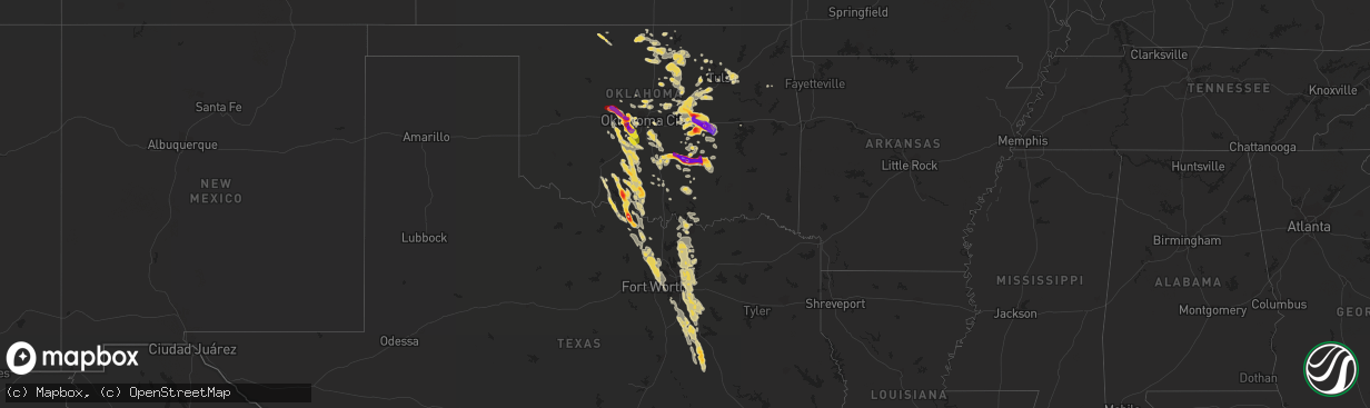
Hail Map on October 22, 2011
The weather event on October 22, 2011 includes Hail map. 2 states and 260 cities were impacted and suffered possible damage. The total estimated number of properties impacted is 14,390.
Want more than just the map?
Turn this storm into a full workflow.
- Owner + property data so you know who to knock
- OnDemand branded weather history reports to win the "did we even have hail?" argument
- RoofTrace estimate so reps stop guessing numbers at the door
Bought this map? Upgrade within 7 days and we'll credit the $230. (10-15 min setup call)
Hail
14,390
Estimated number of impacted properties by a 1.00" hail or larger13,615
Estimated number of impacted properties by a 1.75" hail or larger16,103
Estimated number of impacted properties by a 2.50" hail or largerStorm reports
Texas
| Date | Description |
|---|---|
| 10/22/20113:30 AM CDT | Quarter size hail just south of rice. |
| 10/22/20112:54 AM CDT | A local report indicates 1.00 inch wind near GARRETT |
| 10/22/20112:35 AM CDT | A local report indicates 1.00 inch wind near BRISTOL |
| 10/22/20111:58 AM CDT | 50-foot tree three feet in diameter downed on a house. |
| 10/22/20111:53 AM CDT | Ground completely covered with hail a couple inches deep. Largest hailstones were quarter size. |
| 10/22/20111:50 AM CDT | Limbs up to 5 inches in diameter knocked down and large hail covering the groud. |
| 10/22/20111:48 AM CDT | Reported in rowlett |
| 10/22/20111:45 AM CDT | Quarter hail fell for five minutes...ending at 0150 cdt and damaging a skylight. |
| 10/22/20111:39 AM CDT | Reported at intersection of shiloh and buckingham. |
| 10/22/20111:21 AM CDT | Reported at spring creek and coit road. |
| 10/22/201112:20 AM CDT | Roofs blown off at fire dept and another building downtown. Trees down as well. |
| 10/22/201112:10 AM CDT | Large tree limbs down on highway 37 south just out of the clarksville city limits. |
| 10/22/201112:10 AM CDT | Large tree limbs were down and blocking fairgrounds road in clarksville. |
| 10/21/201111:55 PM CDT | Cox field awos reported a wind gust to 59 mph. |
| 10/21/201111:54 PM CDT | Golfball size hail reported at nocona general hospital. |
| 10/21/201111:40 PM CDT | 18 wheeler blown over in bonham...bonham airport reported 55 mph wind gust. |
| 10/21/201111:37 PM CDT | Gray road and fm 2849...5 nw of nocona |
Oklahoma
| Date | Description |
|---|---|
| 10/22/20116:58 PM CDT | A local report indicates 1.50 inch wind near 4 W YUKON |
| 10/22/20116:55 PM CDT | A local report indicates 2.00 inch wind near 2 NNE BEARDEN |
| 10/22/20116:50 PM CDT | Windshield damage was reported to several vehicles. |
| 10/22/20116:45 PM CDT | The roof of a barn was blown off.trees and power lines were blown down. |
| 10/22/20116:41 PM CDT | A local report indicates 2.75 inch wind near 3 W BOLEY |
| 10/22/20116:39 PM CDT | A local report indicates 63 MPH wind near 4 SE BILLINGS |
| 10/22/20116:29 PM CDT | A local report indicates 1.25 inch wind near 3 NE CONCHO |
| 10/22/20116:27 PM CDT | A local report indicates 1.75 inch wind near 5 S ASHER |
| 10/22/20116:27 PM CDT | A local report indicates 1.75 inch wind near 4 NNE BOLEY |
| 10/22/20116:19 PM CDT | A local report indicates 1.50 inch wind near 2 S WANETTE |
| 10/22/20115:50 PM CDT | Reported by koco-tv. |
| 10/22/20114:51 PM CDT | A local report indicates 1.00 inch wind near 1 SW PONCA CITY |
| 10/21/201111:55 PM CDT | Measured at the idabel mesonet station. |
| 10/21/201111:35 PM CDT | Power pole and lines down. Several trees blown down along with a tree on a vehicle. |
| 10/21/201111:25 PM CDT | A pick-up truck had several dents from the large hail. |
| 10/21/201111:10 PM CDT | A local report indicates 67 MPH wind near 2 NW HUGO |
| 10/21/201111:10 PM CDT | Two 8-10 inch diameter trees blown down by thunderstorm wind gusts |
| 10/21/201110:35 PM CDT | A local report indicates 2.50 inch wind near ADDINGTON |
| 10/21/201110:35 PM CDT | A local report indicates 1.00 inch wind near 1 N ADDINGTON |
| 10/21/201110:20 PM CDT | A local report indicates 1.00 inch wind near 7 NNW HEALDTON |
| 10/21/201110:17 PM CDT | A local report indicates 1.75 inch wind near 5 ESE LOCO |
| 10/21/201110:15 PM CDT | A local report indicates 1.00 inch wind near 3 SW DUNCAN |
| 10/21/20119:48 PM CDT | Large tree downed |
| 10/21/20119:45 PM CDT | A local report indicates 1.00 inch wind near 10 NNE COALGATE |
| 10/21/20119:25 PM CDT | A local report indicates 60 MPH wind near PAULS VALLEY |
| 10/21/20119:13 PM CDT | Large tree limbs downed |
| 10/21/20118:58 PM CDT | A local report indicates 1.00 inch wind near 11 E MARLOW |
| 10/21/20118:50 PM CDT | A local report indicates 1.75 inch wind near GERTY |
| 10/21/20118:45 PM CDT | The hail was reported at se 15th and westminster. |
| 10/21/20118:27 PM CDT | A local report indicates 1.75 inch wind near ALLEN |
| 10/21/20118:15 PM CDT | A local report indicates 1.25 inch wind near 3 S BLANCHARD |
| 10/21/20118:05 PM CDT | A local report indicates 1.00 inch wind near 2 WSW BLANCHARD |
| 10/21/20118:00 PM CDT | A local report indicates 1.25 inch wind near 9 E NORMAN |
| 10/21/20117:53 PM CDT | A local report indicates 2.75 inch wind near 3 NNW ADA |
| 10/21/20117:50 PM CDT | A local report indicates 1.00 inch wind near 5 WSW POCASSET |
| 10/21/20117:50 PM CDT | A local report indicates 1.25 inch wind near 2 N STROUD |
| 10/21/20117:45 PM CDT | A local report indicates 69 MPH wind near 4 W HECTORVILLE |
| 10/21/20117:40 PM CDT | A local report indicates 1.25 inch wind near 6 E TUTTLE |
| 10/21/20117:40 PM CDT | A local report indicates 71 MPH wind near 4 W HECTORVILLE |
| 10/21/20117:29 PM CDT | A local report indicates 1.00 inch wind near CATOOSA |
| 10/21/20117:28 PM CDT | A local report indicates 2.00 inch wind near TUTTLE |
| 10/21/20117:20 PM CDT | A local report indicates 3.00 inch wind near 2 NE ADA |
| 10/21/20117:20 PM CDT | A local report indicates 2.75 inch wind near 3 NNW ADA |
| 10/21/20117:20 PM CDT | Possibly as big as a softball |
| 10/21/20117:20 PM CDT | A local report indicates 1.00 inch wind near 2 NW WARR ACRES |
| 10/21/20117:20 PM CDT | Significant hail damage to car. The windshield was busted out. |
| 10/21/20117:15 PM CDT | A local report indicates 1.75 inch wind near 3 W ADA |
| 10/21/20117:10 PM CDT | A local report indicates 1.00 inch wind near 5 N MUSTANG |
| 10/21/20117:10 PM CDT | Emergency manager reported trees and power lines down in and south of town |
| 10/21/20117:08 PM CDT | Car windshields were shattered from the hail. |
| 10/21/20117:05 PM CDT | A local report indicates 2.75 inch wind near 7 NW ADA |
| 10/21/20117:00 PM CDT | The hail fell near sw 36th and banner road. The hail was reported by kfor-tv. |
Cities Impacted by Hail Map on October 22, 2011
- Walters, OK
- Geronimo, OK
- Prague, OK
- Ponca City, OK
- Tishomingo, OK
- Mill Creek, OK
- Tonkawa, OK
- Medford, OK
- Deer Creek, OK
- Lamont, OK
- Nardin, OK
- Blackwell, OK
- Okemah, OK
- Jewett, TX
- Groesbeck, TX
- Teague, TX
- Mexia, TX
- Sasakwa, OK
- Wewoka, OK
- Chandler, OK
- Cleveland, OK
- Howe, TX
- Sherman, TX
- Morrison, OK
- Pawnee, OK
- Glencoe, OK
- Pauls Valley, OK
- Paoli, OK
- Davis, OK
- Crescent, OK
- Wetumka, OK
- Holdenville, OK
- Hominy, OK
- Burlington, OK
- Cherokee, OK
- Jet, OK
- Blooming Grove, TX
- Marlow, OK
- Ringling, OK
- Duncan, OK
- Healdton, OK
- Chickasha, OK
- Lindsay, OK
- Ninnekah, OK
- Blanchard, OK
- Graham, OK
- Alex, OK
- Bradley, OK
- Comanche, OK
- Loco, OK
- Rush Springs, OK
- Oklahoma City, OK
- Yukon, OK
- Bethany, OK
- Ada, OK
- Stratford, OK
- Pottsboro, TX
- Kingston, OK
- Luther, OK
- Maud, OK
- Konawa, OK
- Skiatook, OK
- Meeker, OK
- Davenport, OK
- Seminole, OK
- Castle, OK
- Dustin, OK
- Boley, OK
- Weleetka, OK
- Earlsboro, OK
- Stroud, OK
- Sparks, OK
- Depew, OK
- Paden, OK
- Shawnee, OK
- Cushing, OK
- Stillwater, OK
- Perkins, OK
- Coyle, OK
- Waurika, OK
- Allen, TX
- Tulsa, OK
- Broken Arrow, OK
- Coalgate, OK
- Wayne, OK
- Calvin, OK
- Allen, OK
- Centrahoma, OK
- Byars, OK
- Ryan, OK
- Nocona, TX
- Ferris, TX
- Ennis, TX
- Norman, OK
- Noble, OK
- Wellston, OK
- Purdon, TX
- Barry, TX
- Corsicana, TX
- El Reno, OK
- Mustang, OK
- Union City, OK
- Tuttle, OK
- Minco, OK
- Wanette, OK
- Lexington, OK
- Temple, OK
- Byers, TX
- Catoosa, OK
- Geary, OK
- Calumet, OK
- Okarche, OK
- Edmond, OK
- Saint Jo, TX
- Mckinney, TX
- Guthrie, OK
- Bristow, OK
- Kellyville, OK
- Carney, OK
- Tryon, OK
- Beggs, OK
- Sapulpa, OK
- Sand Springs, OK
- Waxahachie, TX
- Frost, TX
- Thornton, TX
- Dawson, TX
- Italy, TX
- Marquez, TX
- Richland, TX
- Donie, TX
- Coolidge, TX
- Wortham, TX
- Forreston, TX
- Fairfax, OK
- Ralston, OK
- Lawton, OK
- Fort Worth, TX
- North Richland Hills, TX
- Argyle, TX
- Rhome, TX
- Justin, TX
- Roanoke, TX
- Keller, TX
- Southlake, TX
- Haslet, TX
- Denton, TX
- Decatur, TX
- Ponder, TX
- Dallas, TX
- Richardson, TX
- Newkirk, OK
- Princeton, TX
- Barnsdall, OK
- Garland, TX
- Forestburg, TX
- Mesquite, TX
- Prosper, TX
- Wilmer, TX
- Palmer, TX
- Tioga, TX
- Collinsville, TX
- Celina, TX
- Pilot Point, TX
- Chatfield, TX
- Frisco, TX
- Rockwall, TX
- Sachse, TX
- Sunnyvale, TX
- Anna, TX
- Rice, TX
- Plano, TX
- Wylie, TX
- Lancaster, TX
- Rowlett, TX
- Kemp, TX
- Seagoville, TX
- Rosser, TX
- Balch Springs, TX
- Forney, TX
- Red Oak, TX
- Hutchins, TX
- Scurry, TX
- Gunter, TX
- Stonewall, OK
- Roff, OK
- Choctaw, OK
- Billings, OK
- Garber, OK
- Perry, OK
- Red Rock, OK
- Hinton, OK
- Whitesboro, TX
- Van Alstyne, TX
- Ratliff City, OK
- Wilson, OK
- Foster, OK
- Pocasset, OK
- Purcell, OK
- Newcastle, OK
- Amber, OK
- Wheatland, OK
- Braman, OK
- Arcadia, OK
- Marland, OK
- Terlton, OK
- Mannford, OK
- Denison, TX
- Wynona, OK
- Fitzhugh, OK
- Fittstown, OK
- Ripley, OK
- Ardmore, OK
- Hurst, TX
- Arlington, TX
- Krum, TX
- Springer, OK
- Tahlequah, OK
- Stuart, OK
- Owasso, OK
- Claremore, OK
- Midlothian, TX
- Calera, OK
- Mead, OK
- Cartwright, OK
- Colbert, OK
- Kingfisher, OK
- Jennings, OK
- Drumright, OK
- Henrietta, TX
- Anadarko, OK
- Alvord, TX
- Montague, TX
- Sunset, TX
- Bowie, TX
- Ringgold, TX
- Terral, OK
- Lamar, OK
- Osage, OK
- Elmore City, OK
- Wynnewood, OK
- Sperry, OK
- Hulbert, OK
- Melissa, TX
- Milburn, OK
- Yale, OK
- Gracemont, OK
- Washington, OK
- Maramec, OK
- Atwood, OK
- Gainesville, TX
- Bedford, TX
- Euless, TX
- Grapevine, TX
- Colleyville, TX
- Cedar Hill, TX
- Sadler, TX
- Gordonville, TX
- Maysville, OK
- Piedmont, OK