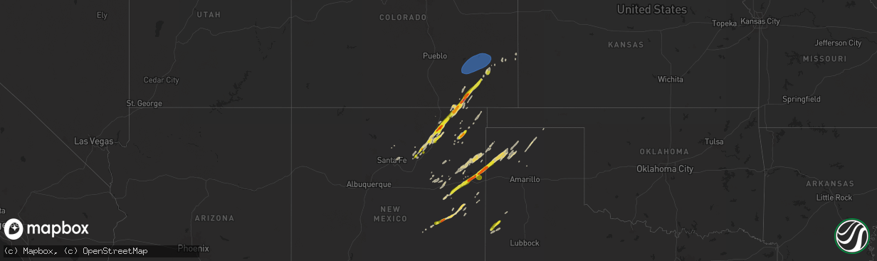
Hail Map on October 20, 2024
The weather event on October 20, 2024 includes Hail and Wind maps. 4 states and 67 cities were impacted and suffered possible damage. The total estimated number of properties impacted is 1,767.
Want more than just the map?
Turn this storm into a full workflow.
- Owner + property data so you know who to knock
- OnDemand branded weather history reports to win the "did we even have hail?" argument
- RoofTrace estimate so reps stop guessing numbers at the door
Bought this map? Upgrade within 7 days and we'll credit the $230. (10-15 min setup call)
Hail
Wind
1,767
Estimated number of impacted properties by a 1.00" hail or larger141
Estimated number of impacted properties by a 1.75" hail or larger0
Estimated number of impacted properties by a 2.50" hail or largerStates Impacted by Hail Map on October 20, 2024
Storm reports
New Mexico
| Date | Description |
|---|---|
| 10/20/202412:30 AM CDT | Hail lasted for 15-20 minutes. |
| 10/20/202412:08 AM CDT | A local report indicates 1.75 inch wind near 12 E Tucumcari |
| 10/19/202411:58 PM CDT | Penny to quarter size hail stripped trees of their leaves with 35 mph wind gusts. |
| 10/19/202410:13 PM CDT | A local report indicates 60 MPH wind near 13 SW Melrose |
Texas
| Date | Description |
|---|---|
| 10/20/20246:05 AM CDT | Measured by a personal weather station. Time estimated from radar. |
| 10/20/20246:03 AM CDT | Media relayed photo of quarter size hail northwest of sudan and damage to vinyl siding due to wind-driven hail. Time estimated from radar. |
Colorado
| Date | Description |
|---|---|
| 10/20/20241:00 AM CDT | Personal weather station kcocheye2. |
| 10/19/202411:23 PM CDT | Asos station klhx la junta airport. |
| 10/19/202411:01 PM CDT | Neighbor |
| 10/19/202410:20 PM CDT | Hailstones were fused together... Some nearly the size of a golf ball in width. |
Cities Impacted by Hail Map on October 20, 2024
- Sapello, NM
- Ocate, NM
- Las Vegas, NM
- Wagon Mound, NM
- Branson, CO
- Folsom, NM
- Des Moines, NM
- Raton, NM
- Springer, NM
- Chimayo, NM
- Yeso, NM
- Fort Sumner, NM
- Trinchera, CO
- Taiban, NM
- Melrose, NM
- Mosquero, NM
- Conchas Dam, NM
- Floyd, NM
- Cuervo, NM
- Buena Vista, NM
- House, NM
- Kim, CO
- Grady, NM
- Newkirk, NM
- Tucumcari, NM
- Broadview, NM
- Las Animas, CO
- San Jon, NM
- Bard, NM
- Gladstone, NM
- Grenville, NM
- Logan, NM
- Lamar, CO
- Holly, CO
- Hartley, TX
- Channing, TX
- Sheridan Lake, CO
- Santa Rosa, NM
- Garita, NM
- Nara Visa, NM
- Amistad, NM
- Dalhart, TX
- Stratford, TX
- Dumas, TX
- Sunray, TX
- Gruver, TX
- Muleshoe, TX
- Sudan, TX
- Enochs, TX
- Amherst, TX
- Dimmitt, TX
- Earth, TX
- Roy, NM
- Rocky Ford, CO
- Cheraw, CO
- La Junta, CO
- Swink, CO
- Arlington, CO
- Haswell, CO
- Hasty, CO
- McClave, CO
- Adrian, TX
- Cheyenne Wells, CO
- Kit Carson, CO
- Arapahoe, CO
- Weskan, KS
- Burlington, CO