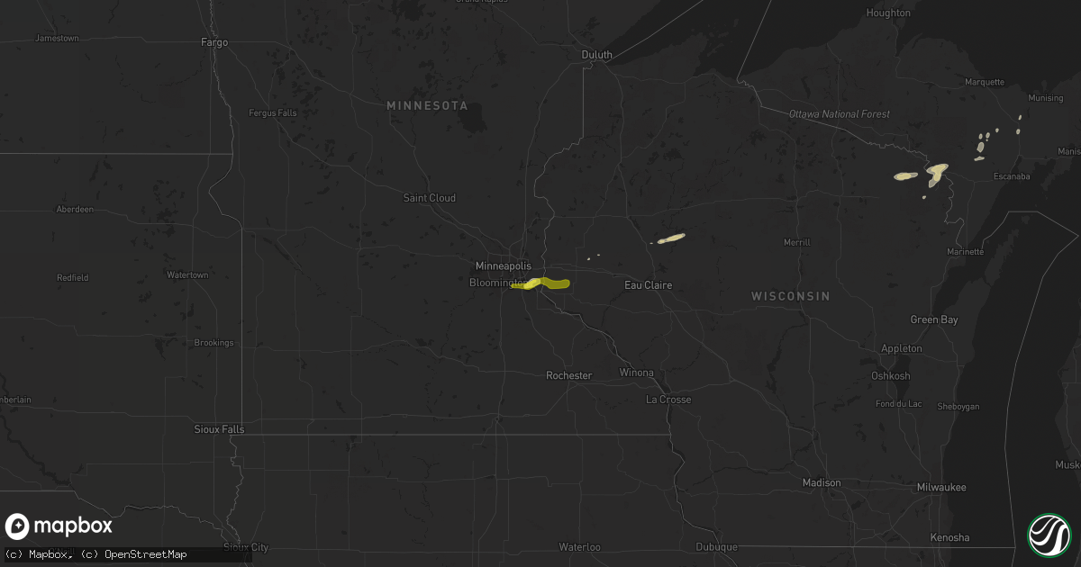
Hail Map on October 17, 2016
Get this storm
October 17 map
$229
one time, instant access
Download today. No call, no setup
Keep the $229
Bought the map and want the full workflow? Apply the entire $229 to a subscription within 7 days. None of it is wasted.
Every map, not just this one
This buys you this map. Subscription and you get every map we run, in the markets you choose from a few cities to whole states to nationwide. Plus real-time alerts the moment a storm fires.
Contact data
Name, contact info, occupancy, even credit band for addresses in the footprint. You go from where it hit to who to call.
Become the source they trust
Unlimited branding weather history reports on demand. You already have the documented answer ready for the property owner, and you are the one who showed up with it.
Property data and RoofTrace estimates
Pull up any address you have got, its value and the exact code rules for that jurisdiction, straight from One Click Code. Then RoofTrace estimates the squares, pitch, and roof value, priced the way you price.
Storm reports
New York
| Date | Description |
|---|---|
| 10/17/20166:59 PM CDT | Tree blocking roadway near intersection of barber road and eldred road. |
| 10/17/20166:57 PM CDT | Tree blocking roadway. |
| 10/16/20167:03 PM CDT | Tree blocking roadway near intersection of state route 13 and lake wood road. |
Wisconsin
| Date | Description |
|---|---|
| 10/17/20166:43 PM CDT | Reports of trees and power lines down in rhinelander towards eagle river. Time estimated via radar |
Michigan
| Date | Description |
|---|---|
| 10/17/20169:31 AM CDT | Delayed report. Time estimated via radar. |
| 10/17/20169:31 AM CDT | . |
| 10/17/20167:24 AM CDT | . |
| 10/17/20167:12 AM CDT | Multiple trees and power lines down. Time estimated by radar. |
| 10/17/20167:00 AM CDT | . |
Cities Impacted by Hail Map on October 17, 2016
- Engadine, MI
- Lincoln, MI
- Ellsworth, MI
- Roscommon, MI
- Boyne Falls, MI
- Kewadin, MI
- Bellaire, MI
- East Jordan, MI
- Boyne City, MI
- Central Lake, MI
- River Falls, WI
- Prescott, WI
- Beldenville, WI
- Hastings, MN
- Cottage Grove, MN
- Saint Paul Park, MN
- Bark River, MI
- Little Lake, MI
- Saint Ignace, MI
- Perronville, MI
- Moran, MI
- Bloomer, WI
- New Auburn, WI
- Ridgeland, WI
- Colfax, WI
- Harrisville, MI
- Mikado, MI
- Glennie, MI
- Hale, MI
- South Branch, MI
- Glenwood City, WI
- Kingsford, MI
- Vulcan, MI
- Fence, WI
- Niagara, WI
- Iron Mountain, MI
- Cornell, MI
- Florence, WI
- Pembine, WI
- Armstrong Creek, WI
- Norway, MI
- Quinnesec, MI
- Goodman, WI
- Hermansville, MI
- Kalkaska, MI
- South Boardman, MI
- Fife Lake, MI
- Lupton, MI
- Rose City, MI
- Long Lake, MI
- Lachine, MI
- Hessel, MI
- Curtis, MI
- Germfask, MI
- Naubinway, MI
- Newberry, MI
- Gould City, MI
- Mio, MI
- Barton City, MI
- Curran, MI
- Herron, MI
- Greenbush, MI
- Cornell, WI
- Holcombe, WI
- Elmira, MI
- Mancelona, MI
- Charlevoix, MI
- West Branch, MI
- Trenary, MI
- Millersburg, MI
- Rapid River, MI
- Dunbar, WI
- Onaway, MI
- Rock, MI
- Petoskey, MI
- Wheeler, WI
- Saint Paul, MN
- Afton, MN
- Lake City, MI
- Luzerne, MI
- Inver Grove Heights, MN
- Ellsworth, WI
- Lake Ann, MI