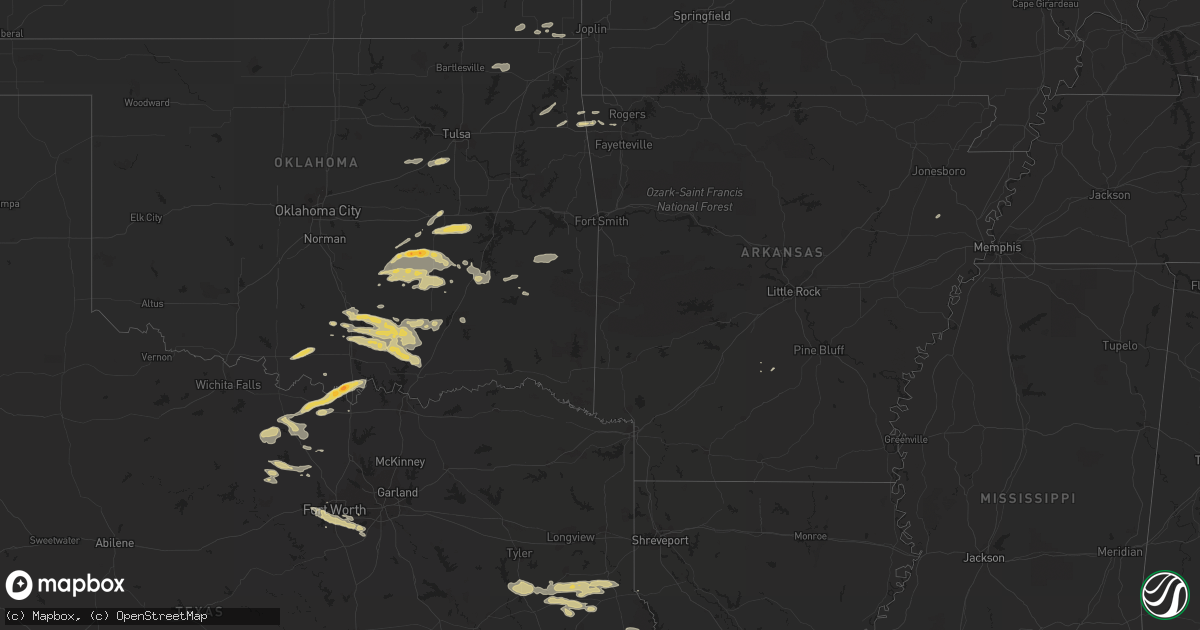
Hail Map on October 17, 2011
Get this storm
October 17 map
$229
one time, instant access
Download today. No call, no setup
Keep the $229
Bought the map and want the full workflow? Apply the entire $229 to a subscription within 7 days. None of it is wasted.
Every map, not just this one
This buys you this map. Subscription and you get every map we run, in the markets you choose from a few cities to whole states to nationwide. Plus real-time alerts the moment a storm fires.
Contact data
Name, contact info, occupancy, even credit band for addresses in the footprint. You go from where it hit to who to call.
Become the source they trust
Unlimited branding weather history reports on demand. You already have the documented answer ready for the property owner, and you are the one who showed up with it.
Property data and RoofTrace estimates
Pull up any address you have got, its value and the exact code rules for that jurisdiction, straight from One Click Code. Then RoofTrace estimates the squares, pitch, and roof value, priced the way you price.
Storm reports
Oklahoma
| Date | Description |
|---|---|
| 10/16/20118:45 PM CDT | A local report indicates 1.00 inch wind near 3 W ATOKA |
| 10/16/20118:19 PM CDT | A local report indicates 1.00 inch wind near 4 W NIDA |
| 10/16/20118:14 PM CDT | A local report indicates 1.00 inch wind near 4 SW MARIETTA |
| 10/16/20117:55 PM CDT | Dime-size hail was also reported. |
| 10/16/20117:15 PM CDT | Dime to quarter sized hail reported |
| 10/16/20117:10 PM CDT | A local report indicates 1.00 inch wind near DAVIS |
| 10/16/20117:03 PM CDT | Delayed report from motorist north of holdenville |
Texas
| Date | Description |
|---|---|
| 10/17/20113:00 AM CDT | Numerous trees down near the intersection of fm 1971 and fm 999. |
| 10/17/20112:45 AM CDT | Large tree down on hwy 315. |
| 10/17/20112:34 AM CDT | Trees down in minden tx. |
| 10/16/201111:25 PM CDT | Dime to quarter sized hail was reported in north mansfield. |
| 10/16/201111:20 PM CDT | Quarter size hail 1 mile northeast of edgecliff |
| 10/16/20119:05 PM CDT | Rsois observation |
| 10/16/20119:00 PM CDT | Fort worth meacham asos |
| 10/16/20118:14 PM CDT | A local report indicates 1.00 inch wind near 5 SW MARIETTA |
| 10/16/20118:06 PM CDT | Golfball hail in sivells bend |
Louisiana
| Date | Description |
|---|---|
| 10/17/20114:30 AM CDT | Tree down along hwy. 6 and 476 near negreet. |
| 10/17/20114:15 AM CDT | Tree down on springhill church road. |
| 10/17/20114:10 AM CDT | Several trees down on hwy 163. |
Cities Impacted by Hail Map on October 17, 2011
- Milburn, OK
- Tishomingo, OK
- Wewoka, OK
- Holdenville, OK
- Roff, OK
- Mcalester, OK
- Saint Jo, TX
- Muenster, TX
- Gainesville, TX
- Marietta, OK
- Jacksboro, TX
- Bridgeport, TX
- Perrin, TX
- Stonewall, OK
- Atoka, OK
- Tupelo, OK
- Wapanucka, OK
- Coalgate, OK
- Mannsville, OK
- Mill Creek, OK
- Ardmore, OK
- Talihina, OK
- Ringling, OK
- Ryan, OK
- Fort Worth, TX
- Hartshorne, OK
- Springdale, AR
- Bentonville, AR
- Jacksonville, TX
- Henryetta, OK
- Weleetka, OK
- Eufaula, OK
- Dustin, OK
- Wetumka, OK
- Springer, OK
- Madill, OK
- Kenefic, OK
- Durant, OK
- Bullard, TX
- Bristow, OK
- Depew, OK
- Mount Enterprise, TX
- Nacogdoches, TX
- Laneville, TX
- Reklaw, TX
- Cushing, TX
- Nowata, OK
- Vinita, OK
- Delaware, OK
- Okemah, OK
- Whitt, TX
- Poolville, TX
- Stuart, OK
- Atwood, OK
- Ada, OK
- Calvin, OK
- Sasakwa, OK
- Konawa, OK
- Allen, OK
- Healdton, OK
- San Augustine, TX
- Shelbyville, TX
- Center, TX
- Sulphur, OK
- Red Oak, OK
- Sunset, TX
- Bowie, TX
- Troup, TX
- Hanna, OK
- Mansfield, TX
- Garrison, TX
- Grand Prairie, TX
- Arlington, TX
- Kennedale, TX
- Midlothian, TX
- Cedar Hill, TX
- Aledo, TX
- Coleman, OK
- Dougherty, OK
- Davis, OK
- Wynnewood, OK
- Maud, OK
- Sapulpa, OK
- Kellyville, OK
- Paradise, TX
- Mounds, OK
- Kiefer, OK
- Carthage, AR
- Baxter Springs, KS
- Columbus, KS
- Henderson, TX
- Long Branch, TX
- Montague, TX
- Burneyville, OK
- Nocona, TX
- Pittsburg, KS
- Girard, KS
- Bellevue, TX
- Alvord, TX
- Forestburg, TX
- Edna, KS
- Bartlett, KS
- Tenaha, TX
- Carthage, TX
- Timpson, TX
- Gary, TX
- Stringtown, OK
- Leola, AR
- Gentry, AR
- Siloam Springs, AR
- Colcord, OK
- Wilburton, OK
- Kansas, OK
- Rose, OK
- Cave Springs, AR
- Lowell, AR
- Hennepin, OK
- Decatur, TX
- Decatur, AR
- Cherry Valley, AR
- Chetopa, KS
- Mccurtain, OK
- Bokoshe, OK
- Jay, OK
- Maysville, AR
- Oswego, KS
- Frankston, TX
- Spavinaw, OK
- Eucha, OK
- Salina, OK
- Boyd, TX
- Seminole, OK
- Logansport, LA
- Lamar, OK
- Stratford, OK
- Wilson, OK