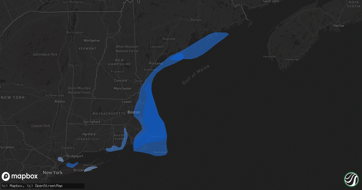
Hail Map on October 16, 2019
Get this storm
October 16 map
$229
one time, instant access
Download today. No call, no setup
Keep the $229
Bought the map and want the full workflow? Apply the entire $229 to a subscription within 7 days. None of it is wasted.
Every map, not just this one
This buys you this map. Subscription and you get every map we run, in the markets you choose from a few cities to whole states to nationwide. Plus real-time alerts the moment a storm fires.
Contact data
Name, contact info, occupancy, even credit band for addresses in the footprint. You go from where it hit to who to call.
Become the source they trust
Unlimited branding weather history reports on demand. You already have the documented answer ready for the property owner, and you are the one who showed up with it.
Property data and RoofTrace estimates
Pull up any address you have got, its value and the exact code rules for that jurisdiction, straight from One Click Code. Then RoofTrace estimates the squares, pitch, and roof value, priced the way you price.
States Impacted by Hail Map on October 16, 2019
Storm reports
New York
| Date | Description |
|---|---|
| 10/16/20195:56 AM CDT | At 1055 PM EDT, a band of showers and isolated thunderstorms capable of producing damaging winds was located along a line extending from 13 miles south of Southampton to 8 miles south of East Hampton to 22 miles southeast of Hither Hills State Park, moving north at 40 mph. HAZARD...60 mph wind gusts. SOURCE...Radar indicated. IMPACT...Expect damage to trees and power lines. This band of showers with intense winds will be near... East Hampton around 1105 PM EDT. Hither Hills State Park around 1115 PM EDT. Gardiners Island around 1120 PM EDT. Bridgehampton around 1125 PM EDT. Sag Harbor and Noyack around 1130 PM EDT. |
| 10/15/201910:10 PM CDT | Large trees down with time estimated by radar |
Texas
| Date | Description |
|---|---|
| 10/15/201911:00 PM CDT | At 400 AM CDT, severe thunderstorms were located along a line extending from 6 miles east of Bluff to Derby to near Dilley, moving east at 35 mph. HAZARD...60 mph wind gusts and quarter size hail. SOURCE...Radar indicated. IMPACT...Hail damage to vehicles is expected. Expect wind damage to roofs, siding, and trees. Locations impacted include... Pearsall, Dilley, North Pearsall, Goldfinch, Derby, Divot and Schattel. |
Cities Impacted by Hail Map on October 16, 2019
- Quogue, NY
- Eastport, NY
- Westhampton, NY
- Mastic Beach, NY
- Westhampton Beach, NY
- Speonk, NY
- East Moriches, NY
- Southampton, NY
- Center Moriches, NY
- Moriches, NY
- Remsenburg, NY
- Hampton Bays, NY
- East Quogue, NY
- Greenwich, CT
- Port Chester, NY
- Hawthorne, NY
- Purchase, NY
- West Harrison, NY
- White Plains, NY
- Elmsford, NY
- Armonk, NY
- Valhalla, NY
- Thornwood, NY
- Pleasantville, NY
- Central Falls, RI
- North Kingstown, RI
- Ashaway, RI
- Narragansett, RI
- Bradford, RI
- Swansea, MA
- Groton, CT
- Jamestown, RI
- Prudence Island, RI
- Attleboro, MA
- Providence, RI
- Warwick, RI
- Barrington, RI
- East Providence, RI
- Fishers Island, NY
- Pawcatuck, CT
- Warren, RI
- Wakefield, RI
- Saunderstown, RI
- Cumberland, RI
- Westerly, RI
- Stonington, CT
- Pawtucket, RI
- Riverside, RI
- North Attleboro, MA
- Charlestown, RI
- Wood River Junction, RI
- Rehoboth, MA
- Bristol, RI
- North Stonington, CT
- Mystic, CT
- Rumford, RI
- Seekonk, MA
- Smithtown, NY
- Huntington Station, NY
- Cold Spring Harbor, NY
- Northport, NY
- Kings Park, NY
- Commack, NY
- Greenlawn, NY
- East Northport, NY
- Port Jefferson, NY
- Oyster Bay, NY
- Huntington, NY
- Stony Brook, NY
- Centerport, NY
- Saint James, NY
- East Setauket, NY
- Vinalhaven, ME
- Prospect Harbor, ME
- New Castle, NH
- Isle Au Haut, ME
- Duxbury, MA
- Prides Crossing, MA
- Danvers, MA
- Dennis Port, MA
- West Yarmouth, MA
- Georgetown, ME
- Chilmark, MA
- Onset, MA
- East Boston, MA
- North Truro, MA
- Bristol, ME
- Revere, MA
- Pocasset, MA
- Swampscott, MA
- Mattapoisett, MA
- West Tisbury, MA
- Matinicus, ME
- North Haven, ME
- South Boston, MA
- Hanover, MA
- Yarmouth Port, MA
- Fairhaven, MA
- South Chatham, MA
- Scituate, MA
- Braintree, MA
- Marblehead, MA
- Acushnet, MA
- North Dartmouth, MA
- South Thomaston, ME
- Seal Cove, ME
- York, ME
- Bass Harbor, ME
- Middleboro, MA
- North Chatham, MA
- Rockport, MA
- Harwich Port, MA
- Dorchester, MA
- Kittery Point, ME
- Marstons Mills, MA
- Swans Island, ME
- Bar Harbor, ME
- Mount Desert, ME
- Wellfleet, MA
- Beverly, MA
- Seabrook, NH
- Oak Bluffs, MA
- Truro, MA
- West Wareham, MA
- Wareham, MA
- Steuben, ME
- Carver, MA
- Cotuit, MA
- Boothbay, ME
- Rye Beach, NH
- Salisbury, MA
- Harwich, MA
- South Yarmouth, MA
- Brooklin, ME
- Rochester, MA
- Orleans, MA
- Forestdale, MA
- Kingston, MA
- Milbridge, ME
- Salem, MA
- Centerville, MA
- South Weymouth, MA
- Friendship, ME
- Corea, ME
- Biddeford Pool, ME
- Cushing, ME
- Dennis, MA
- Nantucket, MA
- North Hampton, NH
- Islesford, ME
- Sagamore, MA
- Northeast Harbor, ME
- Pembroke, MA
- North Falmouth, MA
- New Bedford, MA
- South Dartmouth, MA
- Essex, MA
- Edgartown, MA
- Cataumet, MA
- Hingham, MA
- Humarock, MA
- Southwest Harbor, ME
- Mashpee, MA
- Chelsea, MA
- Biddeford, ME
- South Dennis, MA
- Hull, MA
- Cohasset, MA
- Frenchboro, ME
- Buzzards Bay, MA
- Pemaquid, ME
- Osterville, MA
- Stonington, ME
- Falmouth, MA
- Round Pond, ME
- East Boothbay, ME
- West Boothbay Harbor, ME
- Westport, MA
- Boothbay Harbor, ME
- Woods Hole, MA
- Sandwich, MA
- Southport, ME
- Brewster, MA
- North Weymouth, MA
- South Hamilton, MA
- Peabody, MA
- Provincetown, MA
- Bernard, ME
- West Harwich, MA
- Kennebunkport, ME
- Chatham, MA
- Bath, ME
- Cuttyhunk, MA
- Cape Neddick, ME
- Marshfield, MA
- Barnstable, MA
- Spruce Head, ME
- Chamberlain, ME
- Hampton, NH
- West Dennis, MA
- Sunset, ME
- Owls Head, ME
- Plymouth, MA
- East Falmouth, MA
- Phippsburg, ME
- Hyannis, MA
- Quincy, MA
- East Wareham, MA
- Squirrel Island, ME
- Rowley, MA
- Boston, MA
- Sagamore Beach, MA
- Milton, MA
- Gouldsboro, ME
- Manchester, MA
- Newbury, MA
- Eastham, MA
- Wenham, MA
- Nahant, MA
- Cummaquid, MA
- Weymouth, MA
- Newburyport, MA
- Winter Harbor, ME
- East Sandwich, MA
- West Barnstable, MA
- South Bristol, ME
- Norwell, MA
- Rockland, MA
- Vineyard Haven, MA
- Tenants Harbor, ME
- Rye, NH
- Cranberry Isles, ME
- East Weymouth, MA
- Winthrop, MA
- Gloucester, MA
- Ipswich, MA
- Marion, MA
- Saugus, MA
- Birch Harbor, ME
- Lynn, MA
- Deer Isle, ME
- New Harbor, ME