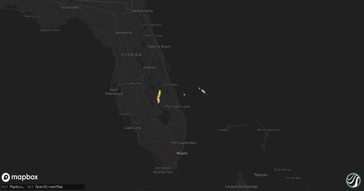
Hail Map on October 14, 2022
Get this storm
October 14 map
$229
one time, instant access
Download today. No call, no setup
Keep the $229
Bought the map and want the full workflow? Apply the entire $229 to a subscription within 7 days. None of it is wasted.
Every map, not just this one
This buys you this map. Subscription and you get every map we run, in the markets you choose from a few cities to whole states to nationwide. Plus real-time alerts the moment a storm fires.
Contact data
Name, contact info, occupancy, even credit band for addresses in the footprint. You go from where it hit to who to call.
Become the source they trust
Unlimited branding weather history reports on demand. You already have the documented answer ready for the property owner, and you are the one who showed up with it.
Property data and RoofTrace estimates
Pull up any address you have got, its value and the exact code rules for that jurisdiction, straight from One Click Code. Then RoofTrace estimates the squares, pitch, and roof value, priced the way you price.
States Impacted by Hail Map on October 14, 2022
Storm reports
New Hampshire
| Date | Description |
|---|---|
| 10/14/202210:00 AM CDT | Tree reported down across coleman drive. Several large branches downed as well. |
| 10/14/20229:55 AM CDT | Trees down on portsmouth ave. |
| 10/14/20229:55 AM CDT | Trees down across newington rd. |
| 10/14/20229:50 AM CDT | Trees down in liberty common. |
| 10/14/20229:45 AM CDT | Trees down on road. |
| 10/14/20229:45 AM CDT | A local report indicates 60 MPH wind near 1 SE RYE |
| 10/14/20229:42 AM CDT | Delayed report... Wires down... Road closed. Time estimated by radar. |
| 10/14/20229:26 AM CDT | Trees down on wires on woodland rd. Time estimated by radar. |
| 10/14/20226:00 AM CDT | At 1100 AM EDT, severe thunderstorms were located along a line extending from near Rochester to near York, moving north at 35 mph. HAZARD...60 mph wind gusts. SOURCE...Radar indicated. IMPACT...Expect damage to roofs, siding, and trees. Locations impacted include... Portland, Rochester, South Portland, Biddeford, Westbrook, Alfred, Sanford, Dover, Saco, Gorham, Somersworth, Kennebunk, Cape Elizabeth, Buxton, Berwick, Lebanon, Hollis, Kennebunkport, South Berwick and Scarborough.This includes the following highways... Interstate 295 between mile markers 1 and 6. Interstate 95 between mile markers 5 and 49. |
Maine
| Date | Description |
|---|---|
| 10/14/202211:05 AM CDT | Trees and wires down... Route 112 near river ridge drive closed. Time estimated by radar. |
| 10/14/202210:10 AM CDT | Trees down on wires. Delayed report. Time estimated from radar. |
| 10/14/202210:00 AM CDT | Large tree down across the road. |
Florida
| Date | Description |
|---|---|
| 10/14/20222:48 AM CDT | At 748 PM EDT, a severe thunderstorm was located 8 miles north of Kissimmee Prarie Preserve, or 11 miles south of Lake Marian, moving north at 10 mph. HAZARD...60 mph wind gusts and quarter size hail. SOURCE...Radar indicated. IMPACT...Hail damage to vehicles is expected. Expect wind damage to roofs, siding, and trees. This severe thunderstorm will remain over mainly rural areas of southeastern Osceola County. |
| 10/14/20222:12 AM CDT | At 712 PM EDT, a severe thunderstorm was located over Kissimmee Prarie Preserve, or 13 miles north of Basinger, moving north at 10 mph. HAZARD...Ping pong ball size hail and 60 mph wind gusts. SOURCE...Radar indicated. IMPACT...People and animals outdoors will be injured. Expect hail damage to roofs, siding, windows, and vehicles. Expect wind damage to roofs, siding, and trees. Locations impacted include... Kissimmee Prarie Preserve. |
| 10/14/20221:34 AM CDT | At 634 PM EDT, a severe thunderstorm was located near Kissimmee Prarie Preserve, or 8 miles north of Basinger, moving north at 15 mph. HAZARD...60 mph wind gusts and quarter size hail. SOURCE...Radar indicated. IMPACT...Hail damage to vehicles is expected. Expect wind damage to roofs, siding, and trees. Locations impacted include... Kissimmee Prarie Preserve. |