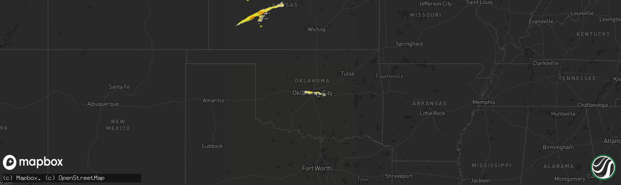
Hail Map on October 14, 2013
The weather event on October 14, 2013 includes Hail map. 4 states and 77 cities were impacted and suffered possible damage. The total estimated number of properties impacted is 47,916.
Want more than just the map?
Turn this storm into a full workflow.
- Owner + property data so you know who to knock
- OnDemand branded weather history reports to win the "did we even have hail?" argument
- RoofTrace estimate so reps stop guessing numbers at the door
Bought this map? Upgrade within 7 days and we'll credit the $230. (10-15 min setup call)
Hail
47,916
Estimated number of impacted properties by a 1.00" hail or larger0
Estimated number of impacted properties by a 1.75" hail or larger0
Estimated number of impacted properties by a 2.50" hail or largerStorm reports
Oklahoma
| Date | Description |
|---|---|
| 10/14/20131:03 AM CDT | Measured at intersection of anderson and reno. |
| 10/14/20131:03 AM CDT | Spotter reports quarter sized hail at intersection of anderson and 10th. |
Nebraska
| Date | Description |
|---|---|
| 10/14/20133:25 PM CDT | Trained spotter estimated wind gust above 50 mph at same time as hail. |
| 10/14/20132:30 PM CDT | A local report indicates 1.25 inch wind near 7 NW WAUNETA |
| 10/14/20132:12 PM CDT | Law enforcement reported zero visibility and estimated 65 mph wind gusts at imperial. |
| 10/14/20132:10 PM CDT | Cooperative observer at imperial reported extensive tree damage minor street flooding overturned pivot and hay bales being blown across highway as well as power outage |
| 10/14/20132:07 PM CDT | A local report indicates 1.50 inch wind near 3 SSW IMPERIAL |
| 10/14/20132:03 PM CDT | A local report indicates 1.00 inch wind near 7 S LAMAR |
Kansas
| Date | Description |
|---|---|
| 10/14/20135:28 PM CDT | This report came from spotternetwork.org. |
| 10/14/20135:00 PM CDT | The caller also reported pea-sized hail piling up on his deck. Strong winds were also observed. |
| 10/14/20134:35 PM CDT | A local report indicates 70 MPH wind near 8 N JETMORE |
| 10/14/20134:06 PM CDT | A local report indicates 1.00 inch wind near 9 NNW HANSTON |
| 10/14/20133:30 PM CDT | Hail covered the ground for a half hour after the hail stopped |
| 10/14/20133:15 PM CDT | A local report indicates 1.50 inch wind near 6 ENE KALVESTA |
| 10/14/20133:14 PM CDT | A local report indicates 1.75 inch wind near 2 W NICODEMUS |
| 10/14/20132:34 PM CDT | A local report indicates 1.00 inch wind near 7 NNE CHARLESTON |
| 10/14/20132:30 PM CDT | A local report indicates 1.00 inch wind near 3 W KALVESTA |
Cities Impacted by Hail Map on October 14, 2013
- North Platte, NE
- Hanston, KS
- Jetmore, KS
- Wallace, NE
- Dickens, NE
- Collyer, KS
- Hill City, KS
- Wakeeney, KS
- Ness City, KS
- Burdett, KS
- Nekoma, KS
- Alexander, KS
- Rush Center, KS
- Stockton, KS
- Bogue, KS
- Damar, KS
- Cimarron, KS
- Grinnell, KS
- Agra, KS
- Phillipsburg, KS
- Champion, NE
- Imperial, NE
- Enders, NE
- Ogallah, KS
- Park, KS
- Gove, KS
- Quinter, KS
- Woodston, KS
- Oklahoma City, OK
- Choctaw, OK
- Newalla, OK
- Mcloud, OK
- Harrah, OK
- Shawnee, OK
- Ransom, KS
- Ellis, KS
- Utica, KS
- Wauneta, NE
- Axtell, NE
- Minden, NE
- Yukon, OK
- Bethany, OK
- Kensington, KS
- Glade, KS
- Lenora, KS
- Logan, KS
- Rozel, KS
- Pierceville, KS
- Ingalls, KS
- Garden City, KS
- Morland, KS
- Hayes Center, NE
- Hoxie, KS
- Otis, KS
- Great Bend, KS
- Hoisington, KS
- Olmitz, KS
- Albert, KS
- Kinsley, KS
- Kirwin, KS
- Natoma, KS
- Palco, KS
- Penokee, KS
- Plainville, KS
- Elsie, NE
- Alton, KS
- Spearville, KS
- Grainfield, KS
- El Reno, OK
- Hays, KS
- Prairie View, KS
- Selden, KS
- York, NE
- Hershey, NE
- Yuma, CO
- Haigler, NE
- Dighton, KS