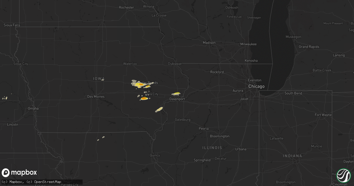
Hail Map on October 11, 2023
Get this storm
October 11 map
$229
one time, instant access
Download today. No call, no setup
Keep the $229
Bought the map and want the full workflow? Apply the entire $229 to a subscription within 7 days. None of it is wasted.
Every map, not just this one
This buys you this map. Subscription and you get every map we run, in the markets you choose from a few cities to whole states to nationwide. Plus real-time alerts the moment a storm fires.
Contact data
Name, contact info, occupancy, even credit band for addresses in the footprint. You go from where it hit to who to call.
Become the source they trust
Unlimited branding weather history reports on demand. You already have the documented answer ready for the property owner, and you are the one who showed up with it.
Property data and RoofTrace estimates
Pull up any address you have got, its value and the exact code rules for that jurisdiction, straight from One Click Code. Then RoofTrace estimates the squares, pitch, and roof value, priced the way you price.
Storm reports
Florida
| Date | Description |
|---|---|
| 10/11/20234:40 AM CDT | Corrects previous tstm wnd dmg report from 5 nw johnson. Powerlines down along sr 21 near ochwilla elementary. Time estimated by radar. |
| 10/11/20233:55 AM CDT | The short-lived ef-2 tornado initially touched down near the intersection of belle terre pkwy and pine lakes pkwy. The tornado traveled northeast through the b section |
| 10/11/20233:55 AM CDT | Florida power and light reported utility pole damage due to strong winds along the 100 block of barrington drive. |
| 10/11/20233:50 AM CDT | Ema reported powerlines down and a vehicle that was rolled over. Possible tornado. |
| 10/11/20233:50 AM CDT | Multiple trees down around west part of palm coast. Ema reported trees down near 160 bayside drive. |
| 10/11/20233:45 AM CDT | A tree was blown down along county road 75. The time of damage was based on radar. |
| 10/11/20232:00 AM CDT | Tree down blocking the roadway along sr 21 in sw putnam. Time estimated by radar. |
| 10/11/20231:17 AM CDT | Delayed report: home camera captured tornado touchdown. Lawn furniture thrown about... But no significant structural damage. |
| 10/11/20231:15 AM CDT | Emergency management reports debris blocking the roadway on hwy 44 in citrus county. Time estimated from radar. |
| 10/11/20231:12 AM CDT | Emergency management reported a tornado at us-19 and w ford island tr. Roof damage and powerlines have been reported down in the vicinity. Time estimated from radar. |
| 10/10/20239:59 PM CDT | Delayed report: loss of roof covering material |
Washington
| Date | Description |
|---|---|
| 10/11/20234:40 PM CDT | Brief tornado confirmed by video from trained spotter. Time determined by radar. Path length unknown... Appeared to be on the ground for less than 1 minute. Trash cans |
Utah
| Date | Description |
|---|---|
| 10/10/20239:27 PM CDT | Mesonet station mcku1 mccook ridge... Mack 35nw. |
Iowa
| Date | Description |
|---|---|
| 10/11/20235:42 PM CDT | Updates previous hail report from 2 ne norway. |
| 10/11/20235:16 PM CDT | A local report indicates 1.00 inch wind near Norway |
| 10/11/20234:12 PM CDT | A local report indicates 1.50 inch wind near 2 SSW Williamstown |
| 10/11/20234:05 PM CDT | Ping pong ball size hail fell for 10 minutes. |
Cities Impacted by Hail Map on October 11, 2023
- Wellman, IA
- Parnell, IA
- Kalona, IA
- Fairfax, IA
- Swisher, IA
- Cedar Rapids, IA
- Ely, IA
- Blairstown, IA
- Van Horne, IA
- Watkins, IA
- Norway, IA
- Atkins, IA
- North English, IA
- Riverside, IA
- Keota, IA
- Donahue, IA
- Eldridge, IA
- Long Grove, IA
- Nokomis, FL
- Sarasota, FL
- Ainsworth, NE
- Johnstown, NE
- Bartlett, NE
- Ewing, NE
- Bassett, NE
- Amelia, NE
- Atkinson, NE
- Davenport, IA
- Dixon, IA
- Walcott, IA
- Solon, IA
- Chambers, NE
- Elgin, NE
- Newport, NE
- Luzerne, IA
- Amana, IA
- Keystone, IA
- Newhall, IA
- Marengo, IA
- Walford, IA
- Belle Plaine, IA
- Clearwater, NE
- Princeton, IA
- Long Pine, NE
- Lucerne, MO
- Wheatland, IA
- Lowden, IA
- Bennett, IA
- Stuart, NE
- Princeton, MO
- New Liberty, IA
- Calamus, IA
- Palo, IA
- Silver Creek, NE
- Osceola, NE
- Genoa, NE
- Platte Center, NE
- Humphrey, NE
- Clearwater Beach, FL
- Dunedin, FL
- Palm Harbor, FL
- Tarpon Springs, FL
- New Port Richey, FL
- Odessa, FL
- Land O'Lakes, FL
- Crystal River, FL
- Dunnellon, FL
- Gordon, NE
- Rushville, NE
- Spalding, NE
- Valentine, NE
- Lexington, NE
- Overton, NE
- Merriman, NE
- Stromsburg, NE
- Columbus, NE
- Monroe, NE
- Hay Springs, NE
- Fullerton, NE
- Belgrade, NE
- Petersburg, NE
- Burwell, NE
- Meadow Grove, NE
- Tilden, NE
- Madison, NE
- Morning Sun, IA
- Grandview, IA
- Columbus Junction, IA
- Winfield, IA
- Wapello, IA
- Muscatine, IA
- Letts, IA
- Neligh, NE
- Albion, NE
- Wolbach, NE
- Williamsburg, IA
- Iowa City, IA
- Lindsay, NE
- Martin, SD
- Dodge, NE
- Rogers, NE
- Victor, IA
- Loup City, NE
- Mission, SD
- Mason City, NE
- Ladora, IA
- Blue Grass, IA
- Mount Vernon, IA
- Sumner, NE
- Pierce, NE
- Norfolk, NE
- Newman Grove, NE
- Battle Creek, NE
- North Liberty, IA
- Springview, NE
- Tiffin, IA
- Oxford, IA
- Lynn Center, IL
- Crescent City, FL
- Bunnell, FL
- Palm Coast, FL
- Williston, FL
- Micanopy, FL
- Colo, IA
- Nevada, IA
- Wahoo, NE
- Ithaca, NE
- Hoskins, NE
- Winside, NE
- Schuyler, NE
- Cedar Rapids, NE
- Howells, NE
- Tryon, NE
- Arthur, NE
- Mullen, NE