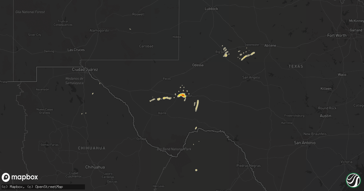
Hail Map on October 10, 2022
Get this storm
October 10 map
$229
one time, instant access
Download today. No call, no setup
Keep the $229
Bought the map and want the full workflow? Apply the entire $229 to a subscription within 7 days. None of it is wasted.
Every map, not just this one
This buys you this map. Subscription and you get every map we run, in the markets you choose from a few cities to whole states to nationwide. Plus real-time alerts the moment a storm fires.
Contact data
Name, contact info, occupancy, even credit band for addresses in the footprint. You go from where it hit to who to call.
Become the source they trust
Unlimited branding weather history reports on demand. You already have the documented answer ready for the property owner, and you are the one who showed up with it.
Property data and RoofTrace estimates
Pull up any address you have got, its value and the exact code rules for that jurisdiction, straight from One Click Code. Then RoofTrace estimates the squares, pitch, and roof value, priced the way you price.
Storm reports
Texas
| Date | Description |
|---|---|
| 10/10/20226:11 PM CDT | At 6:18 it was still hailing in fort stockton. |
| 10/10/20226:09 PM CDT | Hail is along hwy 285 north of fort stockton. |
| 10/10/20226:07 PM CDT | A local report indicates 1.00 inch wind near 1.5 N FORT STOCKTON |
| 10/10/20221:37 AM CDT | At 637 PM CDT, a severe thunderstorm was located over Fort Stockton, moving east at 10 mph. HAZARD...60 mph wind gusts and quarter size hail. SOURCE...Radar indicated. IMPACT...Hail damage to vehicles is expected. Expect wind damage to roofs, siding, and trees. Locations impacted include... Fort Stockton and Fort Stockton-Pecos County Airport. This includes Interstate 10 between mile markers 258 and 276. |
| 10/10/202212:41 AM CDT | At 541 PM CDT, a severe thunderstorm was located 9 miles west of Fort Stockton, moving northeast at 20 mph. HAZARD...60 mph wind gusts and quarter size hail. SOURCE...Radar indicated. IMPACT...Hail damage to vehicles is expected. Expect wind damage to roofs, siding, and trees. Locations impacted include... Fort Stockton, Firestone Test Track, Fort Stockton-Pecos County Airport and Imperial Reservoir.This includes Interstate 10 between mile markers 243 and 276. |
| 10/10/202212:15 AM CDT | At 515 PM CDT, a severe thunderstorm was located 13 miles southeast of Balmorhea Lake, or 24 miles northeast of Fort Davis, moving east at 30 mph. HAZARD...60 mph wind gusts and quarter size hail. SOURCE...Radar indicated. IMPACT...Hail damage to vehicles is expected. Expect wind damage to roofs, siding, and trees. Locations impacted include... Firestone Test Track.This includes Interstate 10 between mile markers 222 and 248. |