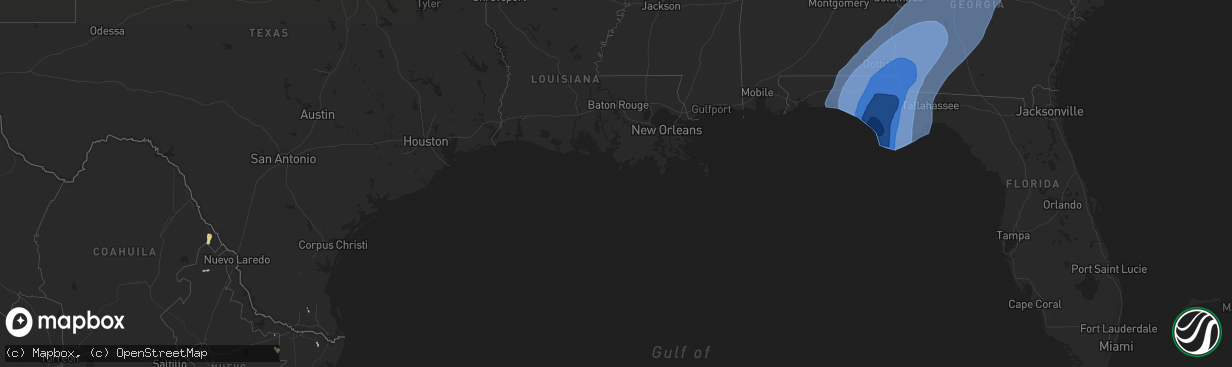
Hail Map on October 10, 2018
The weather event on October 10, 2018 includes Hail and Wind maps. 4 states and 270 cities were impacted and suffered possible damage. The total estimated number of properties impacted is 0.
Want more than just the map?
Turn this storm into a full workflow.
- Owner + property data so you know who to knock
- OnDemand branded weather history reports to win the "did we even have hail?" argument
- RoofTrace estimate so reps stop guessing numbers at the door
Bought this map? Upgrade within 7 days and we'll credit the $230. (10-15 min setup call)
Hail
Wind
0
Estimated number of impacted properties by a 1.00" hail or larger0
Estimated number of impacted properties by a 1.75" hail or larger0
Estimated number of impacted properties by a 2.50" hail or largerStorm reports
Georgia
| Date | Description |
|---|---|
| 10/10/20183:05 PM CDT | Multiple structures damaged along with trees and power lines down on flint river estates rd on hwy 128 west of roberta. |
| 10/09/201811:44 PM CDT | At 444 PM EDT, severe thunderstorms were located along a line extending from 6 miles east of Ponte Vedra Beach to Craig Field to Arlington, moving north at 40 mph. HAZARD...60 mph wind gusts. SOURCE...Radar indicated. IMPACT...Expect damage to roofs, siding, and trees. Locations impacted include... Jacksonville, St. Marys, Kingsland, Fernandina Beach, Unf, Kings Bay Base, Arlington, Yulee, Neptune Beach and Baymeadows. |
South Carolina
| Date | Description |
|---|---|
| 10/10/20183:22 AM CDT | The tornado touched down near joe collins road... Uprooting several trees along the road. It continued northward to reynolds road causing a large hardwood tree to uproo |
| 10/09/201810:48 PM CDT | A third tornado touchdown occurred near the city of orangeburg... Sc on brookside drive and pinehill road. This tornado caused non-continuous damage to large trees as i |
| 10/09/201810:28 PM CDT | A second tornado touchdown occurred along the path of the storm beginning on hollyhock rd. This tornado produced non-continuous damage to trees as it moved northward th |
| 10/09/201810:17 PM CDT | Tornado touched down near edward st and traveled about 1 mile northward to calhoun st causing minor damage to trees. |
Florida
| Date | Description |
|---|---|
| 10/10/20185:30 PM CDT | Public video shows a waterspout move ashore near lido beach as a brief tornado before dissipating. Time estimated by radar. |
| 10/10/20182:20 PM CDT | Bradford county sheriffs office reported an unconfirmend tornado touchdown near camp blanding that moved northbound at approximately 30 mph towards starke. The tornado |
| 10/10/20182:05 PM CDT | A tornado was confirmed on the ground by a jax nws employee in lake brooklyn. |
| 10/10/20182:05 PM CDT | A tornado was confirmed on the ground by clay county emergengy management. |
| 10/10/20181:39 PM CDT | A tornado was confirmed on the ground by a jax nws employee in lake brooklyn. |
| 10/09/201811:05 PM CDT | At 404 PM EDT, severe thunderstorms were located along a line extending from Picolata to near Saint Augustine to near Marineland, moving north at 40 mph. HAZARD...60 mph wind gusts. SOURCE...Radar indicated. IMPACT...Expect damage to roofs, siding, and trees. Locations impacted include... Saint Augustine, Unf, Ponte Vedra Beach, Neptune Beach, World Golf Village, Saint Augustine Beach, Baymeadows, Nocatee, Vilano Beach and San Pablo. |
Cities Impacted by Hail Map on October 10, 2018
- Raymondville, TX
- Hargill, TX
- Newton, GA
- Morgan, GA
- Midville, GA
- Dothan, AL
- Americus, GA
- Dawson, GA
- Funston, GA
- Camak, GA
- Clio, AL
- Attapulgus, GA
- Newville, AL
- Danville, GA
- Greensboro, FL
- Ideal, GA
- Cuthbert, GA
- Parrott, GA
- Pansey, AL
- Headland, AL
- Kinston, AL
- Davisboro, GA
- Shorterville, AL
- Grand Ridge, FL
- Slocomb, AL
- Vernon, FL
- Grovetown, GA
- Musella, GA
- Havana, FL
- Ebro, FL
- Fort Rucker, AL
- Norman Park, GA
- Montrose, GA
- Pitts, GA
- Adrian, GA
- Columbia, AL
- Dry Branch, GA
- Dexter, GA
- Bonaire, GA
- Tallahassee, FL
- Gibson, GA
- Box Springs, GA
- Gordon, AL
- Enterprise, AL
- Warner Robins, GA
- Climax, GA
- Byromville, GA
- Augusta, GA
- Dublin, GA
- Wrightsville, GA
- Clarksville, FL
- Laurel Hill, FL
- Panama City Beach, FL
- Cottondale, FL
- Eastman, GA
- Arabi, GA
- Marianna, FL
- Daleville, AL
- Crestview, FL
- Unadilla, GA
- Wadley, GA
- Webb, AL
- Hartsfield, GA
- Cochran, GA
- Wewahitchka, FL
- Greenwood, FL
- Blakely, GA
- Milan, GA
- Defuniak Springs, FL
- Lynn Haven, FL
- Coleman, GA
- Marshallville, GA
- Cobb, GA
- Bascom, FL
- Thomson, GA
- Cowarts, AL
- Preston, GA
- Rockledge, GA
- Plains, GA
- Irwinton, GA
- Gray, GA
- Camilla, GA
- Rochelle, GA
- Warthen, GA
- Montezuma, GA
- Midway, AL
- Swainsboro, GA
- Byron, GA
- Abbeville, AL
- Cusseta, GA
- Eatonton, GA
- Avera, GA
- Midland City, AL
- Richland, GA
- Skipperville, AL
- Moultrie, GA
- Evans, GA
- Sycamore, GA
- Panacea, FL
- Centerville, GA
- Chattahoochee, FL
- Alford, FL
- Black, AL
- Warrenton, GA
- Ochlocknee, GA
- Sparta, GA
- Destin, FL
- Carrabelle, FL
- Eastpoint, FL
- Ty Ty, GA
- East Dublin, GA
- Rupert, GA
- Freeport, FL
- Pelham, GA
- Milledgeville, GA
- Buena Vista, GA
- Kite, GA
- Knoxville, GA
- Valparaiso, FL
- Matthews, GA
- Kathleen, GA
- Macon, GA
- Samson, AL
- Fitzgerald, GA
- Fort Benning, GA
- Jakin, GA
- Coffee Springs, AL
- Elko, GA
- Coolidge, GA
- Andersonville, GA
- Lenox, GA
- Youngstown, FL
- Warwick, GA
- Ocilla, GA
- Abbeville, GA
- Cairo, GA
- Reynolds, GA
- Bartow, GA
- Clayton, AL
- Inlet Beach, FL
- De Soto, GA
- Louisville, AL
- Hartford, AL
- Cadwell, GA
- Pinehurst, GA
- Sale City, GA
- Omega, GA
- Caryville, FL
- Altha, FL
- Iron City, GA
- Weston, GA
- Poulan, GA
- Fountain, FL
- Shalimar, FL
- Miramar Beach, FL
- Mauk, GA
- Bronwood, GA
- Jeffersonville, GA
- Rebecca, GA
- Wray, GA
- Apalachicola, FL
- Chipley, FL
- Soperton, GA
- Fort Valley, GA
- Lanark Village, FL
- Leary, GA
- Meigs, GA
- Crawfordville, FL
- Arlington, GA
- Sopchoppy, FL
- Bainbridge, GA
- Blountstown, FL
- Ashburn, GA
- Bonifay, FL
- Alamo, GA
- Sylvester, GA
- Sandersville, GA
- Bristol, FL
- Louisville, GA
- Jewell, GA
- Santa Rosa Beach, FL
- Edison, GA
- Hawkinsville, GA
- Dearing, GA
- Elba, AL
- Tifton, GA
- Whigham, GA
- Brinson, GA
- Newton, AL
- Quincy, FL
- Ozark, AL
- Ashford, AL
- Perry, GA
- Morris, GA
- Campbellton, FL
- Junction City, GA
- Westville, FL
- Ariton, AL
- Dudley, GA
- Geneva, AL
- Chula, GA
- Panama City, FL
- Omaha, GA
- New Brockton, AL
- Harrison, GA
- Tennille, GA
- Roberta, GA
- Rhine, GA
- Cottonwood, AL
- Appling, GA
- Sneads, FL
- Ellaville, GA
- Lumpkin, GA
- Niceville, FL
- Eglin Afb, FL
- Damascus, GA
- Fort Gaines, GA
- Lizella, GA
- Shellman, GA
- Blythe, GA
- Sumner, GA
- McRae Helena, GA
- Chauncey, GA
- Rentz, GA
- Wrens, GA
- Hephzibah, GA
- Baconton, GA
- Midway, FL
- Eufaula, AL
- Toomsboro, GA
- Florala, AL
- Norwood, GA
- Graceville, FL
- Port Saint Joe, FL
- Butler, GA
- Cordele, GA
- Oakfield, GA
- Gordon, GA
- Albany, GA
- Gretna, FL
- Georgetown, GA
- Oglethorpe, GA
- Clopton, AL
- Telogia, FL
- Bluffton, GA
- Mitchell, GA
- Pineview, GA
- Keysville, GA
- Haddock, GA
- McIntyre, GA
- Hosford, FL
- Ponce De Leon, FL
- Doerun, GA
- Vienna, GA
- Chancellor, AL
- Jacksonville, GA
- Malone, FL
- Chester, GA
- Smithville, GA
- Thomasville, GA
- Stapleton, GA
- Colquitt, GA
- Leesburg, GA
- Leslie, GA
- Waynesboro, GA
- Donalsonville, GA
- Enigma, GA
- Glenwood, GA
- Harlem, GA
- Fort Walton Beach, FL