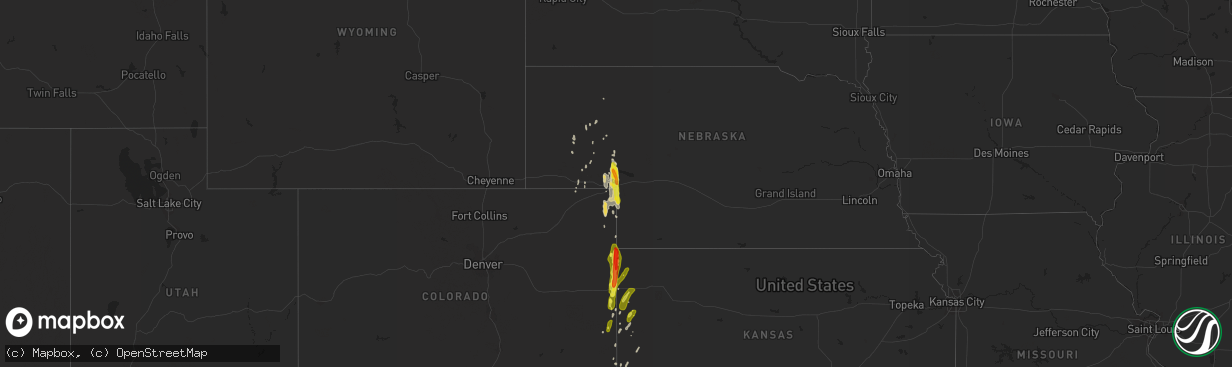
Hail Map on October 10, 2013
The weather event on October 10, 2013 includes Hail map. 5 states and 41 cities were impacted and suffered possible damage. The total estimated number of properties impacted is 4,365.
Want more than just the map?
Turn this storm into a full workflow.
- Owner + property data so you know who to knock
- OnDemand branded weather history reports to win the "did we even have hail?" argument
- RoofTrace estimate so reps stop guessing numbers at the door
Bought this map? Upgrade within 7 days and we'll credit the $230. (10-15 min setup call)
Hail
4,365
Estimated number of impacted properties by a 1.00" hail or larger607
Estimated number of impacted properties by a 1.75" hail or larger0
Estimated number of impacted properties by a 2.50" hail or largerStates Impacted by Hail Map on October 10, 2013
Storm reports
Colorado
| Date | Description |
|---|---|
| 10/10/20136:58 PM CDT | A local report indicates 1.00 inch wind near 1 SSW KANORADO |
| 10/10/20136:08 PM CDT | A local report indicates 59 MPH wind near FIRSTVIEW |
| 10/10/20136:05 PM CDT | Tree knocked down. Time estimated from radar. Relayed via twitter. |
| 10/10/20135:22 PM CDT | A local report indicates 68 MPH wind near 5 NNE LA JUNTA |
| 10/10/20134:09 PM CDT | Trinidad asos. |
| 10/09/20137:30 PM CDT | Mostly dime to nickel size but a few were quarter size. Lasted for one minute. |
| 10/09/20137:00 PM CDT | Visibility dropped to 3 miles. |
New Mexico
| Date | Description |
|---|---|
| 10/10/20136:07 PM CDT | Kcao asos. |
Nebraska
| Date | Description |
|---|---|
| 10/09/201310:15 PM CDT | Wood frame machine shed was destroyed. South door was open during the storm. |
| 10/09/20139:15 PM CDT | A local report indicates 60 MPH wind near 6 SE WALLACE |
| 10/09/20139:04 PM CDT | A local report indicates 68 MPH wind near HAYES CENTER |
| 10/09/20138:35 PM CDT | A local report indicates 1.50 inch wind near 11 NW BRULE |
| 10/09/20138:30 PM CDT | A local report indicates 1.00 inch wind near LEWELLEN |
| 10/09/20138:10 PM CDT | 3 inch live cottonwood tree branch down. Time estimated from radar. |
| 10/09/20138:10 PM CDT | A local report indicates 65 MPH wind near 10 NE CHAPPELL |
| 10/09/20138:00 PM CDT | A local report indicates 60 MPH wind near 2 S VENANGO |
| 10/09/20137:32 PM CDT | A local report indicates 65 MPH wind near LAKESIDE |
Kansas
| Date | Description |
|---|---|
| 10/09/20139:22 PM CDT | One or both of the glass doors were broken at cowboy corner either from being blown open by wind or something being blown into it/them. No idea yet as to when exactly t |
| 10/09/20139:05 PM CDT | Time estimated from radar. |
| 10/09/20138:39 PM CDT | Time estimated. |
| 10/09/20138:37 PM CDT | A local report indicates 70 MPH wind near 4 N ATWOOD |
| 10/09/20138:33 PM CDT | A local report indicates 60 MPH wind near ATWOOD |
| 10/09/20138:28 PM CDT | A local report indicates 70 MPH wind near COLBY |
| 10/09/20138:20 PM CDT | Wind damage occurred to the side of a mobile home. Powerlines were also blown down. |
| 10/09/20137:58 PM CDT | A tree limb was blown onto house across the road from this location. Powerlines were also blown down. |
| 10/09/20137:51 PM CDT | A local report indicates 58 MPH wind near 10 SSE PARKS |
| 10/09/20137:33 PM CDT | A local report indicates 63 MPH wind near 2 ENE JOHNSON CITY |
| 10/09/20137:27 PM CDT | A local report indicates 1.00 inch wind near 10 S SHARON SPRINGS |
| 10/09/20137:25 PM CDT | A local report indicates 65 MPH wind near 2 S MANTER |
| 10/09/20137:22 PM CDT | Two power poles snapped. Est 65 mph winds. Relayed via spotternetwork. |
| 10/09/20137:10 PM CDT | Sustained 60-65 mph for 2 min. Report via spotternetwork. |
Texas
| Date | Description |
|---|---|
| 10/09/20138:18 PM CDT | A local report indicates 59 MPH wind near GRUVER |
Oklahoma
| Date | Description |
|---|---|
| 10/09/20138:00 PM CDT | Oklahoma mesonet |
Cities Impacted by Hail Map on October 10, 2013
- Lewellen, NE
- Julesburg, CO
- Big Springs, NE
- Venango, NE
- Brule, NE
- Saint Francis, KS
- Burlington, CO
- Idalia, CO
- Wray, CO
- Chappell, NE
- Lodgepole, NE
- Texhoma, OK
- Goodwell, OK
- Holyoke, CO
- Holly, CO
- Sharon Springs, KS
- Tribune, KS
- Bridgeport, NE
- Sheridan Lake, CO
- Arapahoe, CO
- Manter, KS
- Kendall, KS
- Lakin, KS
- Johnson, KS
- Champion, NE
- Kanorado, KS
- Harvey, ND
- Sidney, NE
- Edson, KS
- Brewster, KS
- Syracuse, KS
- Gurley, NE
- Goodland, KS
- Angora, NE
- Leoti, KS
- Lakeside, NE
- Ovid, CO
- Amherst, CO
- Wallace, KS
- Weskan, KS
- Haigler, NE