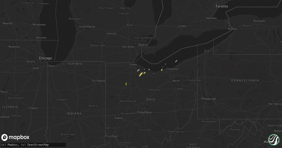
Hail Map on October 8, 2021
Get this storm
October 8 map
$229
one time, instant access
Download today. No call, no setup
Keep the $229
Bought the map and want the full workflow? Apply the entire $229 to a subscription within 7 days. None of it is wasted.
Every map, not just this one
This buys you this map. Subscription and you get every map we run, in the markets you choose from a few cities to whole states to nationwide. Plus real-time alerts the moment a storm fires.
Contact data
Name, contact info, occupancy, even credit band for addresses in the footprint. You go from where it hit to who to call.
Become the source they trust
Unlimited branding weather history reports on demand. You already have the documented answer ready for the property owner, and you are the one who showed up with it.
Property data and RoofTrace estimates
Pull up any address you have got, its value and the exact code rules for that jurisdiction, straight from One Click Code. Then RoofTrace estimates the squares, pitch, and roof value, priced the way you price.
States Impacted by Hail Map on October 8, 2021
Storm reports
Georgia
| Date | Description |
|---|---|
| 10/08/20215:44 AM CDT | At 1044 AM EDT, severe thunderstorms were located along a line extending from near Gardi to near Everett to 6 miles northwest of Waverly, moving east at 25 mph. HAZARD...60 mph wind gusts and quarter size hail. SOURCE...Radar indicated. IMPACT...Hail damage to vehicles is expected. Expect wind damage to roofs, siding, and trees. Locations impacted include... Brunswick, St. Simons Island, Dock Junction, Country Club Estates, Thalmann, Sea Island, Everett, Waynesville, Jekyll Island and Atkinson. |
| 10/08/20213:46 AM CDT | At 846 AM EDT, a severe thunderstorm was located near Surrency, moving east at 20 mph. HAZARD...60 mph wind gusts and penny size hail. SOURCE...Radar indicated. IMPACT...Expect damage to roofs, siding, and trees. Locations impacted include... Baxley, Surrency and Odum. |
| 10/08/20212:53 AM CDT | At 753 AM EDT, severe thunderstorms were located along a line extending from 10 miles northeast of West Green to 6 miles northeast of Alapaha, moving east at 30 mph. HAZARD...60 mph wind gusts and quarter size hail. SOURCE...Radar indicated. IMPACT...Hail damage to vehicles is expected. Expect wind damage to roofs, siding, and trees. Locations impacted include... Douglas, Baxley, Alma, Willacoochee, Nicholls and West Green. |
| 10/08/20212:15 AM CDT | At 715 AM EDT, a severe thunderstorm was located near Pridgen, or near Broxton, moving east at 15 mph. HAZARD...60 mph wind gusts and penny size hail. SOURCE...Radar indicated. IMPACT...Expect damage to roofs, siding, and trees. Locations impacted include... Broxton, Ambrose, Pridgen, West Green, Snipesville and Denton. |
| 10/08/20211:46 AM CDT | At 645 AM EDT, a severe thunderstorm was located near Ambrose, moving northeast at 15 mph. HAZARD...60 mph wind gusts and nickel size hail. SOURCE...Radar indicated. IMPACT...Expect damage to roofs, siding, and trees. Locations impacted include... Broxton, Ambrose and Pridgen. |
| 10/08/20211:41 AM CDT | At 641 AM EDT, a severe thunderstorm was located near Ambrose, moving northeast at 20 mph. HAZARD...60 mph wind gusts and penny size hail. SOURCE...Radar indicated. IMPACT...Expect damage to roofs, siding, and trees. Locations impacted include... Wray and Osierfield. |
| 10/07/20219:45 PM CDT | At 245 AM EDT, a severe thunderstorm was located over Cedar Grove, or 10 miles northwest of Alamo, moving east at 15 mph. HAZARD...60 mph wind gusts. SOURCE...Radar indicated. IMPACT...Expect damage to roofs, siding, and trees. Locations impacted include... Alamo, Lowery and Cedar Grove. |
| 10/07/20219:15 PM CDT | At 215 AM EDT, a severe thunderstorm was located near Cadwell, or 13 miles northeast of Eastman, moving east at 15 mph. HAZARD...60 mph wind gusts. SOURCE...Radar indicated. IMPACT...Expect damage to roofs, siding, and trees. Locations impacted include... Cadwell, Rentz, Lowery and Cedar Grove. |
| 10/07/20218:43 PM CDT | At 142 AM EDT, a severe thunderstorm was located over Cadwell, or 11 miles northeast of Eastman, moving east at 10 mph. HAZARD...60 mph wind gusts. SOURCE...Radar indicated. IMPACT...Expect damage to roofs, siding, and trees. Locations impacted include... Dexter, Cadwell, Rentz, Plainfield and Cedar Grove. |
| 10/07/20218:05 PM CDT | At 105 AM EDT, a severe thunderstorm was located near Yonkers, or 8 miles north of Eastman, moving east at 10 mph. HAZARD...60 mph wind gusts. SOURCE...Radar indicated. IMPACT...Expect damage to roofs, siding, and trees. Locations impacted include... Chester, Dexter, Cadwell, Rentz, Plainfield and Yonkers. |
Florida
| Date | Description |
|---|---|
| 10/08/20212:13 PM CDT | Emergency management reported down tree across the road at state road 100 and county road 205 in flagler county. The tree is across the west bound lane on state road 10 |
| 10/08/20214:59 AM CDT | At 959 PM EDT, severe thunderstorms were located along a line extending from 6 miles west of Loxahatchee NWR to 14 miles east of Holey Land Wildlife Refuge, moving east at 15 mph. HAZARD...60 mph wind gusts. SOURCE...Radar indicated. IMPACT...Expect damage to roofs, siding, and trees. Locations impacted include... Boca Raton, Boynton Beach, Delray Beach, Wellington and Ocean Ridge. |
| 10/07/20219:47 PM CDT | At 247 PM EDT, a severe thunderstorm was located near Palatka, moving east at 40 mph. HAZARD...60 mph wind gusts and penny size hail. SOURCE...Radar indicated. IMPACT...Expect damage to roofs, siding, and trees. Locations impacted include... Palatka, Crescent City, Pomona Park, East Palatka, Andalusia, Orange Mills, Hollister, San Mateo, Satsuma and Welaka. |
Ohio
| Date | Description |
|---|---|
| 10/08/20213:57 PM CDT | Pictures of hail around an inch from twitter. |
| 10/08/20211:00 PM CDT | A local report indicates 1.00 inch wind near 4 NNE CLYDE |
| 10/08/20214:54 AM CDT | At 954 PM EDT, a severe thunderstorm was located over Fremont, moving northeast at 15 mph. HAZARD...Quarter size hail. SOURCE...Radar indicated. IMPACT...Minor damage to vehicles is possible. Locations impacted include... Fremont, Ballville, Vickery and Stony Prairie. |
| 10/08/20211:13 AM CDT | At 613 PM EDT, a severe thunderstorm was located over Bluffton, moving north at 20 mph. HAZARD...Half dollar size hail. SOURCE...Radar indicated. IMPACT...People and animals outdoors will be injured. Expect damage to roofs, siding, windows, and vehicles. Locations impacted include... North Baltimore, McComb, Benton Ridge and Mount Cory. |
| 10/07/202111:47 PM CDT | At 447 PM EDT, a severe thunderstorm was located over Lorain, moving northeast at 15 mph. HAZARD...Half dollar size hail. SOURCE...Radar indicated. IMPACT...People and animals outdoors will be injured. Expect damage to roofs, siding, windows, and vehicles. Locations impacted include... Lorain, Avon Lake, Sheffield Lake and Sheffield. |
| 10/07/20219:00 PM CDT | Multiple quarter-size hail reports in the city of fremont. |
| 10/07/20219:00 PM CDT | Several reports of trees down across fremont. |
| 10/07/20218:53 PM CDT | Spotter reports quarter-size hail in ballville. |
| 10/07/20218:52 PM CDT | At 152 PM EDT, a severe thunderstorm was located near Clyde, or near Fremont, moving north at 15 mph. HAZARD...60 mph wind gusts and quarter size hail. SOURCE...Radar indicated. IMPACT...Minor damage to vehicles is possible. Expect damage to trees and power lines. Locations impacted include... Port Clinton, Clyde, Catawba Island, Bay View, Whites Landing and Vickery. |
Utah
| Date | Description |
|---|---|
| 10/07/202110:56 PM CDT | At 356 PM MDT, a severe thunderstorm was located 18 miles east of Wendover, moving northeast at 25 mph. HAZARD...60 mph wind gusts. SOURCE...Radar indicated. IMPACT...Expect damage to roofs, siding, and trees. Locations impacted include... Knolls, Utah Test and Training Range North and Bonneville Salt Flats.This includes Interstate 80 in Utah between mile markers 11 and 44. |
| 10/07/202110:36 PM CDT | At 336 PM MDT, a severe thunderstorm was located 16 miles southeast of Wendover, moving northeast at 25 mph. HAZARD...60 mph wind gusts. SOURCE...Radar indicated. IMPACT...Expect damage to roofs, siding, and trees. Locations impacted include... Utah Test and Training Range South and Bonneville Salt Flats. This includes Interstate 80 in Utah between mile markers 9 and 28. |
Minnesota
| Date | Description |
|---|---|
| 10/08/20213:45 AM CDT | At 844 PM CDT, a severe thunderstorm was located over northwestern White Earth Nation, or 39 miles north of Detroit Lakes, moving east at 25 mph. HAZARD...60 mph wind gusts and half dollar size hail. SOURCE...Radar indicated. IMPACT...Hail damage to vehicles is expected. Expect wind damage to roofs, siding, and trees. Locations impacted include... Beaulieu, Island Lake in Mahnomen County, Mahkonce and Lengby. |
| 10/08/20211:30 AM CDT | At 629 PM CDT, a severe thunderstorm was located over Argusville, or 15 miles northwest of Fargo, moving northeast at 15 mph. HAZARD...60 mph wind gusts and quarter size hail. SOURCE...Radar indicated. IMPACT...Hail damage to vehicles is expected. Expect wind damage to roofs, siding, and trees. This severe thunderstorm will be near... Gardner around 640 PM CDT.Other locations in the path of this severe thunderstorm includeGeorgetown and Perley.This includes Interstate 29 between mile markers 76 and 88. |
| 10/08/20211:21 AM CDT | At 621 PM CDT, a severe thunderstorm was located over Casperson, or 20 miles south of Roseau, moving east at 15 mph. HAZARD...60 mph wind gusts and quarter size hail. SOURCE...Radar indicated. IMPACT...Hail damage to vehicles is expected. Expect wind damage to roofs, siding, and trees. This severe thunderstorm will be near... Skime around 635 PM CDT.Other locations in the path of this severe thunderstorm include HayesLake State Park. |
| 10/08/20211:04 AM CDT | At 603 PM CDT, a severe thunderstorm was located over Huot, or 20 miles southwest of Thief River Falls, moving northeast at 10 mph. HAZARD...60 mph wind gusts and quarter size hail. SOURCE...Radar indicated. IMPACT...Hail damage to vehicles is expected. Expect wind damage to roofs, siding, and trees. This severe thunderstorm will be near... Perault around 620 PM CDT.Other locations in the path of this severe thunderstorm includeWylie, Red Lake Falls, Terrebonne and St. Hilaire. |
| 10/08/202112:26 AM CDT | At 526 PM CDT, a severe thunderstorm was located near Caledonia, or 31 miles south of Grand Forks, moving northeast at 10 mph. HAZARD...60 mph wind gusts and quarter size hail. SOURCE...Radar indicated. IMPACT...Hail damage to vehicles is expected. Expect wind damage to roofs, siding, and trees. This severe thunderstorm will be near... Caledonia around 545 PM CDT.Other locations in the path of this severe thunderstorm includeShelly, Nielsville, Climax and Eldred.This includes Interstate 29 between mile markers 108 and 109. |
| 10/08/202112:16 AM CDT | At 516 PM CDT, a severe thunderstorm was located over Crookston, or 20 miles east of Grand Forks, moving northeast at 15 mph. HAZARD...60 mph wind gusts and quarter size hail. SOURCE...Radar indicated. IMPACT...Hail damage to vehicles is expected. Expect wind damage to roofs, siding, and trees. Locations impacted include... Gentilly, Huot, Dorothy, Wylie, Red Lake Falls and Perault. |
Cities Impacted by Hail Map on October 8, 2021
- Deland, FL
- Fremont, OH
- Gibsonburg, OH
- Woodville, OH
- Elmore, OH
- Lorain, OH
- Port Clinton, OH
- Bejou, MN
- Argusville, ND
- Daytona Beach, FL
- Port Orange, FL
- Burgoon, OH
- Mahnomen, MN
- Gary, MN
- Vickery, OH
- Clyde, OH
- Tiffin, OH
- Bettsville, OH
- Kansas, OH
- Milan, OH
- Orange City, FL
- Willacoochee, GA
- Lake Helen, FL
- Findlay, OH
- Rawson, OH
- Bluffton, OH
- Mount Cory, OH