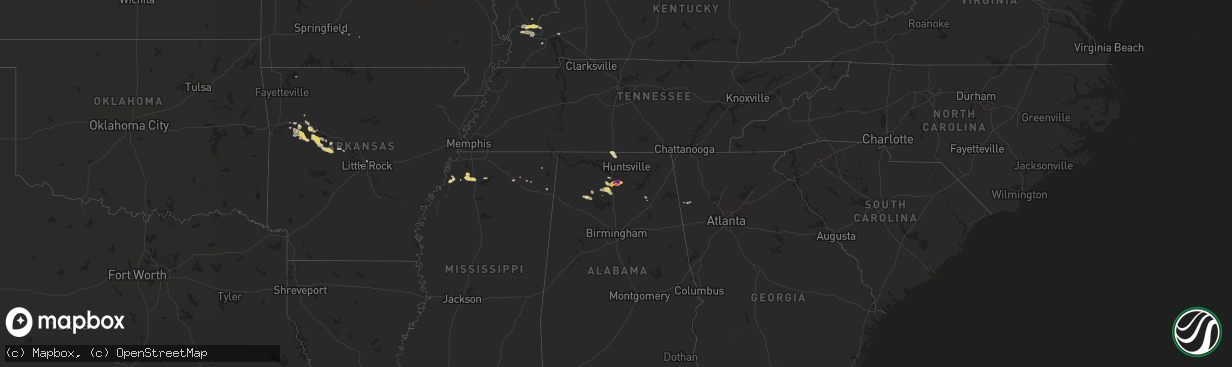
Hail Map on October 8, 2014
The weather event on October 8, 2014 includes Hail map. 10 states and 207 cities were impacted and suffered possible damage. The total estimated number of properties impacted is 1,239.
Want more than just the map?
Turn this storm into a full workflow.
- Owner + property data so you know who to knock
- OnDemand branded weather history reports to win the "did we even have hail?" argument
- RoofTrace estimate so reps stop guessing numbers at the door
Bought this map? Upgrade within 7 days and we'll credit the $230. (10-15 min setup call)
Hail
1,239
Estimated number of impacted properties by a 1.00" hail or larger741
Estimated number of impacted properties by a 1.75" hail or larger820
Estimated number of impacted properties by a 2.50" hail or largerStates Impacted by Hail Map on October 8, 2014
Storm reports
Alabama
| Date | Description |
|---|---|
| 10/08/20144:34 PM CDT | Baseball hail reported by sheriffs office...from cutoff road at hwy 36 to hwy 36 and hwy 67 intersection. |
| 10/07/20147:30 PM CDT | Quarter size hail was reported. |
New Hampshire
| Date | Description |
|---|---|
| 10/08/20148:22 AM CDT | Trees down on rt 113 |
Arkansas
| Date | Description |
|---|---|
| 10/08/20148:10 AM CDT | Trees were downed and contruction barrels were blown onto the highway on the south side of clarksville. |
Cities Impacted by Hail Map on October 8, 2014
- Ozark, AR
- Mulberry, AR
- Braymer, MO
- Lexington, MO
- Higginsville, MO
- Alma, MO
- Corder, MO
- Vinemont, AL
- Falkville, AL
- Pacific, MO
- Labadie, MO
- Villa Ridge, MO
- Gray Summit, MO
- Mendon, MO
- Sumner, MO
- Daykin, NE
- Plymouth, NE
- De Witt, NE
- Swanton, NE
- Western, NE
- Houston, AL
- Silver Creek, GA
- Cedartown, GA
- Malta Bend, MO
- Como, MS
- Cosby, MO
- Savannah, MO
- Summerfield, KS
- Oketo, KS
- Beattie, KS
- Burchard, NE
- Liberty, NE
- Seneca, KS
- Adona, AR
- Perry, AR
- Boaz, AL
- Kevil, KY
- Hartselle, AL
- Somerville, AL
- Fairbury, NE
- Alexandria, NE
- Marshall, MO
- Waverly, MO
- Miami, MO
- Valley Falls, KS
- New Blaine, AR
- Clarksville, AR
- Scranton, AR
- Hartman, AR
- Bourbon, MO
- Potosi, MO
- Effingham, KS
- Horton, KS
- Axtell, KS
- Marysville, KS
- Jansen, NE
- Platte City, MO
- Kansas City, MO
- Altus, AR
- Hughesville, MO
- Smithton, MO
- Sedalia, MO
- Otterville, MO
- Corning, KS
- Goff, KS
- Lawson, MO
- Rocheport, MO
- Kingston, MO
- Polo, MO
- Wymore, NE
- Paris, AR
- Carrollton, MO
- Albany, MO
- Prairie Home, MO
- Jamestown, MO
- Centertown, MO
- Jefferson City, MO
- Golconda, IL
- Metropolis, IL
- Brookport, IL
- Sweet Springs, MO
- Knoxville, AR
- Addison, AL
- Danville, AL
- Cullman, AL
- Ardmore, AL
- Athens, AL
- Ardmore, TN
- Elkmont, AL
- Toney, AL
- Prospect, TN
- Pilot Grove, MO
- Boonville, MO
- Nelson, MO
- Seymour, MO
- Guntown, MS
- Baldwyn, MS
- Delaware, AR
- Dardanelle, AR
- Belleville, AR
- Linn, MO
- Centralia, KS
- Bunceton, MO
- Lathrop, MO
- Senatobia, MS
- New Bloomfield, MO
- Darlington, MO
- Norborne, MO
- Haleyville, AL
- Double Springs, AL
- Robinson, KS
- Atchison, KS
- Netawaka, KS
- Vermillion, KS
- Wetmore, KS
- Ola, AR
- Casa, AR
- Smithville, MO
- Mayview, MO
- Odessa, MO
- Everest, KS
- Muscotah, KS
- Whiting, KS
- Holton, KS
- Lancaster, KS
- Crenshaw, MS
- Sarah, MS
- Sardis, MS
- Leavenworth, KS
- Stewartsville, MO
- Edgerton, MO
- Farley, MO
- Waldron, MO
- Kansas City, KS
- Camden Point, MO
- Lansing, KS
- Pawnee City, NE
- De Witt, MO
- Loose Creek, MO
- Eva, AL
- Cummings, KS
- Nortonville, KS
- Syracuse, MO
- Tipton, MO
- Florence, MO
- Pottsville, AR
- Cave Spring, GA
- West Paducah, KY
- Danville, AR
- Osborn, MO
- Rushville, MO
- De Kalb, MO
- North Little Rock, AR
- Sherwood, AR
- Beatrice, NE
- Holts Summit, MO
- Fulton, MO
- Hartsburg, MO
- Washington, MO
- Denison, KS
- Fairview, KS
- Hiawatha, KS
- Paducah, KY
- Circleville, KS
- Powhattan, KS
- Perryville, AR
- Cecil, AR
- Easton, KS
- Fulton, MS
- Dundee, MS
- Sabetha, KS
- Bern, KS
- California, MO
- Clarksburg, MO
- Baileyville, KS
- Dover, MO
- Branch, AR
- Ratcliff, AR
- Magazine, AR
- Blue Springs, NE
- Gentry, MO
- Coahoma, MS
- Westphalia, MO
- Oark, AR
- Weston, MO
- Smithland, KY
- New Albany, MS
- Decatur, AL
- Benton, KY
- Calvert City, KY
- De Soto, MO
- Boaz, KY
- Franklin, MO
- Blackwater, MO
- Houstonia, MO
- Arrow Rock, MO
- Stanberry, MO
- Grand Chain, IL
- Eddyville, KY
- Catawissa, MO
- Blackburn, MO
- Cowgill, MO
- Frankfort, KS
- Home, KS
- Bremen, KS
- Attalla, AL
- Sledge, MS