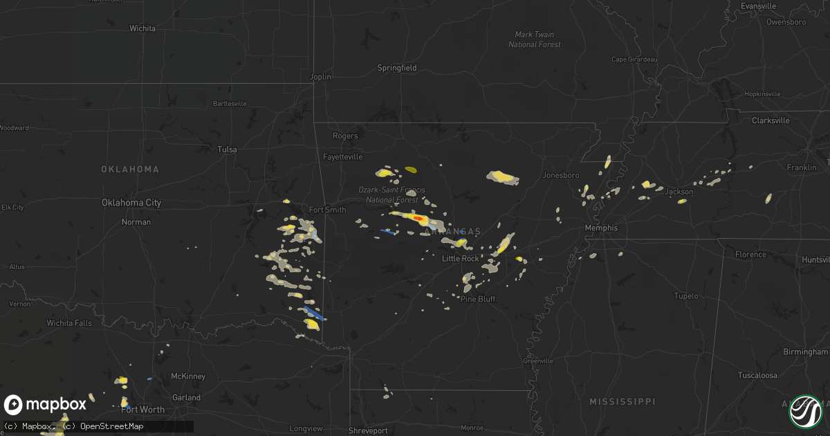
Hail Map on October 6, 2019
Get this storm
October 6 map
$229
one time, instant access
Download today. No call, no setup
Keep the $229
Bought the map and want the full workflow? Apply the entire $229 to a subscription within 7 days. None of it is wasted.
Every map, not just this one
This buys you this map. Subscription and you get every map we run, in the markets you choose from a few cities to whole states to nationwide. Plus real-time alerts the moment a storm fires.
Contact data
Name, contact info, occupancy, even credit band for addresses in the footprint. You go from where it hit to who to call.
Become the source they trust
Unlimited branding weather history reports on demand. You already have the documented answer ready for the property owner, and you are the one who showed up with it.
Property data and RoofTrace estimates
Pull up any address you have got, its value and the exact code rules for that jurisdiction, straight from One Click Code. Then RoofTrace estimates the squares, pitch, and roof value, priced the way you price.
States Impacted by Hail Map on October 6, 2019
Storm reports
Oklahoma
| Date | Description |
|---|---|
| 10/06/20196:09 PM CDT | 3 large trees blown over in mt herman community. |
| 10/06/20196:09 PM CDT | 1 inch hail reported in mt. Herman ok and some tree damage reported... Branches down. |
| 10/06/20194:00 PM CDT | Numerous trees down on east side of poteau. Time estimated via radar. |
| 10/06/20193:11 AM CDT | At 810 PM CDT, a severe thunderstorm was located 13 miles south of Idabel, or 15 miles northeast of Clarksville, moving east at 25 mph. HAZARD...60 mph wind gusts and quarter size hail. SOURCE...Radar indicated. IMPACT...Hail damage to vehicles is expected. Expect wind damage to roofs, siding, and trees. Locations impacted include... Foreman, Winthrop, Arkinda, Haworth, Bokhoma, Almont, Moon, Beaverdams, Goodlake, Harris, English, Wallace, Tom, Arden, America and Bryarly. |
| 10/06/20192:42 AM CDT | At 742 PM CDT, a severe thunderstorm was located 9 miles west of Horatio, moving east at 25 mph. HAZARD...60 mph wind gusts and nickel size hail. SOURCE...Radar indicated. IMPACT...Expect damage to roofs, siding, and trees. Locations impacted include... De Queen, Horatio, Lockesburg, Winthrop, Ben Lomond, Oak Grove, Eagletown, Silver Ridge, Cerrogordo, Geneva, Central, Goodwater, Shinewell, Provo, West Line, Bellview and West Otis. |
| 10/06/20191:44 AM CDT | At 644 PM CDT, a severe thunderstorm was located 12 miles north of Broken Bow, or 22 miles northwest of De Queen, moving east at 25 mph. HAZARD...60 mph wind gusts and quarter size hail. SOURCE...Radar indicated. IMPACT...Hail damage to vehicles is expected. Expect wind damage to roofs, siding, and trees. Locations impacted include... De Queen, Broken Bow, Gillham, Eagletown, Glover, Hochatown, West Line, Oak Hill and Golden. |
| 10/05/20197:16 PM CDT | Tree reported down on red arrow road. |
Mississippi
| Date | Description |
|---|---|
| 10/06/20196:29 AM CDT | At 1129 PM CDT, a severe thunderstorm was located near Barr, or 12 miles west of Wall Doxey State Park, moving east at 30 mph. HAZARD...60 mph wind gusts. SOURCE...Radar indicated. IMPACT...Expect damage to roofs, siding, and trees. Locations impacted include... Holly Springs, Wall Doxey State Park, Bethlehem, Laws Hill, Marianna, Potts Camp, Malone, Wakefield, Waterford, Aiken, Higdon, Wyatte, Tyro, Gilton, Chulahoma, Lake Center, New Garden, Thyatira, Galena and Spraggins. |
| 10/05/20199:40 PM CDT | Power poles down at highway 301 and oak grove road. |
Tennessee
| Date | Description |
|---|---|
| 10/06/20196:46 PM CDT | One inch sized hail in pinson. |
| 10/06/20195:59 AM CDT | At 1059 PM CDT, a severe thunderstorm was located over Morris Chapel, or 11 miles northwest of Savannah, moving east at 40 mph. HAZARD...60 mph wind gusts. SOURCE...Radar indicated. IMPACT...Expect damage to roofs, siding, and trees. Locations impacted include... Savannah, Henderson, Selmer, Parsons, Adamsville, Decaturville, Sardis, Reagan, Morris Chapel, Jacks Creek, Olive Hill, Montgomery, McNairy, Crump, Scotts Hill, Bethel Springs, Eastview, Ramer, Saltillo and Finger. |
| 10/06/201912:02 AM CDT | At 502 PM CDT, a severe thunderstorm was located near Belle Eagle, or 8 miles northwest of Brownsville, moving east at 20 mph. HAZARD...60 mph wind gusts and quarter size hail. SOURCE...Radar indicated. IMPACT...Hail damage to vehicles is expected. Expect wind damage to roofs, siding, and trees. Locations impacted include... Brownsville, Alamo, Bells, Belle Eagle, Holly Grove, Maury City, Fruitvale, Quincy, Allens, Crockett Mills, Christmasville, Rudolph, Brims Corner, Tibbs, Jones, Johnsons Grove, Oakview, Owl City and Toulon. |
Arkansas
| Date | Description |
|---|---|
| 10/06/20196:26 PM CDT | Large tree was blown down across portions of the east bound lanes of interstate 40. |
| 10/06/20196:26 PM CDT | A local report indicates 1.75 inch wind near ATKINS |
| 10/06/20196:04 PM CDT | A local report indicates 1.00 inch wind near RUSSELLVILLE |
| 10/06/20192:45 AM CDT | At 745 PM CDT, a severe thunderstorm was located over Olmstead, or near Little Rock AFB, moving southeast at 30 mph. HAZARD...60 mph wind gusts and penny size hail. SOURCE...Radar indicated. IMPACT...Expect damage to roofs, siding, and trees. Locations impacted include... North Little Rock... Sherwood... Jacksonville... Little Rock AFB... North Little Rock Airport... Gibson... Gravel Ridge... Sylvan Hills... McAlmont... South Bend... Olmstead... Marche... Camp Robinson... Macon... Cato... Furlow... Kerr... Galloway...This includes the following highways... Interstate 40 between mile markers 159 and 168. Interstate 440 between mile markers 10 and 14. US Highway 67 between mile markers 3 and 13. |
| 10/06/20192:38 AM CDT | At 738 PM CDT, a severe thunderstorm was located over Vilonia, or 11 miles east of Conway, moving east at 30 mph. HAZARD...60 mph wind gusts. SOURCE...Radar indicated. IMPACT...Expect damage to roofs, siding, and trees. Locations impacted include... Cabot... Beebe... Ward... Vilonia... Austin in Lonoke County... Old Austin... Parnell... Sylvania... Holland... Otto... Hamlet... This includes US Highway 67 between mile markers 14 and 30. |
| 10/06/20192:24 AM CDT | At 724 PM CDT, a severe thunderstorm was located near Jacksonport, or 8 miles northwest of Newport, moving east at 35 mph. HAZARD...60 mph wind gusts and quarter size hail. SOURCE...Radar indicated. IMPACT...Hail damage to vehicles is expected. Expect wind damage to roofs, siding, and trees. Locations impacted include... Newport... Tuckerman... Diaz... Newark... Swifton... Grubbs... Oil Trough... Jacksonport... Magness... Algoa... McFadden... Sulphur Rock... Campbell Station... Beedeville... Amagon... Balch... Blackville... Shoffner... Charlotte... Stegall...This includes US Highway 67 between mile markers 75 and 101. |
| 10/06/20192:01 AM CDT | At 701 PM CDT, a severe thunderstorm was located over Menifee, or 9 miles northwest of Conway, moving east at 30 mph. HAZARD...60 mph wind gusts and quarter size hail. SOURCE...Radar indicated. IMPACT...Hail damage to vehicles is expected. Expect wind damage to roofs, siding, and trees. Locations impacted include... Conway... Greenbrier... Vilonia... Wooster... Enola... Menifee... Bethlehem... Hill Creek... Pickles Gap... Springhill... Toad Suck... Springfield... Solgohachia... Plumerville... Holland... Barney... Hamlet... Saltillo... Mt Olive in Conway County... Overcup...This includes Interstate 40 between mile markers 109 and 130. |
| 10/06/20191:55 AM CDT | At 655 PM CDT, a severe thunderstorm was located over Batesville, moving east at 30 mph. HAZARD...60 mph wind gusts and quarter size hail. SOURCE...Radar indicated. IMPACT...Hail damage to vehicles is expected. Expect wind damage to roofs, siding, and trees. Locations impacted include... Batesville... Newark... Oil Trough... Magness... Moorefield... Salado... Southside in Independence Count... Sulphur Rock... Charlotte... Rosie... Gainesboro... Desha... Pfeiffer... Sandtown... Cord... |
| 10/06/20191:53 AM CDT | At 653 PM CDT, a severe thunderstorm was located over Orion, or 15 miles northeast of Sheridan, moving northeast at 15 mph. HAZARD...60 mph wind gusts and quarter size hail. SOURCE...Radar indicated. IMPACT...Hail damage to vehicles is expected. Expect wind damage to roofs, siding, and trees. Locations impacted include... Redfield... Estes... Hensley Island... Orion... Hensley... Tar Camp Park... Bredlow Corner... Woodson... Wright... Kearney... F.B. Baugh Recreation Area... This includes Interstate 530 between mile markers 13 and 23. |
| 10/06/20191:45 AM CDT | At 645 PM CDT, a severe thunderstorm was located near Danville, moving east at 20 mph. HAZARD...60 mph wind gusts and quarter size hail. SOURCE...Radar indicated. IMPACT...Hail damage to vehicles is expected. Expect wind damage to roofs, siding, and trees. Locations impacted include... Russellville... Danville... Dardanelle... Pottsville... Ola... Carden Bottoms... Mt Nebo State Park... Plainview in Yell County... Petit Jean River WMA... Galla Creek WMA... Mosley... Belleville... Casa... Corinth... Birta... Nimrod... Ranger... Holla Bend... Kingston... Spring Lake Campground... |
| 10/06/20191:36 AM CDT | At 636 PM CDT, a severe thunderstorm was located over Happy Bend, or 11 miles northwest of Morrilton, moving east at 20 mph. HAZARD...Golf ball size hail. SOURCE...Public. IMPACT...People and animals outdoors will be injured. Expect damage to roofs, siding, windows, and vehicles. Locations impacted include... Morrilton... Atkins... Oppelo... Bethlehem... Sequoya Park... Hill Creek... Happy Bend... Solgohachia... St. Vincent... Hattieville... Springfield... Petit Jean State Park... Plumerville... Birdtown... Blackwell... Overcup... Wonderview... Economy... Kenwood... Macedonia in Conway County...This includes Interstate 40 between mile markers 94 and 115. |
| 10/06/201912:59 AM CDT | At 559 PM CDT, a severe thunderstorm was located over Russellville, moving east at 20 mph. HAZARD...60 mph wind gusts and quarter size hail. SOURCE...Radar indicated. IMPACT...Hail damage to vehicles is expected. Expect wind damage to roofs, siding, and trees. Locations impacted include... Russellville... Dardanelle... Atkins... Pottsville... Happy Bend... Galla Creek WMA... Hattieville... Petit Jean State Park... Lake Dardanelle... Blackwell... Gum Log... Economy... Kenwood... Macedonia in Conway County... Oak Grove in Pope County... This includes Interstate 40 between mile markers 80 and 103. |
| 10/06/201912:44 AM CDT | At 543 PM CDT, a severe thunderstorm was located 16 miles southeast of Nashoba, or 26 miles southeast of Clayton, moving east at 25 mph. HAZARD...60 mph wind gusts and quarter size hail. SOURCE...Radar indicated. IMPACT...Hail damage to vehicles is expected. Expect wind damage to roofs, siding, and trees. Locations impacted include... Plunketville, Smithville, Watson, Bethel, Battiest, Pickens, Mount Herman and Sherwood. |
| 10/05/201911:38 PM CDT | At 438 PM CDT, a severe thunderstorm was located near Upper Buffalo Wilderness Area, or 17 miles southwest of Jasper, moving east at 35 mph. HAZARD...60 mph wind gusts and quarter size hail. SOURCE...Radar indicated. IMPACT...Hail damage to vehicles is expected. Expect wind damage to roofs, siding, and trees. Locations impacted include... Piercetown... Carver... Moore... Upper Buffalo Wilderness Area... Walnut... Ben Hur... Bass... Wayton... Mossville... Fallsville... Crossroad... Vendor... Parthenon... Swain... Gum Springs in Newton County... Mt Judea... Deer... Dixon Ridge... Cowell... Nail... |
| 10/05/201911:34 PM CDT | At 433 PM CDT, a severe thunderstorm was located near Des Arc, moving northeast at 30 mph. HAZARD...60 mph wind gusts and quarter size hail. SOURCE...Radar indicated. IMPACT...Hail damage to vehicles is expected. Expect wind damage to roofs, siding, and trees. Locations impacted include... Des Arc... Hazen... Barrettsville... Center Point... Sand Hill... Childers...This includes Interstate 40 between mile markers 190 and 199. |
| 10/05/201910:38 PM CDT | At 337 PM CDT, a severe thunderstorm was located over Parkers Corner, or 13 miles northwest of Stuttgart, moving northeast at 20 mph. HAZARD...60 mph wind gusts and quarter size hail. SOURCE...Radar indicated. IMPACT...Hail damage to vehicles is expected. Expect wind damage to roofs, siding, and trees. Locations impacted include... Hazen... De Valls Bluff... Humnoke... Parkers Corner... Stuttgart Municipal Airport... Brummitt... Slovak... Tollville... Seaton... This includes Interstate 40 between mile markers 195 and 196. |
| 10/05/201910:36 PM CDT | At 336 PM CDT, a severe thunderstorm was located over Peppers Landing, or near Clarendon, moving northeast at 10 mph. HAZARD...60 mph wind gusts and quarter size hail. SOURCE...Radar indicated. IMPACT...Hail damage to vehicles is expected. Expect wind damage to roofs, siding, and trees. Locations impacted include... Brinkley... Clarendon... Fredonia... Alfrey... Allendale... Dobbs Landing... Peppers Landing... Fargo... Brasfield... Dagmar WMA... Keevil... Zent... Monroe... This includes Interstate 40 between mile markers 205 and 218. |
| 10/05/20199:57 PM CDT | At 256 PM CDT, a severe thunderstorm was located 7 miles south of Piercetown, or 12 miles southeast of Jasper, moving east at 35 mph. HAZARD...60 mph wind gusts and quarter size hail. SOURCE...Radar indicated. IMPACT...Hail damage to vehicles is expected. Expect wind damage to roofs, siding, and trees. Locations impacted include... Marshall... Marsena... Kay... Eula... Bohannon... Imo... Witts Spring... Moore... Dabney... Point Peter... Watts... Ben Hur... Bass... Canaan... Chimes... Mt Judea... Snowball... Cowell... Tilly... Lurton... |
| 10/05/20199:33 PM CDT | At 233 PM CDT, a severe thunderstorm was located 8 miles northeast of Walnut, or 9 miles southwest of Jasper, moving east at 30 mph. HAZARD...60 mph wind gusts and quarter size hail. SOURCE...Radar indicated. IMPACT...Hail damage to vehicles is expected. Expect wind damage to roofs, siding, and trees. Locations impacted include... Moore... Piercetown... Ben Hur... Bass... Wayton... Crossroad... Vendor... Parthenon... Swain... Gum Springs in Newton County... Mt Judea... Deer... Cowell... Lurton... Nail... |
| 10/05/20197:48 PM CDT | A local report indicates 60 MPH wind near OLMSTEAD |
| 10/05/20197:48 PM CDT | A local report indicates 1.25 inch wind near OLMSTEAD |
| 10/05/20197:38 PM CDT | A local report indicates 1.00 inch wind near 2 WNW TARNCEVILLE |
Texas
| Date | Description |
|---|---|
| 10/06/20196:20 PM CDT | Mping report of snapped tree limbs and power poles |
| 10/06/20194:51 PM CDT | Nws retired met reports 60 mph wind gust at robson ranch |
| 10/06/20194:15 PM CDT | Ranger awos reported 62 mph wind gust at 415 pm |
| 10/06/201912:58 AM CDT | At 558 PM CDT, a severe thunderstorm was located near Willow Park, or near Azle, moving southeast at 15 mph. HAZARD...60 mph wind gusts and quarter size hail. SOURCE...Radar indicated. IMPACT...Hail damage to vehicles is expected. Expect wind damage to roofs, siding, and trees. Locations impacted include... Fort Worth, Haltom City, Burleson, Weatherford, Benbrook, Saginaw, White Settlement, Crowley, Forest Hill, Azle, River Oaks, Kennedale, Everman, Sansom Park, Lake Worth, Rendon, Eagle Mountain, Willow Park, Reno and Edgecliff Village.This includes the following highways... Interstate 35W between mile markers 38 and 55. Interstate 20 between mile markers 413 and 441. Interstate 30 between mile markers 1 and 20. |
| 10/05/201911:41 PM CDT | At 441 PM CDT, a severe thunderstorm was located 8 miles south of Ranger, moving southeast at 15 mph. HAZARD...60 mph wind gusts and quarter size hail. SOURCE...Emergency management. IMPACT...Hail damage to vehicles is expected. Expect wind damage to roofs, siding, and trees. Locations impacted include... Ranger, De Leon and Gorman. This includes Interstate 20 between mile markers 350 and 351. |
| 10/05/201911:29 PM CDT | At 429 PM CDT, a severe thunderstorm was located near Boyd, or 7 miles south of Decatur, moving southeast at 15 mph. HAZARD...60 mph wind gusts and quarter size hail. SOURCE...Radar indicated. IMPACT...Hail damage to vehicles is expected. Expect wind damage to roofs, siding, and trees. Locations impacted include... Fort Worth, Denton, Flower Mound, Decatur, Briar, Roanoke, Pecan Acres, Argyle, Justin, Northlake, Haslet, New Fairview, Aurora, Boyd, Corral City, Cottondale, Rhome, Ponder and Newark.This includes Interstate 35W between mile markers 61 and 83. |
Cities Impacted by Hail Map on October 6, 2019
- Tucker, AR
- Brownwood, TX
- May, TX
- Wilburton, OK
- Tuskahoma, OK
- Talihina, OK
- Cisco, TX
- Eastland, TX
- Eldorado, TX
- Snow, OK
- Nashoba, OK
- Brownsville, TN
- Paradise, TX
- Decatur, TX
- Manila, AR
- Dell, AR
- Batesville, AR
- Mineral Wells, TX
- Graford, TX
- Blytheville, AR
- Lexington, TN
- Wildersville, TN
- Darden, TN
- Parsons, TN
- Holladay, TN
- Deer, AR
- Magazine, AR
- Booneville, AR
- Paris, AR
- Carlsbad, TX
- Stigler, OK
- Keota, OK
- Broken Bow, OK
- Byhalia, MS
- Jefferson, AR
- Redfield, AR
- White Hall, AR
- Sheridan, AR
- Poteau, OK
- Cameron, OK
- Shady Point, OK
- Pelsor, AR
- Comanche, TX
- Dublin, TX
- Gustine, TX
- Jerusalem, AR
- Scotland, AR
- Biscoe, AR
- Des Arc, AR
- Tunica, MS
- Hernando, MS
- San Angelo, TX
- Ponca, AR
- Perry, AR
- Adona, AR
- Honobia, OK
- Hattieville, AR
- Smithville, OK
- Russellville, AR
- Morrilton, AR
- Pottsville, AR
- Atkins, AR
- Pettigrew, AR
- Kingston, AR
- Hazen, AR
- Carlisle, AR
- Wister, OK
- Hensley, AR
- Little Rock, AR
- England, AR
- Valliant, OK
- Malvern, AR
- Rising Star, TX
- Cross Plains, TX
- De Leon, TX
- Blackwell, TX
- Wingate, TX
- Hampshire, TN
- Summertown, TN
- Mccurtain, OK
- Ozona, TX
- Eden, TX
- Ballinger, TX
- Cherry Valley, AR
- Idabel, OK
- Haworth, OK
- Danville, AR
- Lamar, AR
- Christoval, TX
- Clarendon, AR
- Gorman, TX
- Howe, OK
- Desdemona, TX
- Ranger, TX
- Iowa, LA
- Desha, AR
- Charlotte, AR
- Sulphur Rock, AR
- Newark, AR
- Magness, AR
- Kinta, OK
- Red Oak, OK
- Cabot, AR
- Austin, AR
- Vian, OK
- Sherwood, AR
- Bronte, TX
- Whitesboro, OK
- Springhill, LA
- Taylor, AR
- Coleman, TX
- Boyd, TX
- Robert Lee, TX
- Miles, TX
- Hagarville, AR
- Beech Bluff, TN
- Huron, TN
- Lepanto, AR
- Griffithville, AR
- Searcy, AR
- Strawn, TX
- Valley View, TX
- Ada, OK
- Weatherford, TX
- Paron, AR
- Mount Judea, AR
- Gainesville, TX
- Collinsville, TX
- Burkett, TX
- Norton, TX
- Azle, TX
- Eufaula, OK
- Checotah, OK
- De Queen, AR
- Fort Worth, TX
- Subiaco, AR
- Stuttgart, AR
- Rayville, LA
- Dryden, TX
- Etowah, AR
- Carbon, TX
- Bethel, OK
- Bokoshe, OK
- Spiro, OK
- Steele, MO
- Clarksville, TX
- Lonoke, AR
- Tuscola, TX
- Ovalo, TX
- Albion, OK
- North Little Rock, AR
- Maumelle, AR
- Eagletown, OK
- Hodgen, OK
- Dover, AR
- Plumerville, AR
- Solgohachia, AR
- Tyronza, AR
- Cedar Grove, TN
- Yuma, TN
- Leola, AR
- Hatfield, AR
- Dardanelle, AR
- Osceola, AR
- Grapevine, AR
- Vancourt, TX
- San Saba, TX
- Goldthwaite, TX
- Allen, OK
- Burlison, TN
- Covington, TN
- Henning, TN
- Wynne, AR
- Moro, AR
- Arkadelphia, AR
- Carthage, AR
- Mayflower, AR
- Wooster, AR
- Greenbrier, AR
- Holly Grove, AR
- Belleville, AR
- Havana, AR
- Almyra, AR
- Okolona, AR
- Clayton, OK
- Heavener, OK
- Pinson, TN
- Rattan, OK
- Atoka, OK
- Plain Dealing, LA
- Cotton Valley, LA
- Sarepta, LA
- Springfield, AR
- Center Ridge, AR
- Lawn, TX
- Westport, TN
- Marshall, AR
- Whitesboro, TX
- Wright City, OK
- Casa, AR
- Humnoke, AR
- Bigelow, AR
- Knoxville, AR
- Conway, AR
- Houston, AR
- New Blaine, AR
- Delaware, AR
- London, AR
- Brookesmith, TX
- Rochelle, TX
- Springtown, TX
- Poolville, TX
- Marked Tree, AR
- Medon, TN
- Sherrill, AR
- Breckenridge, TX
- Jacksonville, AR
- Cove, AR
- Bells, TN
- Jackson, TN
- Ripley, TN
- New Johnsonville, TN
- Casscoe, AR
- Roe, AR
- Caddo, TX
- Dyess, AR
- Joiner, AR
- Cleveland, AR
- Denmark, TN
- Vendor, AR
- De Valls Bluff, AR
- Vilonia, AR
- Winthrop, AR
- Denton, TX