Hail Map on October 6, 2015
Get this storm
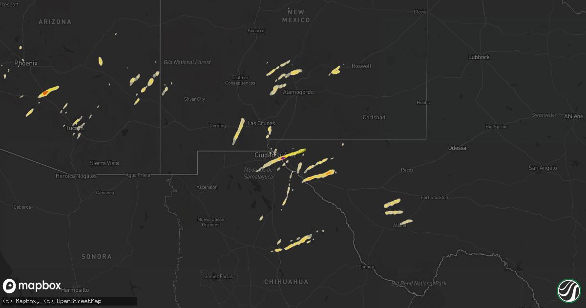
October 6 map
$229
one time, instant access
Download today. No call, no setup
Keep the $229
Bought the map and want the full workflow? Apply the entire $229 to a subscription within 7 days. None of it is wasted.
Every map, not just this one
This buys you this map. Subscription and you get every map we run, in the markets you choose from a few cities to whole states to nationwide. Plus real-time alerts the moment a storm fires.
Contact data
Name, contact info, occupancy, even credit band for addresses in the footprint. You go from where it hit to who to call.
Become the source they trust
Unlimited branding weather history reports on demand. You already have the documented answer ready for the property owner, and you are the one who showed up with it.
Property data and RoofTrace estimates
Pull up any address you have got, its value and the exact code rules for that jurisdiction, straight from One Click Code. Then RoofTrace estimates the squares, pitch, and roof value, priced the way you price.
States Impacted by Hail Map on October 6, 2015
Storm reports
Arizona
| Date | Description |
|---|---|
| 10/06/20155:40 PM CDT | Coolidge asos reports 52 kt gust |
| 10/06/20155:21 PM CDT | Half dollar size hail reported at pinal county fair grounds |
| 10/06/20155:10 PM CDT | Golf ball size hail reported east of casa grande |
| 10/06/20152:43 PM CDT | A local report indicates 1.00 inch wind near 5 NW SAGUARO NATIONAL P |
| 10/06/20152:40 PM CDT | Trees blown over at kenyon and sarnoff |
| 10/06/20152:40 PM CDT | A local report indicates 1.00 inch wind near 5 WNW CATALINA FOOTHILL |
Colorado
| Date | Description |
|---|---|
| 10/06/20155:00 PM CDT | A local report indicates 1.75 inch wind near 11 NNW RAMAH |
Texas
| Date | Description |
|---|---|
| 10/06/20154:36 PM CDT | Love truck stop cleark reported hail |
| 10/06/20154:35 PM CDT | A local report indicates 1.75 inch wind near SOCORRO |
| 10/06/20154:35 PM CDT | Kanazo rd. In horizon city |
| 10/06/20154:29 PM CDT | Received mping report of 1.0 inch hail near horizon city |
Cities Impacted by Hail Map on October 6, 2015
- Tucson, AZ
- Mescalero, NM
- Morenci, AZ
- Clifton, AZ
- Fort Davis, TX
- El Paso, TX
- Eloy, AZ
- Coolidge, AZ
- Florence, AZ
- Casa Grande, AZ
- Fort Hancock, TX
- Tinnie, NM
- San Elizario, TX
- Anthony, NM
- Tuba City, AZ
- Leupp, AZ
- Ramah, CO
- Phoenix, AZ
- Peoria, AZ
- Glendale, AZ
- Truth Or Consequences, NM
- Elbert, CO
- Agate, CO
- Calhan, CO
- Simla, CO
- Tularosa, NM
- Fort Bliss, TX
- Elizabeth, CO
- Kiowa, CO
- Marathon, TX
- Alpine, TX
- San Carlos, AZ
- Berino, NM
- Mesquite, NM
- Valley Farms, AZ
- Clint, TX
- Winslow, AZ
- Maricopa, AZ
- Mount Lemmon, AZ
- Vado, NM
- Salt Flat, TX
- Colorado Springs, CO
- Picacho, NM
- Marana, AZ
- Ganado, AZ
- Tornillo, TX
- Buckeye, AZ
- Goodyear, AZ
- Buckhorn, NM
- Balmorhea, TX
- White Sands Missile Range, NM
- Stratford, TX
- Sierra Blanca, TX
- Genoa, CO
- Peyton, CO
- Goodwell, OK
- Texhoma, OK
- Safford, AZ
- Sells, AZ
- Laveen, AZ