Hail Map on October 3, 2019
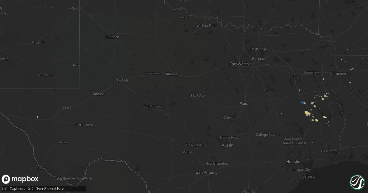
Get this storm
October 3 map
$229
one time, instant access
Download today. No call, no setup
Keep the $229
Bought the map and want the full workflow? Apply the entire $229 to a subscription within 7 days. None of it is wasted.
Every map, not just this one
This buys you this map. Subscription and you get every map we run, in the markets you choose from a few cities to whole states to nationwide. Plus real-time alerts the moment a storm fires.
Contact data
Name, contact info, occupancy, even credit band for addresses in the footprint. You go from where it hit to who to call.
Become the source they trust
Unlimited branding weather history reports on demand. You already have the documented answer ready for the property owner, and you are the one who showed up with it.
Property data and RoofTrace estimates
Pull up any address you have got, its value and the exact code rules for that jurisdiction, straight from One Click Code. Then RoofTrace estimates the squares, pitch, and roof value, priced the way you price.
States Impacted by Hail Map on October 3, 2019
Storm reports
Texas
| Date | Description |
|---|---|
| 10/03/20196:11 PM CDT | Tree and power line down reported on fm 1911s about 3 miles south of alto. |
| 10/03/20194:50 PM CDT | Tree reported down 10 miles west of center on hwy 7. |
| 10/03/201912:40 AM CDT | At 539 PM CDT, severe thunderstorms were located along a line extending from near Sacul to near Nacogdoches, moving southwest at 25 mph. HAZARD...60 mph wind gusts and penny size hail. SOURCE...Radar indicated. IMPACT...Expect damage to roofs, siding, and trees. Locations impacted include... Lufkin, Nacogdoches, Hudson, Alto, Wells, Morrill, Woden, Pollok, Forest, Douglass, Trawick, Burke, Cushing, Appleby, Mount Enterprise, Clawson, Central, Redland, Linwood and Lilbert. |
| 10/02/201911:42 PM CDT | At 442 PM CDT, a severe thunderstorm was located 7 miles northeast of Martinsville, or 10 miles southwest of Center, moving west southwest at 20 mph. HAZARD...60 mph wind gusts and penny size hail. SOURCE...Radar indicated. IMPACT...Expect damage to roofs, siding, and trees. Locations impacted include... Garrison, Melrose, Martinsville, Neuville, Appleby, Arcadia, Jericho and Stockman. |
Mississippi
| Date | Description |
|---|---|
| 10/03/20193:21 PM CDT | Tree down on utility equipment along friendship rd. |
| 10/02/201910:20 PM CDT | At 320 PM CDT, a severe thunderstorm was located over Byram, moving west at 15 mph. HAZARD...60 mph wind gusts. SOURCE...Radar indicated. IMPACT...Expect damage to roofs, siding, and trees. This severe thunderstorm will be near... Byram around 325 PM CDT. Terry around 340 PM CDT. |
Louisiana
| Date | Description |
|---|---|
| 10/03/20196:17 PM CDT | Power lines were downed on mccutchen avenue between trigger trail and lucille street. There were other reports of power lines downed throughout shreveport. |
| 10/03/20194:56 PM CDT | Tree down on penal farm road south of minden. |
| 10/03/20194:49 PM CDT | Numerous trees and large limbs were downed. Street signs were blown over on highway 531... And power poles were leaning in town. The entire city of minden was without p |
| 10/02/201911:49 PM CDT | At 449 PM CDT, a severe thunderstorm was located over Dixie Inn, or near Minden, moving west at 25 mph. HAZARD...60 mph wind gusts and penny size hail. SOURCE...Radar indicated. IMPACT...Expect damage to roofs, siding, and trees. Locations impacted include... Minden, Sibley, Doyline, Dubberly, Dixie Inn, Heflin, Gilark, Noles Landing, Lake Bistineau North and Ogden. |
Pennsylvania
| Date | Description |
|---|---|
| 10/03/201912:12 AM CDT | At 511 PM EDT, a severe thunderstorm was located over Brockport, moving east at 45 mph. HAZARD...60 mph wind gusts and penny size hail. SOURCE...Radar indicated. IMPACT...Expect damage to trees, roofs, and siding. This severe thunderstorm will be near... Medix Run and Force around 530 PM EDT.Other locations impacted by this severe thunderstorm includeWeedville. |
| 10/02/201911:09 PM CDT | At 408 PM EDT, a severe thunderstorm was located over Medix Run, moving east at 40 mph. HAZARD...60 mph wind gusts and quarter size hail. SOURCE...Radar indicated. IMPACT...Hail damage to vehicles is expected. Expect wind damage to trees, roofs, and siding. Locations impacted include... St. Marys, Benezette, Stevenson Dam, Hicks Run, Medix Run and Driftwood. |
Cities Impacted by Hail Map on October 3, 2019
- Timpson, TX
- Center, TX
- Wells, TX
- Alto, TX
- Corrigan, TX
- Coushatta, LA
- Hall Summit, LA
- Garrison, TX
- Jasper, TX
- Zavalla, TX
- Nacogdoches, TX
- Chester, TX
- Diboll, TX
- Apple Springs, TX
- Lufkin, TX
- De Berry, TX
- Colmesneil, TX
- Shelbyville, TX
- Taylor, AR
- Stamps, AR
- Centerville, TX
- Jacksonville, TX
- Haynesville, LA
- Byram, MS
- Florence, MS
- Richland, MS
- Sibley, LA
- Minden, LA
- Shreveport, LA