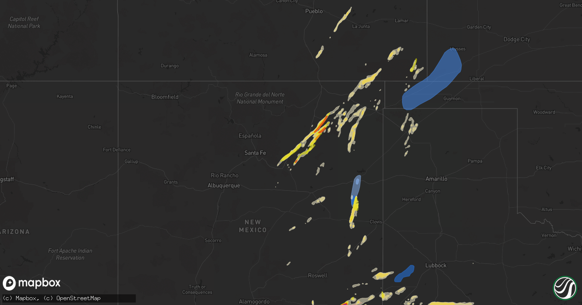
Hail Map on October 2, 2023
Get this storm
October 2 map
$229
one time, instant access
Download today. No call, no setup
Keep the $229
Bought the map and want the full workflow? Apply the entire $229 to a subscription within 7 days. None of it is wasted.
Every map, not just this one
This buys you this map. Subscription and you get every map we run, in the markets you choose from a few cities to whole states to nationwide. Plus real-time alerts the moment a storm fires.
Contact data
Name, contact info, occupancy, even credit band for addresses in the footprint. You go from where it hit to who to call.
Become the source they trust
Unlimited branding weather history reports on demand. You already have the documented answer ready for the property owner, and you are the one who showed up with it.
Property data and RoofTrace estimates
Pull up any address you have got, its value and the exact code rules for that jurisdiction, straight from One Click Code. Then RoofTrace estimates the squares, pitch, and roof value, priced the way you price.
States Impacted by Hail Map on October 2, 2023
Storm reports
New Mexico
| Date | Description |
|---|---|
| 10/02/20236:39 PM CDT | Corrects previous report. Golf ball sized hail observed in walnut canyon in carlsbad caverns national park. |
| 10/02/20236:39 PM CDT | Golf ball sized hail observed in walnut canyon in carlsbad caverns national park. |
| 10/02/20236:01 PM CDT | Asos station ktcc tucumcari muni airport. |
| 10/02/20235:41 PM CDT | Single wide trailer fully collapsed. No injuries reported. Time estimated from radar. |
| 10/02/20235:30 PM CDT | Mesonet station fw9688 jal. |
| 10/02/20234:41 PM CDT | Wind gusts at or above 60 mph. |
| 10/02/20232:50 PM CDT | Copious amounts of nickel to quarter sized hail required nmdot snow plows to be dispatched along interstate 25. |
| 10/02/20232:46 PM CDT | Quarter sized hail and wind gusts over 60 mph along us285 northwest of carlsbad. |
| 10/02/20232:37 PM CDT | Relayed report from nmdot employee... Tennis ball size hail on us285. Time estimated from radar. |
| 10/02/20232:37 PM CDT | Lots of nickel to quarter sized hail that accumulated to about 3 inches deep in some areas. |
| 10/02/20232:36 PM CDT | Golf ball sized hail along us285. Time estimated from radar. |
| 10/02/20232:11 PM CDT | Golfball size hail |
| 10/01/20237:10 PM CDT | Measured 60 mph wind gust northeast of white sands. |
| 10/01/20237:00 PM CDT | Measured 61 mph wind gust due to strong thunderstorm just southeast of white sands. |
| 10/01/20237:00 PM CDT | Measured 59 mph wind gust due to strong thunderstorm southeast of white sands. |
Nebraska
| Date | Description |
|---|---|
| 10/02/20236:22 PM CDT | Many tree branches downed due to estimated wind gusts 60-80 mph. |
| 10/01/20237:33 PM CDT | A local report indicates 1.00 inch wind near 15 NNW Hay Springs |
| 10/01/20237:33 PM CDT | A local report indicates 60 MPH wind near 15 NNW Hay Springs |
| 10/01/20237:25 PM CDT | A local report indicates 1.00 inch wind near 5 SW Hay Springs |
Kansas
| Date | Description |
|---|---|
| 10/01/202311:08 PM CDT | Mesonet station cw8810 elkhart. |
South Dakota
| Date | Description |
|---|---|
| 10/01/20239:21 PM CDT | Mping report |
| 10/01/20238:56 PM CDT | A local report indicates 1.50 inch wind near 7 NNE Ellsworth AFB |
| 10/01/20238:53 PM CDT | A local report indicates 1.25 inch wind near 7 NNE Ellsworth AFB |
| 10/01/20238:32 PM CDT | A local report indicates 1.00 inch wind near 2 E Dwtn Rapid City |
| 10/01/20238:32 PM CDT | A local report indicates 1.00 inch wind near 3 NE Dwtn Rapid City |
| 10/01/20237:57 PM CDT | Time estimated from radar. |
Colorado
| Date | Description |
|---|---|
| 10/02/20236:39 PM CDT | Asos station kcos colorado springs airport. |
| 10/02/20236:25 PM CDT | Mesonet station fw6605 founatin. |
| 10/02/20237:31 AM CDT | Likely outflow from storms north of westcliffe. |
Texas
| Date | Description |
|---|---|
| 10/02/20234:20 PM CDT | A local report indicates 2.75 inch wind near Pecos |
| 10/02/20234:00 AM CDT | Mesonet station fluvanna 3w. |
| 10/02/202312:40 AM CDT | Located at university blvd and moss ave. |
| 10/01/20238:08 PM CDT | Severe gusts began at 803 pm and ended at 808 pm. |
| 10/01/20237:36 PM CDT | Mesonet station fw9691 mentone. Time estimated by radar. |
| 10/01/20237:20 PM CDT | Hail observed at the tornado gas plant. |
Cities Impacted by Hail Map on October 2, 2023
- Carlsbad, NM
- Las Vegas, NM
- Artesia, NM
- Watrous, NM
- Valmora, NM
- Wagon Mound, NM
- Ocate, NM
- Pecos, TX
- Balmorhea, TX
- Pyote, TX
- Barstow, TX
- Springer, NM
- Mentone, TX
- Walsh, CO
- Floyd, NM
- Melrose, NM
- Lovington, NM
- Mcalister, NM
- Jal, NM
- Clayton, NM
- Crowley, CO
- Ordway, CO
- Grenville, NM
- Roy, NM
- Dalhart, TX
- San Jose, NM
- Olney Springs, CO
- Capitan, NM
- Elida, NM
- Fowler, CO
- Manzanola, CO
- Model, CO
- Maljamar, NM
- Tucumcari, NM
- Trementina, NM
- Denver City, TX
- Angora, NE
- Alliance, NE
- Hobbs, NM
- Plains, TX
- Broadwater, NE
- Harrisburg, NE
- Gering, NE
- Mitchell, NE
- Scottsbluff, NE
- White Sands Missile Range, NM
- Organ, NM
- Las Cruces, NM
- Cloudcroft, NM
- Hay Springs, NE
- Chadron, NE
- Pine Ridge, SD
- Custer, SD
- Hot Springs, SD
- Edgemont, SD
- Manderson, SD
- Kyle, SD
- Pringle, SD
- Oral, SD
- Whiteface, TX
- Sundown, TX
- Levelland, TX
- Buffalo Gap, SD
- Hermosa, SD
- Rapid City, SD
- Keystone, SD
- Wink, TX
- Ellsworth Afb, SD
- Box Elder, SD
- Piedmont, SD
- Gordon, NE
- Sturgis, SD
- Fairburn, SD
- New Underwood, SD
- Union Center, SD
- Kermit, TX
- Kimball, NE
- Caputa, SD
- Potter, NE
- Bridgeport, NE
- Dix, NE
- Gladstone, NM
- Pritchett, CO
- Springfield, CO
- Corona, NM
- Garita, NM
- Rushville, NE
- Tokio, TX
- Dalton, NE
- Gurley, NE
- Mills, NM
- Oshkosh, NE
- Lakeside, NE
- Ellsworth, NE
- Bingham, NE
- Merriman, NE
- Oglala, SD
- Hemingford, NE
- Sidney, NE
- Hartley, TX
- Seminole, TX
- Akron, CO
- Portales, NM
- Loving, NM
- Cuervo, NM
- Kim, CO
- Folsom, NM
- Mosquero, NM
- Des Moines, NM
- Harrison, NE
- Bayard, NE
- Yeso, NM
- Eunice, NM
- Santa Rosa, NM
- Andrews, TX
- Boise City, OK
- Campo, CO
- Odessa, TX
- Goldsmith, TX
- Brownfield, TX
- Roswell, NM
- Keyes, OK
- Seagraves, TX
- Loop, TX
- Kadoka, SD
- Tatum, NM
- Fairdale, ND
- Milton, ND
- Montpelier, ND
- Crystal, ND
- Cavalier, ND
- Hensel, ND
- Adams, ND
- Morton, TX
- Edinburg, ND
- Mountain, ND
- Robinson, ND
- Lamesa, TX
- Towner, ND
- Devils Lake, ND
- Gail, TX
- Fluvanna, TX
- Underwood, ND
- Wounded Knee, SD
- Snyder, TX
- Fort Morgan, CO
- Wishek, ND
- Pembina, ND
- Hamilton, ND
- Bathgate, ND
- Welch, TX
- Neche, ND
- Lawton, ND
- Goodwell, OK
- Moscow, KS
- Guymon, OK
- Johnson, KS
- Texhoma, OK
- Hugoton, KS
- Elkhart, KS
- Ulysses, KS
- Rolla, KS
- Richfield, KS