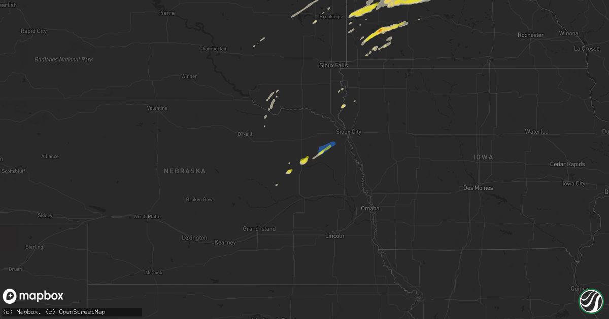
Hail Map on September 29, 2023
Get this storm
September 29 map
$229
one time, instant access
Download today. No call, no setup
Keep the $229
Bought the map and want the full workflow? Apply the entire $229 to a subscription within 7 days. None of it is wasted.
Every map, not just this one
This buys you this map. Subscription and you get every map we run, in the markets you choose from a few cities to whole states to nationwide. Plus real-time alerts the moment a storm fires.
Contact data
Name, contact info, occupancy, even credit band for addresses in the footprint. You go from where it hit to who to call.
Become the source they trust
Unlimited branding weather history reports on demand. You already have the documented answer ready for the property owner, and you are the one who showed up with it.
Property data and RoofTrace estimates
Pull up any address you have got, its value and the exact code rules for that jurisdiction, straight from One Click Code. Then RoofTrace estimates the squares, pitch, and roof value, priced the way you price.
States Impacted by Hail Map on September 29, 2023
Storm reports
South Dakota
| Date | Description |
|---|---|
| 09/29/20234:19 PM CDT | Multiple social media reports of nickel to quarter size hail in elkton... Sd. Time estimated via radar. |
Minnesota
| Date | Description |
|---|---|
| 09/29/20235:20 PM CDT | Mostly peas to walnut sized hail reported just south of lake shetek. |
| 09/29/20234:55 PM CDT | Public report of quarter sized hail. Time estimated via radar. |
| 09/29/20234:53 PM CDT | A trained spotter reported half dollar sized hail. Time estimated via radar. |
| 09/29/20234:51 PM CDT | Social media report of nickel to quarter sized hail. Time estimated via radar. |
| 09/29/20238:55 AM CDT | Quarter sized hail at intersection of highway 35 and 113. |
| 09/29/20238:20 AM CDT | A local report indicates 1.75 inch wind near Barnesville |
| 09/28/202310:14 PM CDT | Measured via the hennepin west mesonet. |
| 09/28/202310:06 PM CDT | Trees down near beebe lake park. |
| 09/28/202310:01 PM CDT | Report on nwschat of multiple trees down. Also... Reports of significant damage to multiple barns |
| 09/28/20239:45 PM CDT | 8 to 10 inch tree limbs down north of montrose. |
| 09/28/20238:53 PM CDT | Asos station kmsp minneapolis-st. Paul ap. |
| 09/28/20238:35 PM CDT | Pictures shared on social media of a large uprooted pine tree in residents yard. |
| 09/28/20238:30 PM CDT | Picture shared on social media of medium sized... Uprooted tree. Time estimated from radar. |
| 09/28/20237:50 PM CDT | Delayed report - trees down near dean lake. Time estimated from radar. |
| 09/28/20237:45 PM CDT | Delayed report - trees down in marysville township. Time esimated from radar. |
| 09/28/20237:35 PM CDT | Mesonet station mn022 t.h.7 - new germany - mp 161. |
Nebraska
| Date | Description |
|---|---|
| 09/28/20239:00 PM CDT | Tree branch down in road. |
| 09/28/20238:55 PM CDT | A local report indicates 78 MPH wind near 2 E Wayne |
| 09/28/20238:40 PM CDT | Report from mping: quarter |
| 09/28/20238:38 PM CDT | Report from mping: quarter |
| 09/28/20238:37 PM CDT | 0.25 to 1 inch hail. |
| 09/28/20238:36 PM CDT | Approximately 60 ft tall trees uprooted and power lines down. Time estimated from radar. |
| 09/28/20238:30 PM CDT | Several reports of quarter sized hail in norfolk. |
Texas
| Date | Description |
|---|---|
| 09/29/202312:43 AM CDT | West texas mesonet station. |
| 09/28/202311:15 PM CDT | Measured by the west texas mesonet. |
Cities Impacted by Hail Map on September 29, 2023
- Andover, SD
- Groton, SD
- Langford, SD
- Wolverton, MN
- Barnesville, MN
- Hawley, MN
- Lake Park, MN
- Audubon, MN
- Detroit Lakes, MN
- Callaway, MN
- Ogema, MN
- White Earth, MN
- Waubun, MN
- Ponsford, MN
- Naytahwaush, MN
- Forman, ND
- Dante, SD
- Avon, SD
- Lidgerwood, ND
- Walcott, ND
- Christine, ND
- Milnor, ND
- Rutland, ND
- Fergus Falls, MN
- Breckenridge, MN
- Mantador, ND
- Wyndmere, ND
- Tyndall, SD
- Springfield, SD
- Colfax, ND
- Barney, ND
- Wahpeton, ND
- Mooreton, ND
- Cayuga, ND
- Hankinson, ND
- Havana, ND
- Sabin, MN
- Moorhead, MN
- Niobrara, NE
- Verdigre, NE
- Plankinton, SD
- Britton, SD
- Claremont, SD
- Rothsay, MN
- Pelican Rapids, MN
- Tripp, SD
- Kent, MN
- Chandler, MN
- Lake Wilson, MN
- Lake Benton, MN
- Arco, MN
- Tyler, MN
- Slayton, MN
- Lynd, MN
- Minneota, MN
- Ghent, MN
- Currie, MN
- Tracy, MN
- Marshall, MN
- Walnut Grove, MN
- Westbrook, MN
- Revere, MN
- Arlington, SD
- Volga, SD
- Letcher, SD
- Woonsocket, SD
- Hialeah, FL
- Oldham, SD
- Edgerton, MN
- Lake Norden, SD
- Lake Preston, SD
- De Smet, SD
- Ivanhoe, MN
- Lamberton, MN
- Belview, MN
- Seaforth, MN
- Redwood Falls, MN
- Morton, MN
- Franklin, MN
- Olivia, MN
- Morgan, MN
- Bird Island, MN
- Fairfax, MN
- Hector, MN
- Buffalo Lake, MN
- Cosmos, MN
- Hutchinson, MN
- Stewart, MN
- Litchfield, MN
- Brownton, MN
- Glencoe, MN
- Gibbon, MN
- Silver Lake, MN
- Lester Prairie, MN
- Plato, MN
- Winsted, MN
- Norwood Young America, MN
- Young America, MN
- Cokato, MN
- New Germany, MN
- Howard Lake, MN
- Mayer, MN
- Watertown, MN
- Waconia, MN
- Montrose, MN
- Waverly, MN
- Delano, MN
- Saint Bonifacius, MN
- Mound, MN
- Maple Plain, MN
- Excelsior, MN
- Madison, NE
- Lindsay, NE
- Norfolk, NE
- Stanton, NE
- Hoskins, NE
- Wayne, NE
- Wakefield, NE
- Emerson, NE
- Minneapolis, MN
- Saint Paul, MN
- Mendota, MN
- Littlefield, TX
- Freeport, MN
- Lovington, NM
- Paynesville, MN
- Belgrade, MN
- Fulda, MN
- Kenneth, MN
- Denver City, TX
- Plains, TX
- Hawarden, IA
- Chatsworth, IA
- Elk Point, SD
- Akron, IA
- Avoca, MN
- Loving, NM
- Hudson, SD
- Canton, SD
- Springfield, MN
- Sleepy Eye, MN
- Vesta, MN
- Lismore, MN
- Wilmont, MN
- Woodstock, MN
- Danube, MN
- Renville, MN
- New London, MN
- Willmar, MN
- Pilger, NE
- Winthrop, MN
- Buffalo, MN
- Adrian, MN
- Magnolia, MN
- Wood Lake, MN
- Cottonwood, MN
- Meadow Grove, NE
- Echo, MN
- Wabasso, MN
- Milroy, MN
- Russell, MN
- Newman Grove, NE
- Pennock, MN
- Raymond, MN
- Estelline, SD
- Sanborn, MN
- Albion, NE
- Lucan, MN
- Ireton, IA
- Benson, MN
- Spicer, MN
- Cambridge, MN
- Isanti, MN
- Grandy, MN
- Stanchfield, MN
- Somerset, WI
- Alcester, SD
- Tatum, NM
- Sacred Heart, MN
- Levelland, TX
- Hugo, MN
- Elizabeth, MN
- Blomkest, MN
- Murdock, MN
- Anton, TX
- Rockford, MN
- Loretto, MN
- Muleshoe, TX
- Bovina, TX
- Hamel, MN
- Rogers, MN
- Brookings, SD
- Dayton, MN
- Maple Grove, MN
- Osseo, MN
- Dovray, MN
- Danvers, MN
- Bruce, SD
- Holland, MN
- Stillwater, MN
- North Branch, MN
- Sudan, TX
- New Richmond, WI
- Worthington, MN
- Pipestone, MN
- Hanover, MN
- Long Lake, MN
- Champlin, MN
- Reading, MN
- Milan, MN
- Appleton, MN
- Farwell, TX
- Wayzata, MN
- Ruthton, MN
- Hanley Falls, MN
- Winside, NE
- Rush City, MN
- Milaca, MN
- Carver, MN
- Braham, MN