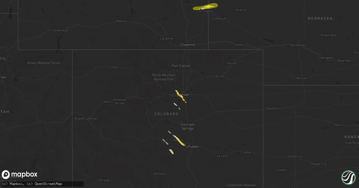
Hail Map on September 29, 2015
Get this storm
September 29 map
$229
one time, instant access
Download today. No call, no setup
Keep the $229
Bought the map and want the full workflow? Apply the entire $229 to a subscription within 7 days. None of it is wasted.
Every map, not just this one
This buys you this map. Subscription and you get every map we run, in the markets you choose from a few cities to whole states to nationwide. Plus real-time alerts the moment a storm fires.
Contact data
Name, contact info, occupancy, even credit band for addresses in the footprint. You go from where it hit to who to call.
Become the source they trust
Unlimited branding weather history reports on demand. You already have the documented answer ready for the property owner, and you are the one who showed up with it.
Property data and RoofTrace estimates
Pull up any address you have got, its value and the exact code rules for that jurisdiction, straight from One Click Code. Then RoofTrace estimates the squares, pitch, and roof value, priced the way you price.
States Impacted by Hail Map on September 29, 2015
Storm reports
Colorado
| Date | Description |
|---|---|
| 09/29/20156:20 PM CDT | A local report indicates 1.00 inch wind near 1 ENE FLORENCE |
| 09/29/20156:15 PM CDT | A local report indicates 1.25 inch wind near 1 ENE HIGHLANDS RANCH |
| 09/29/20156:05 PM CDT | A local report indicates 1.00 inch wind near 1 W CENTENNIAL |
| 09/29/20155:55 PM CDT | A local report indicates 1.50 inch wind near 2 WNW LAKEWOOD |
| 09/29/20155:47 PM CDT | A local report indicates 1.00 inch wind near 1 W LAKEWOOD |
| 09/29/20155:28 PM CDT | A local report indicates 1.00 inch wind near 9 N GOLDEN |
| 09/28/20158:55 PM CDT | Hail from thunderstorms evening 9/29/15. Precipitation 0.27 inch. |
Maryland
| Date | Description |
|---|---|
| 09/28/201511:13 PM CDT | Tree down on putnam rd. Multiple large tree limbs down throughout the county. |
| 09/28/201510:30 PM CDT | 5 large pine trees knocked down |
| 09/28/20159:02 PM CDT | Ef0 confirmed from laurel to scaggsville md sep 29. |
New Mexico
| Date | Description |
|---|---|
| 09/29/20155:30 PM CDT | A local report indicates 1.25 inch wind near 7 SSW YATES |
Pennsylvania
| Date | Description |
|---|---|
| 09/28/201511:40 PM CDT | Ef-1 tornado confirmed in east hempfield twp. Max winds 90 to 100 mph. |
| 09/28/201511:35 PM CDT | Multiple reports of trees down into buildings and roofs blown off in east hempfield township. Route 30 closed due to roof debris on road. |
| 09/28/201511:30 PM CDT | Large trees down |
Florida
| Date | Description |
|---|---|
| 09/29/20159:40 AM CDT | Survey by collier county emergency management staff found roof and carport damage to at least four mobile homes in the cape sable lakes community south of radio road. S |
| 09/29/20159:05 AM CDT | Video obtained via social media depicts waterspout coming ashore near the windsor condominums off bay colony drive. Several branches and other debris seen flying before |
Wyoming
| Date | Description |
|---|---|
| 09/28/20157:03 PM CDT | A local report indicates 1.00 inch wind near LINGLE |
| 09/28/20157:02 PM CDT | A local report indicates 1.00 inch wind near LINGLE |
Virginia
| Date | Description |
|---|---|
| 09/28/20158:00 PM CDT | Multiple trees down....two hvac units dislodged in area of east market st and catoctin cir |
Cities Impacted by Hail Map on September 29, 2015
- Denver, CO
- Englewood, CO
- Golden, CO
- Penrose, CO
- Florence, CO
- Canon City, CO
- Torrington, WY
- Harrison, NE
- Lingle, WY
- Westcliffe, CO
- Sedalia, CO
- Cotopaxi, CO
- Gladstone, NM
- Marion Junction, AL
- Springer, NM
- Roy, NM
- Littleton, CO
- Conifer, CO
- Parker, CO
- Lone Tree, CO
- Arvada, CO
- Wheat Ridge, CO
- Selma, AL
- Pueblo, CO
- Fort Laramie, WY
- Morrill, NE
- Yoder, WY
- Jay Em, WY