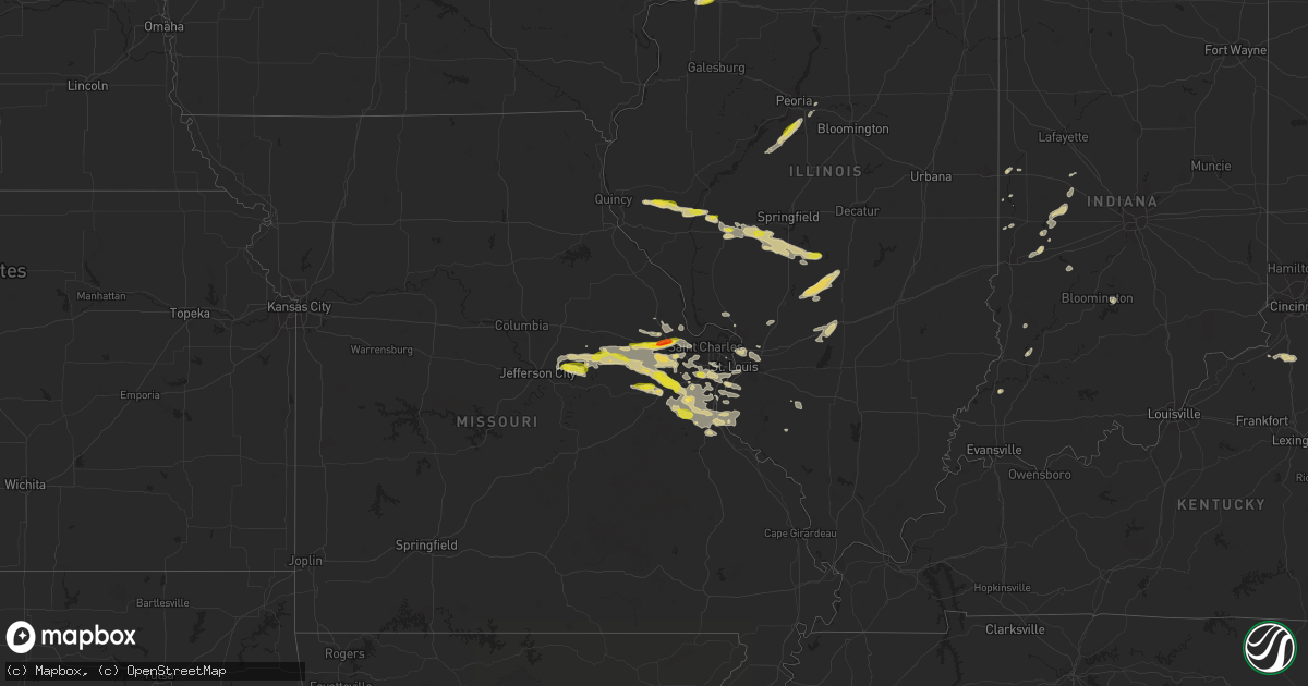
Hail Map on September 26, 2023
Get this storm
September 26 map
$229
one time, instant access
Download today. No call, no setup
Keep the $229
Bought the map and want the full workflow? Apply the entire $229 to a subscription within 7 days. None of it is wasted.
Every map, not just this one
This buys you this map. Subscription and you get every map we run, in the markets you choose from a few cities to whole states to nationwide. Plus real-time alerts the moment a storm fires.
Contact data
Name, contact info, occupancy, even credit band for addresses in the footprint. You go from where it hit to who to call.
Become the source they trust
Unlimited branding weather history reports on demand. You already have the documented answer ready for the property owner, and you are the one who showed up with it.
Property data and RoofTrace estimates
Pull up any address you have got, its value and the exact code rules for that jurisdiction, straight from One Click Code. Then RoofTrace estimates the squares, pitch, and roof value, priced the way you price.
States Impacted by Hail Map on September 26, 2023
Storm reports
Louisiana
| Date | Description |
|---|---|
| 09/26/20235:35 PM CDT | Awos station kopl opelousas. |
| 09/26/20234:57 PM CDT | Asos station klch lake charles. |
Missouri
| Date | Description |
|---|---|
| 09/26/20235:25 PM CDT | Via twitter with picture included: 1 inch hail estimated from picture. |
| 09/26/20234:11 PM CDT | Via twitter with picture included: 1 inch hail estimated from picture. |
| 09/25/20239:40 PM CDT | Report relayed by kmov. |
| 09/25/20239:26 PM CDT | A local report indicates 1.00 inch wind near Pacific |
| 09/25/20239:11 PM CDT | A local report indicates 1.00 inch wind near 1 E Washington |
| 09/25/20238:43 PM CDT | 2 miles nw of wentzville city center. |
| 09/25/20238:40 PM CDT | Via facebook with picture included: 1.75 inch diameter hail measured with ruler. |
| 09/25/20238:40 PM CDT | Via twitter with picture included: 1.5 inch hail estimated from picture. Damage to siding and window screens on pictured home. |
| 09/25/20238:40 PM CDT | Via facebook with picture included: multiple hailstones ranging from 1 to 1.5 inches estimated using quarter in picture. |
| 09/25/20238:40 PM CDT | Via twitter with pictures included: golf ball sized hail estimated from picture damaged siding and window screens in numerous homes on northern side of wentzville. Time |
| 09/25/20238:38 PM CDT | Via facebook with picture included: 1 inch diameter hail measured with ruler. |
| 09/25/20238:38 PM CDT | Trained spotter reported ping pong ball sized hail halfway between foristell and wentzville. |
| 09/25/20238:24 PM CDT | Via facebook with picture included: 1 inch diameter hail measured with ruler. |
| 09/25/20237:20 PM CDT | First responders in rhineland mo reported quarter sized hail covering the ground. |
Illinois
| Date | Description |
|---|---|
| 09/26/20235:14 PM CDT | Delayed report. At the intersection of u.s. 6 and i74. |
| 09/25/202311:00 PM CDT | Nickel to quarter sized hail. |
| 09/25/202311:00 PM CDT | Tree limbs down... Size unknown. |
| 09/25/202310:50 PM CDT | Tree down near townline and towerline road. Size unknown. |
| 09/25/202310:45 PM CDT | 5-6 inch tree limbs down. Time estimated by radar. |
Florida
| Date | Description |
|---|---|
| 09/26/20236:37 PM CDT | The sanford international airport reported a wind gust of 67 mph/ 58 kts out of the west northwest. |
| 09/26/20234:20 PM CDT | Fpl reported that a tree or branch damaged electrical equipment near sherry lane. The time of damage was based on radar. |
| 09/26/20234:05 PM CDT | [landspout] public report of a landspout or a brief tornado touchdown just west of the shands bridge near green cove springs. Time of event based on radar data. |
| 09/26/20233:40 PM CDT | [landspout] action news jax posted a public video of a landspout or a brief tornado touchdown in the vicinity of lake asbury. No immediate reports of damage were avail |
| 09/26/20233:40 PM CDT | [landspout] this an updated to the previous report of a landspout near lake asbury. A witness reported that the spout lasted for 3-5 minutes and tracked wsw to ene for |
Texas
| Date | Description |
|---|---|
| 09/26/20236:10 PM CDT | 1.0 inch... Quarter size hail reported from the public view social media. Location near fort bliss/central el paso vicinity. |
| 09/25/20237:41 PM CDT | Multiple power poles were downed by strong thunderstorm wind gusts in humble. |
Iowa
| Date | Description |
|---|---|
| 09/26/20233:15 PM CDT | Updated the previous funnel cloud report. Emergency management confirms that there was a brief tornado of unknown intensity. Reports of ground circulation lofting corn |
Cities Impacted by Hail Map on September 26, 2023
- Chambersburg, IL
- Meredosia, IL
- Clayton, IL
- Mount Sterling, IL
- Versailles, IL
- Chapin, IL
- Concord, IL
- Dell City, TX
- Salt Flat, TX
- Corona, NM
- Arenzville, IL
- Jacksonville, IL
- Loami, IL
- New Berlin, IL
- Alexander, IL
- Waverly, IL
- Crossroads, NM
- Tatum, NM
- Greencastle, IN
- Covington, IN
- Brazil, IN
- Dixon, IA
- Donahue, IA
- New Liberty, IA
- Stockton, IA
- Calamus, IA
- Walcott, IA
- Griggsville, IL
- Darlington, IN
- Knightsville, IN
- Spencer, IN
- Poland, IN
- Washington, IN
- Divernon, IL
- Roachdale, IN
- Rockville, IN
- Russellville, IN
- Ladoga, IN
- Harmony, IN
- Staunton, IN
- Patoka, IN
- Carbon, IN
- Bluffs, IL
- Bloomington, IN
- Clinton, IN
- Hillsdale, IN
- Kingman, IN
- Veedersburg, IN
- Weed, NM
- Nashville, IN
- Cayuga, IN
- Dana, IN
- Carlisle, IN
- Sandborn, IN
- Tinnie, NM
- Sparta, IL
- Crawfordsville, IN
- New Ross, IN
- Rogers, NM
- Hope, NM
- Liberty, IL
- Cedar Hill, MO
- Dittmer, MO
- Santa Rosa, NM
- Fort Sumner, NM
- El Paso, TX
- Fort Bliss, TX
- Sanford, FL
- Lake Mary, FL
- Deltona, FL
- Morrisonville, IL
- Palmer, IL
- Taylorville, IL
- Chamois, MO
- Bonnots Mill, MO
- Tebbetts, MO
- Morrison, MO
- Coal Valley, IL
- Moline, IL
- East Moline, IL
- Rhineland, MO
- Hermann, MO
- Lovington, NM
- Marthasville, MO
- Berger, MO
- Warrenton, MO
- Wright City, MO
- Truesdale, MO
- Foristell, MO
- Wentzville, MO
- O'Fallon, MO
- Washington, MO
- Augusta, MO
- Labadie, MO
- Gray Summit, MO
- Villa Ridge, MO
- Pacific, MO
- Catawissa, MO
- Leslie, MO
- Beaufort, MO
- Union, MO
- Hillsboro, MO
- Green Valley, IL
- Pekin, IL
- Tremont, IL
- Boise City, OK
- Saint Clair, MO
- Lonedell, MO
- Robertsville, MO
- Coulterville, IL
- Willard, NM
- Milan, IL
- Rock Island, IL
- Fort Davis, TX
- Ashton, IL
- Oakdale, IL
- Nashville, IL
- Addieville, IL
- Richfield, KS
- Linn, MO
- Steedman, MO
- Mokane, MO
- Magdalena, NM
- Encino, NM
- Granite City, IL
- Lake Saint Louis, MO
- Rochelle, IL
- Moscow Mills, MO
- Virden, IL
- Auburn, IL
- Sunland Park, NM
- Valley Park, MO
- Ballwin, MO
- Valentine, TX
- Franklin, IL
- Portland, MO
- Defiance, MO
- Dry Ridge, KY
- Williamstown, KY
- Fenton, MO
- Murrayville, IL
- Milnesand, NM
- Pep, NM
- Pawnee, IL
- Thayer, IL
- Chatham, IL
- Farmersville, IL
- Socorro, NM
- House Springs, MO
- Saint Louis, MO
- West Brooklyn, IL
- Hackberry, LA
- Old Monroe, MO
- Glencoe, KY
- Woodson, IL
- Winchester, IL
- Maryville, IL
- Collinsville, IL
- Eureka, MO
- Muleshoe, TX
- Barnhart, MO
- Troy, MO
- Vandalia, IL
- Mulberry Grove, IL
- Manito, IL
- Delavan, IL
- Deer Creek, IL
- Washington, IL
- Witt, IL
- Pana, IL
- Ohlman, IL
- Irving, IL
- Nokomis, IL
- Hillsboro, IL
- Rosamond, IL
- Pevely, MO
- Festus, MO
- Chesterfield, MO
- Columbia, IL
- Waterloo, IL
- East Carondelet, IL
- Dupo, IL
- Millstadt, IL
- Mountainair, NM
- Roswell, NM
- Valmeyer, IL
- Fults, IL
- Easton, IL
- Groveland, IL
- Forest City, IL
- De Soto, MO
- Bovina, TX
- Morton, IL
- Staunton, IL
- Worden, IL
- Grubville, MO
- Butler, IL
- Luebbering, MO
- Herculaneum, MO
- East Saint Louis, IL
- New Haven, MO
- Paris, KY
- Cynthiana, KY
- High Ridge, MO
- Crystal City, MO
- Greenville, IL
- Smithboro, IL
- Girard, IL
- Imperial, MO
- Prairie Du Rocher, IL
- Arnold, MO
- Fillmore, IL
- Chana, IL
- Jerseyville, IL
- Glen Carbon, IL
- Saint Charles, MO
- Wildwood, MO
- Dow, IL
- Brighton, IL
- Edwardsville, IL
- Saint Albans, MO
- Saint Peters, MO
- Alton, IL
- Godfrey, IL
- Winfield, MO
- Keyesport, IL