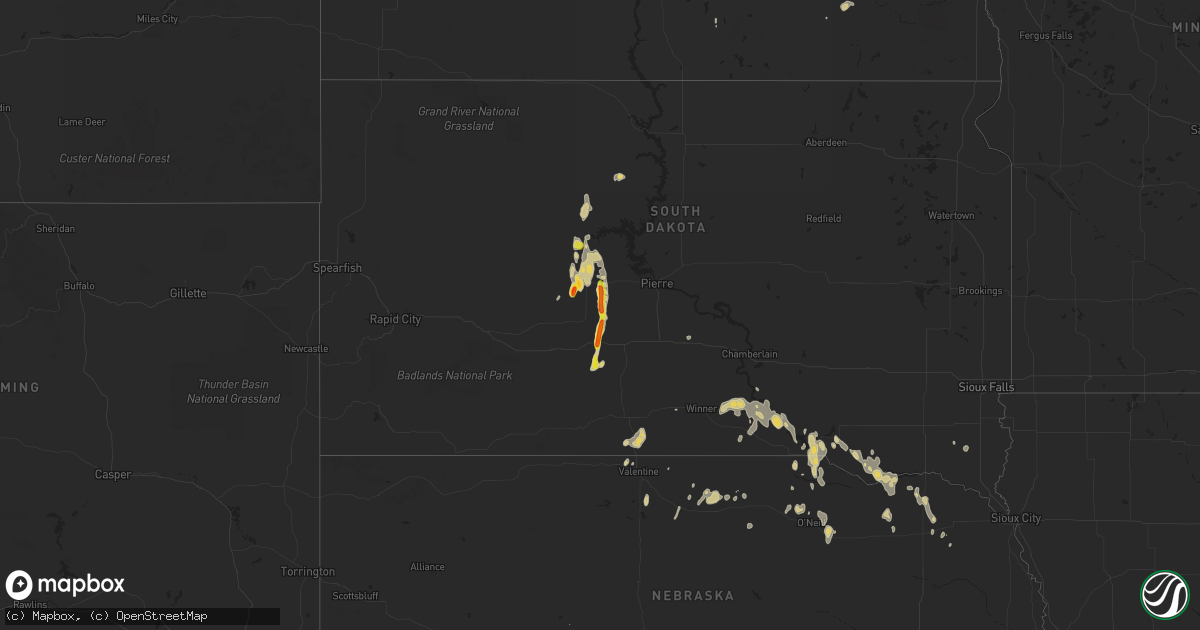
Hail Map on September 20, 2023
Get this storm
September 20 map
$229
one time, instant access
Download today. No call, no setup
Keep the $229
Bought the map and want the full workflow? Apply the entire $229 to a subscription within 7 days. None of it is wasted.
Every map, not just this one
This buys you this map. Subscription and you get every map we run, in the markets you choose from a few cities to whole states to nationwide. Plus real-time alerts the moment a storm fires.
Contact data
Name, contact info, occupancy, even credit band for addresses in the footprint. You go from where it hit to who to call.
Become the source they trust
Unlimited branding weather history reports on demand. You already have the documented answer ready for the property owner, and you are the one who showed up with it.
Property data and RoofTrace estimates
Pull up any address you have got, its value and the exact code rules for that jurisdiction, straight from One Click Code. Then RoofTrace estimates the squares, pitch, and roof value, priced the way you price.
States Impacted by Hail Map on September 20, 2023
Storm reports
Tennessee
| Date | Description |
|---|---|
| 09/20/20234:03 PM CDT | Large tree down across island dr near the island park apartment complex. |
Utah
| Date | Description |
|---|---|
| 09/19/20238:50 PM CDT | A local report indicates 60 MPH wind near 6 W Duchesne |
| 09/19/20237:30 PM CDT | A local report indicates 75 MPH wind near Knolls |
South Dakota
| Date | Description |
|---|---|
| 09/19/20238:33 PM CDT | Lots of quarter size hail... Some as big as golfballs. |
| 09/19/20237:50 PM CDT | Largest stones were quarter to ping pong size. |
| 09/19/20237:49 PM CDT | Mping report |
Florida
| Date | Description |
|---|---|
| 09/20/20235:05 PM CDT | Tempest station dorset ln reports wind gust to 58 mph from a thunderstorm. Delayed report. |
Nevada
| Date | Description |
|---|---|
| 09/20/20234:37 PM CDT | Mesonet station sevn2 seven mile raws station elevation: 7725 ft. |
Cities Impacted by Hail Map on September 20, 2023
- Tibbie, AL
- Wagarville, AL
- Leroy, AL
- Jackson, AL
- Hastings, NE
- Ellaville, GA
- North Port, FL
- Walls, MS
- Memphis, TN
- Crookston, NE
- Lake Cormorant, MS
- Hernando, MS
- Palm Harbor, FL
- Tampa, FL
- Dunedin, FL
- Okeechobee, FL
- Sarasota, FL
- Orlando, FL
- Marion, AR
- West Memphis, AR
- Bradenton, FL
- Southaven, MS
- Horn Lake, MS
- Crystal Beach, FL
- White River, SD
- Okaton, SD
- Fort Pierre, SD
- Midland, SD
- Dupree, SD
- Hayes, SD
- Mission, SD
- Valentine, NE
- Montpelier, ID
- Henderson, NV
- Las Vegas, NV
- Eagle Butte, SD
- Gregory, SD
- Dallas, SD
- Burke, SD
- Winner, SD
- Whitefield, OK
- Stigler, OK
- Marion, ND
- Johnstown, NE
- Mentor, MN
- Porum, OK
- Kennebec, SD
- Presho, SD
- Geddes, SD
- Bassett, NE
- Dante, SD
- Platte, SD
- Atkinson, NE
- Oneill, NE
- Fairfax, SD
- Lake Andes, SD
- Spencer, NE
- Bristow, NE
- Niobrara, NE
- Bloomfield, NE
- Newport, NE
- Springfield, SD
- Pickstown, SD
- Long Pine, NE
- Butte, NE
- Medina, ND
- Wagner, SD
- Avon, SD
- Page, NE
- Inman, NE
- Litchville, ND
- Ainsworth, NE
- Lynch, NE
- Tappen, ND
- Tyndall, SD
- Stuart, NE
- Crofton, NE
- Coleridge, NE
- Randolph, NE
- Hartington, NE
- Centerville, SD
- Fordyce, NE
- Creighton, NE
- Carroll, NE
- Belden, NE
- Ewing, NE
- Irene, SD
- Plainview, NE
- Wayne, NE