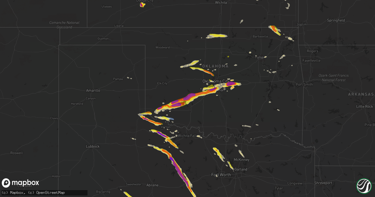
Hail Map on September 19, 2023
Get this storm
September 19 map
$229
one time, instant access
Download today. No call, no setup
Keep the $229
Bought the map and want the full workflow? Apply the entire $229 to a subscription within 7 days. None of it is wasted.
Every map, not just this one
This buys you this map. Subscription and you get every map we run, in the markets you choose from a few cities to whole states to nationwide. Plus real-time alerts the moment a storm fires.
Contact data
Name, contact info, occupancy, even credit band for addresses in the footprint. You go from where it hit to who to call.
Become the source they trust
Unlimited branding weather history reports on demand. You already have the documented answer ready for the property owner, and you are the one who showed up with it.
Property data and RoofTrace estimates
Pull up any address you have got, its value and the exact code rules for that jurisdiction, straight from One Click Code. Then RoofTrace estimates the squares, pitch, and roof value, priced the way you price.
Storm reports
Texas
| Date | Description |
|---|---|
| 09/19/20236:50 PM CDT | A local report indicates 1.00 inch wind near 4 SSE Coppers Break Sta |
| 09/19/20236:35 PM CDT | Delayed report. Live stream video showing a semi-trailer blown over on highway 287. Radar estimated time. |
| 09/19/20236:22 PM CDT | Broadcast media relays report of up to quarter size hail in the valley ranch neighborhood |
| 09/19/20236:21 PM CDT | A local report indicates 2.75 inch wind near Quanah |
| 09/19/20236:15 PM CDT | A local report indicates 68 MPH wind near 3 W Goodlett |
| 09/19/20236:12 PM CDT | Report from mping: quarter |
| 09/19/20236:05 PM CDT | Report from mping: quarter |
| 09/19/20235:55 PM CDT | 60+ mph winds reported in robson ranch. |
| 09/19/20235:38 PM CDT | A local report indicates 2.50 inch wind near 10 E Childress |
| 09/18/202311:15 PM CDT | Delayed report. Several photos from broadcast media across portions of springtown showing blown sheet metal... Damaged metal sheds... And an overturned truck trailer. |
| 09/18/202310:30 PM CDT | Delayed report. Golf ball size hail around the strawn area. |
| 09/18/202310:14 PM CDT | Delayed report. Golf ball size hail outside of caddo. |
| 09/18/20239:12 PM CDT | Golf ball sized hail was reported by the throckmorton county sheriff office. |
| 09/18/20238:34 PM CDT | Report from mping: 1-inch tree limbs broken; shingles blown off. |
| 09/18/20238:20 PM CDT | Delayed report. Social media video showing quarter to half dollar size hail. Radar estimated time. |
| 09/18/20238:11 PM CDT | A local report indicates 62 MPH wind near 5 S Electra |
| 09/18/20238:06 PM CDT | A local report indicates 1.25 inch wind near 3 E Lake Kemp |
| 09/18/20237:15 PM CDT | Corrects previous hail report from thalia. Storm likely passed well before report was relayed... Indicating some melting was likely. |
| 09/18/20237:02 PM CDT | A local report indicates 1.75 inch wind near Chillicothe |
Oklahoma
| Date | Description |
|---|---|
| 09/19/20236:55 PM CDT | A local report indicates 58 MPH wind near 4 S Tipton |
| 09/19/20236:45 PM CDT | Delayed report. Relayed image showing golf ball size hail. Radar estimated time. |
| 09/19/20236:35 PM CDT | A local report indicates 1.50 inch wind near 1 W Martha |
| 09/19/20236:15 PM CDT | Relayed report. Time estimated by radar. |
| 09/19/20231:24 PM CDT | A local report indicates 1.00 inch wind near Stillwater |
| 09/19/20235:40 AM CDT | Delayed report. Multiple large |
| 09/18/202310:05 PM CDT | Delayed report. |
| 09/18/20239:58 PM CDT | Corrects previous hail report from 2 wnw aydelotte. |
| 09/18/20239:51 PM CDT | Delayed report. Report from mping: quarter |
| 09/18/20239:45 PM CDT | A local report indicates 2.50 inch wind near 3 WSW Johnson |
| 09/18/20239:44 PM CDT | Delayed report. Report from mping: quarter |
| 09/18/20239:41 PM CDT | A local report indicates 1.00 inch wind near 2 N Shawnee |
| 09/18/20239:38 PM CDT | A local report indicates 1.75 inch wind near 4 NW Shawnee |
| 09/18/20239:36 PM CDT | A local report indicates 1.00 inch wind near 3 E Dale |
| 09/18/20239:35 PM CDT | A local report indicates 1.50 inch wind near 3 N Mcloud |
| 09/18/20239:09 PM CDT | A local report indicates 1.00 inch wind near 6 E Piedmont |
| 09/18/20239:08 PM CDT | A local report indicates 1.50 inch wind near 6 E Piedmont |
| 09/18/20239:03 PM CDT | Delayed report. Report from mping: ping pong ball |
| 09/18/20239:01 PM CDT | Delayed report. Report from mping: half dollar |
| 09/18/20239:00 PM CDT | Delayed report. Report from mping: ping pong ball |
| 09/18/20238:54 PM CDT | Delayed report. Report from mping: half dollar |
| 09/18/20238:48 PM CDT | Delayed report. Relayed image showing golf ball to hen egg size hail. |
| 09/18/20238:47 PM CDT | A local report indicates 1.00 inch wind near 3 NNE Piedmont |
| 09/18/20237:50 PM CDT | Report from mping: quarter |
| 09/18/20237:49 PM CDT | Report from mping: quarter |
| 09/18/20237:45 PM CDT | A local report indicates 1.00 inch wind near 2 NE Boone |
| 09/18/20237:25 PM CDT | Delayed report. Relayed image showing the roof of a metal barn removed. Radar estimated time. |
| 09/18/20237:15 PM CDT | A local report indicates 1.00 inch wind near 2 ESE Watonga |
| 09/18/20237:15 PM CDT | A local report indicates 74 MPH wind near 4 S Tipton |
| 09/18/20237:11 PM CDT | A local report indicates 58 MPH wind near 4 SE Hobart |
| 09/18/20237:09 PM CDT | A local report indicates 1.75 inch wind near 3 N Tom Steed Reservoir |
| 09/18/20237:08 PM CDT | A local report indicates 2.00 inch wind near 1 NNW Roosevelt |
| 09/18/20237:03 PM CDT | Report from mping: quarter |
Kansas
| Date | Description |
|---|---|
| 09/19/20236:47 PM CDT | A local report indicates 1.00 inch wind near 4 E Ensign |
| 09/19/20236:35 PM CDT | Reports of quarter sized hail near 150. |
| 09/19/20235:26 PM CDT | A local report indicates 1.00 inch wind near 6 SW Ft. Dodge |
| 09/19/20235:22 PM CDT | 3-inch tree limbs and power poles broken. |
| 09/19/20231:45 PM CDT | Asos station kgck garden city. |
| 09/18/20238:25 PM CDT | Received the report via social media. |
| 09/18/20237:10 PM CDT | A local report indicates 1.75 inch wind near 8 ESE Ensign |
| 09/18/20237:00 PM CDT | A local report indicates 2.00 inch wind near 3 E Ensign |
Florida
| Date | Description |
|---|---|
| 09/19/20236:55 PM CDT | Miami kendall-tamiami executive airport asos |
Cities Impacted by Hail Map on September 19, 2023
- Cedar Vale, KS
- Portsmouth, IA
- Panama, IA
- Nevada, IA
- Ames, IA
- Boone, IA
- Ogden, IA
- Adair, IA
- Casey, IA
- Guthrie Center, IA
- Persia, IA
- Madrid, IA
- Granger, IA
- Nash, OK
- Colo, IA
- Carroll, IA
- Grand Junction, IA
- Polk City, IA
- Maxwell, IA
- Cambridge, IA
- Elkhart, IA
- Huxley, IA
- Woodbine, IA
- Woodward, IA
- Panora, IA
- Linden, IA
- Churdan, IA
- Scranton, IA
- Toronto, KS
- Kelley, IA
- Wamego, KS
- Virgil, KS
- Fall River, KS
- Slater, IA
- Collins, IA
- State Center, IA
- Beaver, IA
- Alma, KS
- Yale, IA
- Dexter, KS
- Pond Creek, OK
- Medford, OK
- Stillwater, OK
- Deer Creek, OK
- Lamont, OK
- Nardin, OK
- Blackwell, OK
- Ponca City, OK
- Saint Jo, TX
- Forestburg, TX
- Decatur, TX
- Sanger, TX
- Rosston, TX
- Krum, TX
- Dodge City, KS
- Childress, TX
- Quanah, TX
- Exira, IA
- Jefferson, IA
- Manilla, IA
- Tonkawa, OK
- Perkins, OK
- Coyle, OK
- Moore Haven, FL
- Coon Rapids, IA
- Arcadia, IA
- Okeechobee, FL
- Atlantic, IA
- Manning, IA
- Bagley, IA
- Audubon, IA
- Lewis, IA
- Cumberland, IA
- Wiota, IA
- Clewiston, FL
- Elliott, IA
- Griswold, IA
- Massena, IA
- Red Oak, IA
- Johnston, IA
- Shelby, IA
- Harlan, IA
- Avoca, IA
- Cushing, OK
- Agra, OK
- Immokalee, FL
- Hamlin, IA
- Gainesville, TX
- Era, TX
- Vero Beach, FL
- Sebastian, FL
- Defiance, IA
- Kenansville, FL
- Eldorado, OK
- Gould, OK
- Miami, FL
- Ochopee, FL
- Lake Dallas, TX
- Denton, TX
- Lewisville, TX
- Duke, OK
- Olustee, OK
- Altus, OK
- Blair, OK
- Nekoma, KS
- Rush Center, KS
- Hitchcock, OK
- Okeene, OK
- Headrick, OK
- Mountain Park, OK
- Chillicothe, TX
- Coppell, TX
- Carrollton, TX
- Kingfisher, OK
- Roosevelt, OK
- Vernon, TX
- Elmer, OK
- Odell, TX
- Frederick, OK
- Tipton, OK
- Lawton, OK
- Mountain View, OK
- Hobart, OK
- Hanston, KS
- Crowell, TX
- Burdett, KS
- Elgin, OK
- Carnegie, OK
- Apache, OK
- Fort Cobb, OK
- Seymour, TX
- Munday, TX
- Goree, TX
- Electra, TX
- Watonga, OK
- Omega, OK
- Anadarko, OK
- Maryneal, TX
- Blackwell, TX
- Throckmorton, TX
- Verden, OK
- Chickasha, OK
- Gracemont, OK
- Amber, OK
- Pocasset, OK
- Bronte, TX
- Coffeyville, KS
- S Coffeyville, OK
- Holliday, TX
- Okarche, OK
- Minco, OK
- Tuttle, OK
- Blanchard, OK
- Newcastle, OK
- Welch, OK
- Lenapah, OK
- Newcastle, TX
- Oklahoma City, OK
- Piedmont, OK
- Edmond, OK
- Cashion, OK
- Washington, OK
- Norman, OK
- Woodson, TX
- Graham, TX
- Breckenridge, TX
- Delaware, OK
- Vinita, OK
- Mcloud, OK
- Newalla, OK
- Shawnee, OK
- Meeker, OK
- Yukon, OK
- Earlsboro, OK
- Prague, OK
- Bluejacket, OK
- Caddo, TX
- Ranger, TX
- Strawn, TX
- Mangum, OK
- Caddo, OK
- Alexander, KS
- Larned, KS
- Mustang, OK
- Union City, OK
- Guthrie, OK
- Ponder, TX
- Oakwood, OK
- Dallas, TX
- Wellston, OK
- Harrah, OK
- Iraan, TX
- Tecumseh, OK
- Bridgewater, IA
- Anita, IA
- La Crosse, KS
- Bison, KS
- Henrietta, TX
- Creston, IA
- Canton, OK
- Fay, OK
- Flower Mound, TX
- Argyle, TX
- Irving, TX
- Grapevine, TX
- Fontanelle, IA
- Glidden, IA
- Macomb, OK
- Robert Lee, TX
- Altus Afb, OK
- Snyder, OK
- Bazine, KS
- Ness City, KS
- Davidson, OK
- Irwin, IA
- Jamaica, IA
- Hennessey, OK
- Benjamin, TX
- Ringgold, TX
- Seminole, OK
- Luther, OK
- Colorado City, TX
- Choctaw, OK
- Loraine, TX
- Mingus, TX
- Desdemona, TX
- Dublin, TX
- Stephenville, TX
- Osage, OK
- Haskell, OK
- Locust Grove, OK
- Villisca, IA
- Tahlequah, OK
- Stilwell, OK
- Tulsa, OK
- Catoosa, OK
- Olney, TX
- Cimarron, KS
- Council Bluffs, IA
- Fort Worth, TX
- Pampa, TX
- Miami, TX
- Girard, KS
- Walnut, KS
- Fairland, OK
- Afton, OK
- Grove, OK
- Glenwood, IA
- Farlington, KS
- Hepler, KS
- South Bend, TX
- Van Alstyne, TX
- Muskogee, OK
- Savonburg, KS
- Uniontown, KS
- Sand Springs, OK
- Pacific Junction, IA
- Kenefic, OK
- Milburn, OK
- Coleman, OK
- Atoka, OK
- Tishomingo, OK
- Boynton, OK
- Whitesboro, TX
- Howe, TX
- Olpe, KS
- Hartford, KS
- Malvern, IA
- Okmulgee, OK
- Tabor, IA
- Thurman, IA
- Sidney, IA
- Alvord, TX
- Nashoba, OK
- Clayton, OK
- Anna, TX
- Sherman, TX
- Gunter, TX
- Celina, TX
- Porter, OK
- Mobeetie, TX
- Muenster, TX
- Randolph, IA
- Mcalester, OK
- Haileyville, OK
- Hartshorne, OK
- Collinsville, TX
- Melissa, TX
- El Reno, OK
- Hendrix, OK
- Purcell, OK
- Gordon, TX
- Blue Ridge, TX
- Farmersville, TX
- Princeton, TX
- Mckinney, TX