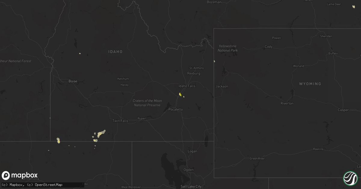
Hail Map on September 16, 2024
Get this storm
September 16 map
$229
one time, instant access
Download today. No call, no setup
Keep the $229
Bought the map and want the full workflow? Apply the entire $229 to a subscription within 7 days. None of it is wasted.
Every map, not just this one
This buys you this map. Subscription and you get every map we run, in the markets you choose from a few cities to whole states to nationwide. Plus real-time alerts the moment a storm fires.
Contact data
Name, contact info, occupancy, even credit band for addresses in the footprint. You go from where it hit to who to call.
Become the source they trust
Unlimited branding weather history reports on demand. You already have the documented answer ready for the property owner, and you are the one who showed up with it.
Property data and RoofTrace estimates
Pull up any address you have got, its value and the exact code rules for that jurisdiction, straight from One Click Code. Then RoofTrace estimates the squares, pitch, and roof value, priced the way you price.
States Impacted by Hail Map on September 16, 2024
Storm reports
Colorado
| Date | Description |
|---|---|
| 09/16/20244:17 PM CDT | Kcoflagl13. |
| 09/16/20244:00 PM CDT | Reported via social media. Estimated 50-60 mph winds. Time estimated via report. |
| 09/16/20242:56 PM CDT | Mesonet station co098 139s034 douglas pass. |
Utah
| Date | Description |
|---|---|
| 09/16/20245:50 PM CDT | Measured at the salt flats dugway site. |
| 09/16/20244:55 PM CDT | Measured at the causeway dugway mesonet site. |
| 09/16/20244:05 PM CDT | Measured at the vgrid dugway site. |
Minnesota
| Date | Description |
|---|---|
| 09/16/20244:48 PM CDT | Large tree down 6 to 8 inches in diameter. Report via social media. |
| 09/16/20248:48 AM CDT | Estimated 50 mph winds along with the hail. |
Oregon
| Date | Description |
|---|---|
| 09/15/20248:29 PM CDT | A local report indicates 64 MPH wind near 1 E Burns Junction |
Kansas
| Date | Description |
|---|---|
| 09/16/20246:42 PM CDT | Dispatch reported multiple power lines down along k lane between 1400th-1500th road. Time is radar estimated. Report called in at 6:31 pm mt. |
| 09/16/20246:42 PM CDT | Corrects previous tstm wnd dmg report from 7 nnw dresden. Dispatch reported multiple power poles... Roughly 9 poles... Down near the base along k lane between 1400th-15 |
| 09/15/202410:17 PM CDT | A personal weather station measured a 63 mph wind gust at 10:17 pm. |
| 09/15/20248:54 PM CDT | Delayed report via social media. Estimated up to ping pong ball sized hail that occurred on and off over an hour. Hail broke some vehicle windshields with some smaller |
| 09/15/20248:45 PM CDT | Facebook with pictures of multiple 2-2.25 stones. |
| 09/15/20248:25 PM CDT | Pictures on social media of minor roof damage and mention of damage to signs and poles. Time estimated via radar. |
| 09/15/20247:35 PM CDT | Spotter estimated 50-60 mph winds at the estimated report time. |
| 09/15/20247:15 PM CDT | Reported via mesonet up846. |
| 09/15/20247:03 PM CDT | Oberline7ne. |
Idaho
| Date | Description |
|---|---|
| 09/16/20246:45 PM CDT | Mesonet station mali 2 nw idahome. |
| 09/16/20246:39 PM CDT | Mesonet station mofi1 moburg canyon. |
| 09/16/20246:20 PM CDT | Mesonet station pc371 medicine lodge. |
| 09/16/20246:15 PM CDT | Time corrected. Mesonet station msi04 - pilot gold. |
| 09/16/20246:10 PM CDT | Time corrected. Mesonet station mofi1 - moburg canyon. |
| 09/16/20245:42 PM CDT | Photos of estimated half dollar size hail received from the public and relayed to nws pocatello by kifi. Hail fell near the intersection of e 350 n and hancock rd/n 100 |
| 09/15/20249:20 PM CDT | Mesonet station sum big southern butte. |
| 09/15/20248:30 PM CDT | Measured at deer haven raws. |
| 09/15/20247:45 PM CDT | Rwis itdb2 monida pass i-15. |
| 09/15/20247:00 PM CDT | Mesonet station msi04 pilot gold. |
| 09/15/20247:00 PM CDT | Rwis itd12 yale i-84. |
North Dakota
| Date | Description |
|---|---|
| 09/15/20247:35 PM CDT | Heavy rain also occurring with the hail. |
| 09/15/20247:02 PM CDT | Social media picture of tennis ball size hail south of velva earlier this evening. |
Cities Impacted by Hail Map on September 16, 2024
- Adams, ND
- Pisek, ND
- Forest River, ND
- Park River, ND
- Edinburg, ND
- Lankin, ND
- Fordville, ND
- Lebanon, KS
- Emerado, ND
- Smith Center, KS
- Grafton, ND
- Grand Forks, ND
- Minto, ND
- Mekinock, ND
- Manvel, ND
- Gaylord, KS
- Portis, KS
- Drayton, ND
- East Grand Forks, MN
- Oslo, MN
- Glen Elder, KS
- Beloit, KS
- Alvarado, MN
- Stephen, MN
- Kennedy, MN
- Argyle, MN
- Beverly, KS
- Warren, MN
- Viking, MN
- Strandquist, MN
- Karlstad, MN
- Donaldson, MN
- Lancaster, MN
- Badger, MN
- Lake Bronson, MN
- Newfolden, MN
- Greenbush, MN
- Strathcona, MN
- Sylvan Grove, KS
- Lincoln, KS
- Ashton, NE
- Southport, NC
- Bolivia, NC
- Williams, MN
- Milton, ND
- Winnabow, NC
- Langdon, ND
- Munich, ND
- Alsen, ND
- Wales, ND
- Monticello, UT
- Leeds, ND
- Churchs Ferry, ND
- Towaoc, CO
- Cando, ND
- Mooreland, OK
- Walhalla, ND
- Otter, MT
- Ryder, ND
- Euclid, MN
- Hampden, ND
- Cascade, ID
- Blackfoot, ID
- Osnabrock, ND
- Douglas, ND
- Rogerson, ID
- Pompano Beach, FL
- Bruneau, ID
- Deerfield Beach, FL
- Coral Springs, FL
- Max, ND
- Minot, ND
- Boca Raton, FL
- Sawyer, ND
- Selden, KS
- Norwich, ND
- Mountain, ND
- Oberlin, KS
- Velva, ND
- Danbury, NE
- Lebanon, NE
- Norcatur, KS
- Cavalier, ND
- Voltaire, ND
- Surrey, ND
- Laverne, OK
- Quinter, KS
- Collyer, KS
- Park, KS
- Granville, ND
- Wakeeney, KS
- Morland, KS
- Karlsruhe, ND
- May, OK
- Hoxie, KS
- Balfour, ND
- Penokee, KS
- Towner, ND
- Butte, ND
- Durango, CO
- Ignacio, CO
- Pembina, ND
- Saint Vincent, MN
- Drake, ND
- Anamoose, ND
- Rugby, ND
- Hill City, KS
- Gove, KS
- Mcclusky, ND
- Broken Bow, NE
- Strasburg, ND
- Linton, ND
- Wing, ND
- Ellis, KS
- Anselmo, NE
- Ideal, SD
- Presho, SD
- Edison, NE
- Selby, SD
- Merna, NE
- Agar, SD
- Springview, NE
- Johnstown, NE
- Witten, SD
- Pierre, SD
- Winner, SD
- Sterling, ND
- Pollock, SD
- Herreid, SD
- Beaver City, NE
- Onida, SD
- Lenora, KS
- Bogue, KS
- Callaway, NE
- Ainsworth, NE
- Fort Pierre, SD
- Moffit, ND
- Brewster, NE
- Hazelton, ND
- Glenham, SD
- Almena, KS
- Oconto, NE
- Gettysburg, SD
- Lexington, NE
- Elwood, NE
- Regan, ND
- Norton, KS
- Arapahoe, NE
- Hendley, NE
- Cozad, NE
- Eustis, NE
- Purdum, NE
- Arnold, NE
- Utica, KS
- Knox, ND
- York, ND
- Esmond, ND
- Maddock, ND
- Ingalls, KS
- Copeland, KS
- Sublette, KS
- Pierceville, KS
- Montezuma, KS
- Cimarron, KS
- Minnewaukan, ND
- Bazine, KS
- Ness City, KS
- Beeler, KS
- Nekoma, ND
- Ransom, KS
- Neche, ND
- Jetmore, KS
- Hanston, KS
- Madison, SD
- Larned, KS
- Rush Center, KS
- Chalmers, IN
- Firth, ID
- Swansboro, NC
- Newport, NC