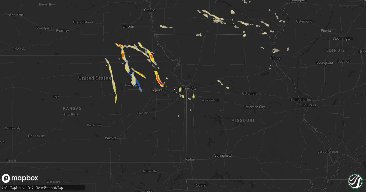
Hail Map on September 16, 2023
Get this storm
September 16 map
$229
one time, instant access
Download today. No call, no setup
Keep the $229
Bought the map and want the full workflow? Apply the entire $229 to a subscription within 7 days. None of it is wasted.
Every map, not just this one
This buys you this map. Subscription and you get every map we run, in the markets you choose from a few cities to whole states to nationwide. Plus real-time alerts the moment a storm fires.
Contact data
Name, contact info, occupancy, even credit band for addresses in the footprint. You go from where it hit to who to call.
Become the source they trust
Unlimited branding weather history reports on demand. You already have the documented answer ready for the property owner, and you are the one who showed up with it.
Property data and RoofTrace estimates
Pull up any address you have got, its value and the exact code rules for that jurisdiction, straight from One Click Code. Then RoofTrace estimates the squares, pitch, and roof value, priced the way you price.
States Impacted by Hail Map on September 16, 2023
Storm reports
Kansas
| Date | Description |
|---|---|
| 09/16/20235:35 PM CDT | A local report indicates 1.00 inch wind near 1 SSE Lackmans |
| 09/16/20235:35 PM CDT | A local report indicates 1.00 inch wind near 4 WSW Stanley |
| 09/16/20235:16 PM CDT | Pea to nickel size hail. Time estimated radar. |
| 09/16/20235:09 PM CDT | K-92 highway and valley view drive. |
| 09/16/20235:08 PM CDT | Significant damage caused to vehicles and windows relayed by the em. Delayed report... Time estimated radar. |
| 09/16/20235:08 PM CDT | A local report indicates 2.00 inch wind near 3 W Ozawkie |
| 09/16/20235:05 PM CDT | A local report indicates 1.00 inch wind near 5 E Olsburg |
| 09/16/20235:05 PM CDT | A local report indicates 60 MPH wind near 5 E Olsburg |
| 09/16/20234:38 PM CDT | Photos shared. Radar estimated time. |
| 09/16/20234:35 PM CDT | A local report indicates 70 MPH wind near 1 S Waterville |
| 09/16/20234:25 PM CDT | A local report indicates 1.00 inch wind near 6 N Holton |
| 09/16/20234:17 PM CDT | Nickel size hail also reported by county em. |
| 09/16/20233:58 PM CDT | Small... 1 inch limbs down. Lots of pea to nickel size hail as well. |
| 09/16/20233:38 PM CDT | A local report indicates 1.25 inch wind near 6 N Hanover |
| 09/16/20233:15 PM CDT | Hail covering the ground. |
| 09/16/20232:50 PM CDT | A local report indicates 1.75 inch wind near 5 ENE Bern |
| 09/15/20238:25 PM CDT | A local report indicates 1.00 inch wind near 1 N Tampa |
| 09/15/20237:56 PM CDT | Social media photo. |
| 09/15/20237:40 PM CDT | A local report indicates 1.00 inch wind near 6 SSW Enterprise |
| 09/15/20237:40 PM CDT | A local report indicates 1.00 inch wind near 6 S Enterprise |
| 09/15/20237:20 PM CDT | Most were around quarter size. |
| 09/15/20237:10 PM CDT | A local report indicates 1.00 inch wind near 5 NE Talmage |
| 09/15/20237:06 PM CDT | Radar estimated time. |
Texas
| Date | Description |
|---|---|
| 09/16/20234:19 PM CDT | The asos station at the valley international airport in harlingen gusted to 74 mph at 4:19pm cdt. |
| 09/16/20234:08 PM CDT | The asos at harlingen airport gusted to 71 mph at 4:08pm cdt. |
| 09/16/20238:15 AM CDT | A local report indicates 74 MPH wind near 3 WNW Doole |
Nebraska
| Date | Description |
|---|---|
| 09/16/20233:32 PM CDT | A local report indicates 1.00 inch wind near Diller |
| 09/16/20232:35 PM CDT | Corrected magnitude to properly reflect size of golf ball sized hail. Quarter to golf ball sized hail. |
Cities Impacted by Hail Map on September 16, 2023
- Ballinger, TX
- Bronte, TX
- Winters, TX
- Norton, TX
- Miles, TX
- San Angelo, TX
- Goodfellow Afb, TX
- Rowena, TX
- Christoval, TX
- Vancourt, TX
- Paint Rock, TX
- Millersview, TX
- Voss, TX
- Eden, TX
- Lohn, TX
- Doole, TX
- Gouldbusk, TX
- Rockwood, TX
- Rochelle, TX
- Melvin, TX
- Brady, TX
- Richland Springs, TX
- San Saba, TX
- Early, TX
- Blanket, TX
- Zephyr, TX
- Mullin, TX
- Goldthwaite, TX
- Brownwood, TX
- Lampasas, TX
- Imogene, IA
- Shenandoah, IA
- Farragut, IA
- Randolph, IA
- Winterset, IA
- Lometa, TX
- Bend, TX
- Kempner, TX
- Briggs, TX
- Essex, IA
- Clarinda, IA
- Coleman, TX
- Tecumseh, NE
- Elk Creek, NE
- Humboldt, NE
- Steinauer, NE
- Plymouth, NE
- Jansen, NE
- Beatrice, NE
- Dawson, NE
- Sabetha, KS
- Fairview, KS
- Diller, NE
- Odell, NE
- Steele City, NE
- Hollenberg, KS
- Hanover, KS
- Waterville, KS
- Agenda, KS
- Clyde, KS
- Clifton, KS
- Netawaka, KS
- Holton, KS
- Whiting, KS
- Denison, KS
- Mayetta, KS
- Bremen, KS
- Blue Rapids, KS
- Randolph, KS
- Olsburg, KS
- Hoyt, KS
- Meriden, KS
- Valley Falls, KS
- Kansas City, KS
- Bonner Springs, KS
- Ozawkie, KS
- Lees Summit, MO
- Westmoreland, KS
- Saint George, KS
- Wamego, KS
- Manhattan, KS
- Overland Park, KS
- Olathe, KS
- Greenwood, MO
- Alma, KS
- Paxico, KS
- McFarland, KS
- Ursa, IL
- Bussey, IA
- Albia, IA
- Chariton, IA
- Caledonia, MN
- Wetmore, KS
- Ainsworth, IA
- Washington, IA
- Bloomfield, IA
- Daykin, NE
- Washington, KS
- Virginia, NE
- Brownsville, MN
- Montezuma, IA
- Searsboro, IA
- New Sharon, IA
- Monroe City, MO
- Hannibal, MO
- Winfield, IA
- Murray, IA
- Osceola, IA
- Carrollton, MO
- Peru, IA
- Truro, IA
- Yarmouth, IA
- Mount Union, IA
- Keswick, IA
- Oneida, KS
- Seneca, KS
- Bangor, WI
- Westby, WI
- Coon Valley, WI
- Rockland, WI
- Cashton, WI
- Derby, IA
- Bern, KS
- Marshall, MO
- Cordova, IL
- Camanche, IA
- Princeton, IA
- De Witt, IA
- Blakesburg, IA
- Downing, MO
- Lancaster, MO
- Manor, TX
- Elgin, TX
- Nortonville, KS
- Winchester, KS
- Barnes, KS
- Marysville, KS
- Lucas, IA
- Woodburn, IA
- Salem, IA
- Hillsboro, IA
- Knoxville, IA
- Hamilton, IA
- Lewiston, NE
- Burchard, NE
- Fairfield, IA
- New Virginia, IA
- Mendon, IL
- Farmington, IA
- Kahoka, MO
- Ottumwa, IA
- Drakesville, IA
- Unionville, IA
- Du Bois, NE
- Pawnee City, NE
- Oskaloosa, KS
- Elkader, IA
- Cuba, KS
- Belleville, KS
- San Perlita, TX
- Raymondville, TX
- Douds, IA
- Morganville, KS
- Clay Center, KS
- Burlington, IA
- Sperry, IA
- Saint Charles, IA
- Mount Sterling, IA
- Bonaparte, IA
- Harlingen, TX
- Powhattan, KS
- Table Rock, NE
- Kansas City, MO
- Tracy, IA
- Lovilia, IA
- Palmyra, MO
- Lorimor, IA
- McGregor, IA
- Garnavillo, IA
- Stockport, IA
- Russell, IA
- Birmingham, IA
- Houston, MN
- West Point, IA
- Coatsville, MO
- Malta Bend, MO
- Moulton, IA
- Centerville, IA
- Udell, IA
- Moravia, IA
- Grant City, MO
- Mount Ayr, IA
- Hatfield, MO
- Munden, KS
- Macksburg, IA
- Barnes City, IA
- Donnellson, IA
- Luray, MO
- Horton, KS
- Sebastian, TX
- Lyford, TX
- Corydon, IA
- Humeston, IA
- Weldon, IA
- Sutter, IL
- Warsaw, IL
- Greensboro, AL
- Gallion, AL
- La Belle, MO
- La Prairie, IL
- Augusta, IL
- Slater, MO
- Oketo, KS
- Grandview, MO
- Belton, MO
- Crab Orchard, NE
- Filley, NE
- Longford, KS
- Abilene, KS
- Onaga, KS
- Vermillion, KS
- Axtell, KS
- Havensville, KS
- Centralia, KS
- Enterprise, KS
- Hope, KS
- Glen Haven, WI
- Guttenberg, IA
- New Vienna, IA
- Holy Cross, IA
- Kellerton, IA
- Sandia, TX
- Mathis, TX
- Selma, IA
- Floris, IA
- Rock City, IL
- Davis, IL
- Bagley, WI
- Epworth, IA
- Farley, IA
- Frankfort, KS
- Morning Sun, IA
- Robstown, TX
- Raymore, MO
- Shawnee, KS
- Stilwell, KS
- Drexel, MO
- Keosauqua, IA
- Archie, MO
- Pecatonica, IL
- Cassville, WI
- Garber, IA
- Pleasant Hill, MO
- De Soto, KS
- Freeport, IL
- Salem, NE
- Linwood, KS
- Tonganoxie, KS
- Perry, KS
- Dakota, IL
- Ridott, IL
- Low Moor, IA
- Clinton, IA
- Fontana, KS
- La Cygne, KS
- Wakefield, KS
- Durand, IL
- Farmersburg, IA
- Pearl City, IL
- Parker, KS
- New London, IA
- Lincoln, MO
- What Cheer, IA
- Dyersville, IA
- Melrose, IA
- Paola, KS
- Foster, MO
- Cherokee, TX
- Lenexa, KS
- Comanche, TX
- Tampa, KS