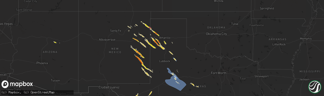
Hail Map on September 15, 2023
The weather event on September 15, 2023 includes Wind and Hail maps. 6 states and 136 cities were impacted and suffered possible damage. The total estimated number of properties impacted is 1,184.
Want more than just the map?
Turn this storm into a full workflow.
- Owner + property data so you know who to knock
- OnDemand branded weather history reports to win the "did we even have hail?" argument
- RoofTrace estimate so reps stop guessing numbers at the door
Bought this map? Upgrade within 7 days and we'll credit the $230. (10-15 min setup call)
Wind
Hail
1,184
Estimated number of impacted properties by a 1.00" hail or larger199
Estimated number of impacted properties by a 1.75" hail or larger7
Estimated number of impacted properties by a 2.50" hail or largerStates Impacted by Hail Map on September 15, 2023
Storm reports
Texas
| Date | Description |
|---|---|
| 09/15/20234:35 PM CDT | Large tree knocked down on road and parked car. Time estimated based on radar. |
| 09/15/20235:43 AM CDT | Corrects previous tstm wnd gst report from 2 ese colorado city. Mesonet station ur103 2.2 e colorado city |
| 09/15/20235:28 AM CDT | Mesonet station ur103 2.2 e colorado city |
| 09/15/20235:14 AM CDT | Mesonet station 105 5nw colorado city. |
| 09/15/20235:12 AM CDT | Mesonet station 77 1sse lomax lomax/howard county. |
| 09/15/20233:58 AM CDT | Mesonet station 26 gail 2se. |
| 09/15/20233:29 AM CDT | A local report indicates 59 MPH wind near 5 SSW Graham |
| 09/15/20231:24 AM CDT | A local report indicates 90 MPH wind near 3 NNW McAdoo |
| 09/14/20239:35 PM CDT | A local report indicates 66 MPH wind near 5 ENE Hereford |
Cities Impacted by Hail Map on September 15, 2023
- Humble, TX
- Houston, TX
- Channelview, TX
- Clayton, NM
- Amistad, NM
- Nara Visa, NM
- Cuervo, NM
- Newkirk, NM
- Alpine, TX
- Fort Stockton, TX
- Fort Davis, TX
- Missouri City, TX
- Spring, TX
- Marathon, TX
- Stockdale, TX
- Vega, TX
- Tucumcari, NM
- Skidmore, TX
- Hereford, TX
- Dimmitt, TX
- Canyon, TX
- Happy, TX
- Nazareth, TX
- Tulia, TX
- Roswell, NM
- Broadview, NM
- Friona, TX
- Bovina, TX
- Fort Sumner, NM
- Roy, NM
- Sedona, AZ
- Comstock, TX
- Van Horn, TX
- Mills, NM
- Worthington, MN
- Brewster, MN
- Yorktown, TX
- Goliad, TX
- Laredo, TX
- Coyanosa, TX
- Grandfalls, TX
- Dryden, TX
- Beeville, TX
- Ocate, NM
- Kenedy, TX
- Garita, NM
- Conchas Dam, NM
- Wagon Mound, NM
- Encinal, TX
- Gillett, TX
- Ecleto, TX
- Dalhart, TX
- Channing, TX
- Alice, TX
- Mosquero, NM
- Tilden, TX
- Rock Valley, IA
- Nordheim, TX
- Runge, TX
- Sioux Center, IA
- Taiban, NM
- Elida, NM
- Tatum, NM
- Lovington, NM
- Crosbyton, TX
- Mcadoo, TX
- Dickens, TX
- Realitos, TX
- Claude, TX
- San Ygnacio, TX
- Leakey, TX
- Mcalister, NM
- Melrose, NM
- Clovis, NM
- Grady, NM
- San Jon, NM
- Texico, NM
- Hebbronville, TX
- Santa Rosa, NM
- Yeso, NM
- Seminole, TX
- Kress, TX
- Uvalde, TX
- Lockney, TX
- Freer, TX
- Floydada, TX
- Odonnell, TX
- Tahoka, TX
- Post, TX
- Gail, TX
- Fluvanna, TX
- Ira, TX
- Snyder, TX
- Coahoma, TX
- Westbrook, TX
- Big Spring, TX
- Colorado City, TX
- Garden City, TX
- Sterling City, TX
- Loraine, TX
- Hermleigh, TX
- Stanton, TX
- Knott, TX
- Roscoe, TX
- Maryneal, TX
- Blackwell, TX
- Robert Lee, TX
- Carlsbad, TX
- San Angelo, TX
- Bronte, TX
- Wingate, TX
- Winters, TX
- Ballinger, TX
- Norton, TX
- Miles, TX
- Andrews, TX
- Coleman, TX
- Dilley, TX
- Brownwood, TX
- Alvord, IA
- Rock Rapids, IA
- Hull, IA
- Doon, IA
- Monument, NM
- Hobbs, NM
- Irene, SD
- Volin, SD
- Burbank, SD
- Elk Point, SD
- Denver City, TX
- Vanderpool, TX
- Sonora, TX
- Wakonda, SD
- Bangs, TX
- Santa Anna, TX
- Novice, TX