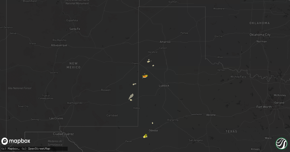
Hail Map on September 14, 2022
Get this storm
September 14 map
$229
one time, instant access
Download today. No call, no setup
Keep the $229
Bought the map and want the full workflow? Apply the entire $229 to a subscription within 7 days. None of it is wasted.
Every map, not just this one
This buys you this map. Subscription and you get every map we run, in the markets you choose from a few cities to whole states to nationwide. Plus real-time alerts the moment a storm fires.
Contact data
Name, contact info, occupancy, even credit band for addresses in the footprint. You go from where it hit to who to call.
Become the source they trust
Unlimited branding weather history reports on demand. You already have the documented answer ready for the property owner, and you are the one who showed up with it.
Property data and RoofTrace estimates
Pull up any address you have got, its value and the exact code rules for that jurisdiction, straight from One Click Code. Then RoofTrace estimates the squares, pitch, and roof value, priced the way you price.
States Impacted by Hail Map on September 14, 2022
Storm reports
Nevada
| Date | Description |
|---|---|
| 09/13/202210:25 PM CDT | At 324 PM PDT, a severe thunderstorm was located 10 miles north of Grass Valley, moving north at 10 mph. HAZARD...Ping pong ball size hail and 60 mph wind gusts. SOURCE...Radar indicated. IMPACT...People and animals outdoors will be injured. Expect hail damage to roofs, siding, windows, and vehicles. Expect wind damage to roofs, siding, and trees. Locations impacted include... Mount Tenabo. |
| 09/13/20228:39 PM CDT | At 139 PM PDT, a severe thunderstorm was located 29 miles west of Grass Valley, moving northeast at 15 mph. HAZARD...60 mph wind gusts and quarter size hail. SOURCE...Radar indicated. IMPACT...Hail damage to vehicles is expected. Expect wind damage to roofs, siding, and trees. Locations impacted include... Antelope Valley. |
Texas
| Date | Description |
|---|---|
| 09/14/20225:05 PM CDT | Coyanosa mesonet measured a 60mph wind gust at 5:05pm cdt. |
| 09/14/20224:07 PM CDT | Kent mesonet measured a thunderstorm wind gust of 63 mph at 4:07pm cdt. |
| 09/14/20221:57 AM CDT | At 656 PM CDT, a severe thunderstorm was located 14 miles south of Marathon, or 32 miles southeast of Alpine, moving south at 15 mph. HAZARD...60 mph wind gusts and penny size hail. SOURCE...Radar indicated. IMPACT...Expect damage to roofs, siding, and trees. Locations impacted include... Santiago Peak and Elephant Mountain Wildlife Management Area. |
| 09/14/20221:09 AM CDT | At 608 PM CDT, a severe thunderstorm was located 7 miles east of Monahans, moving northwest at 5 mph. HAZARD...60 mph wind gusts and penny size hail. SOURCE...Radar indicated. IMPACT...Expect damage to roofs, siding, and trees. Locations impacted include... Monahans and Monahans Sandhills State Park. This includes Interstate 20 between mile markers 83 and 93. |
South Dakota
| Date | Description |
|---|---|
| 09/14/20221:26 AM CDT | Mesonet station 55 summit |
| 09/14/20221:06 AM CDT | A local report indicates 66 MPH wind near 1 NE MIDLAND |