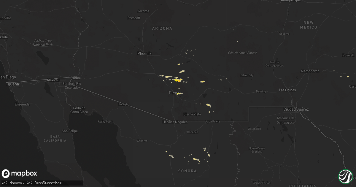
Hail Map on September 12, 2016
Get this storm
September 12 map
$229
one time, instant access
Download today. No call, no setup
Keep the $229
Bought the map and want the full workflow? Apply the entire $229 to a subscription within 7 days. None of it is wasted.
Every map, not just this one
This buys you this map. Subscription and you get every map we run, in the markets you choose from a few cities to whole states to nationwide. Plus real-time alerts the moment a storm fires.
Contact data
Name, contact info, occupancy, even credit band for addresses in the footprint. You go from where it hit to who to call.
Become the source they trust
Unlimited branding weather history reports on demand. You already have the documented answer ready for the property owner, and you are the one who showed up with it.
Property data and RoofTrace estimates
Pull up any address you have got, its value and the exact code rules for that jurisdiction, straight from One Click Code. Then RoofTrace estimates the squares, pitch, and roof value, priced the way you price.
States Impacted by Hail Map on September 12, 2016
Storm reports
Kansas
| Date | Description |
|---|---|
| 09/12/20162:30 AM CDT | A local report indicates 1.00 inch wind near 3 ESE OAKLEY |
| 09/12/20162:25 AM CDT | A local report indicates 1.00 inch wind near 3 ESE OAKLEY |
Texas
| Date | Description |
|---|---|
| 09/12/20166:58 PM CDT | A local report indicates 59 MPH wind near DRYDEN |
South Carolina
| Date | Description |
|---|---|
| 09/12/20163:18 PM CDT | Sc highway patrol reports a tree in roadway on davega road near us 378 and on hebron drive near us 378. Time estimated based on radar. |
Idaho
| Date | Description |
|---|---|
| 09/12/20164:40 PM CDT | A local report indicates 61 MPH wind near 4 W MONTPELIER |
Alabama
| Date | Description |
|---|---|
| 09/12/20163:41 PM CDT | Two trees down off highway 231 near pinckard |
| 09/12/20163:32 PM CDT | A powerline down. |
Georgia
| Date | Description |
|---|---|
| 09/12/20166:32 PM CDT | A local report indicates 1.00 inch wind near 1 W WAX |
| 09/12/20164:30 PM CDT | Around a dozen trees down at the intersection of bloomfield road and reynolds drive. A few trees were also down on homes. |
| 09/12/20162:45 PM CDT | A limb fell on a powerline that closed the intersection of klondike rd sw and mcdaniel mill rd sw. |
| 09/12/20162:15 PM CDT | Powerline down at the fredonia church along brent road. |
| 09/11/20167:55 PM CDT | A few small trees were downed along highway 52 by the gilmer-dawson county border. |
| 09/11/20167:55 PM CDT | Tree fell on home. No injuries. Via walb on twitter. |
Arizona
| Date | Description |
|---|---|
| 09/12/20164:07 PM CDT | A local report indicates 1.00 inch wind near 2 E DAVIS-MONTHAN AIR F |
| 09/11/20167:25 PM CDT | Large tree down on mobile home. |
| 09/11/20167:17 PM CDT | A local report indicates 1.75 inch wind near ORACLE |
Nebraska
| Date | Description |
|---|---|
| 09/11/20169:47 PM CDT | Report via social media. Hail up to the size of golf balls and heavy rain in york. |
| 09/11/20169:44 PM CDT | Trained spotter reports hail up to the size of quarters one and one half miles west of york. |
| 09/11/20169:42 PM CDT | Trained spotter reports hail up to the size of quarters. |
Colorado
| Date | Description |
|---|---|
| 09/12/20164:30 PM CDT | Gusts to 60 mph. |
New Mexico
| Date | Description |
|---|---|
| 09/12/20166:03 PM CDT | Kcqc asos. |
Florida
| Date | Description |
|---|---|
| 09/12/20162:25 PM CDT | One tree down on highway 81 near ponce de leon. |
| 09/12/20161:54 PM CDT | Spotter reported three trees downed along with large limbs and powerlines. Timing estimated by radar. |
| 09/12/20161:42 PM CDT | Emergency manager reported a few trees downed between ocala and belleview. Timing estimated by radar. |
Cities Impacted by Hail Map on September 12, 2016
- Postville, IA
- Luana, IA
- San Manuel, AZ
- Pecos, TX
- Greenleaf, WI
- Bear Creek, WI
- Monona, IA
- Clermont, IA
- Hope, KS
- Abilene, KS
- Jack, AL
- Oracle, AZ
- McGregor, IA
- Fort Stockton, TX
- Dryden, TX
- Humboldt, IA
- Portage, WI
- White City, KS
- Leoti, KS
- Pierre Part, LA
- Council Grove, KS
- Wilsey, KS
- Americus, KS
- Emporia, KS
- Hampton, NE
- Aurora, NE
- Calmar, IA
- Fort Atkinson, IA
- Leonardville, KS
- Randolph, KS
- Green, KS
- Lone Rock, WI
- Hartford, AL
- Daleville, AL
- Newton, AL
- Neenah, WI
- Oshkosh, WI
- Stockbridge, WI
- Chilton, WI
- Hilbert, WI
- New Hampton, IA
- De Pere, WI
- Marienthal, KS
- Herington, KS
- Barnesville, GA
- Grinnell, KS
- Elfrida, AZ
- Winkelman, AZ
- Scott City, KS
- Florence, AZ
- Deerfield, KS
- Brewton, AL
- Castleberry, AL
- Reedsburg, WI
- York, NE
- Hugoton, KS
- Prairie Du Chien, WI
- Wauzeka, WI
- Marathon, TX
- Willcox, AZ
- Waupaca, WI
- Amherst, WI
- Blue River, WI
- Bradgate, IA
- Shullsburg, WI
- Forest City, IA
- Andalusia, AL
- Ossian, IA
- Henderson, NE
- Tucson, AZ
- New Brockton, AL
- Elba, AL
- New London, WI
- Hortonville, WI
- Kaukauna, WI
- Wrightstown, WI
- McNeal, AZ
- Rockwell, IA
- Rockford, IA
- Strong City, KS
- Bradshaw, NE
- Doerun, GA
- Somers, IA
- Pittsville, WI
- Prairie Du Sac, WI
- Baraboo, WI
- Mount Horeb, WI
- Vesper, WI
- Brillion, WI
- Forest Junction, WI
- Chetek, WI
- Greene, IA
- Marble Rock, IA
- Charles City, IA
- Sylvester, GA
- Hoxie, KS
- Oakley, KS
- Ailey, GA
- Vidalia, GA
- Tarrytown, GA
- Marquette, KS
- Elroy, WI
- West Union, IA
- Weyauwega, WI
- Maple Hill, KS
- Topeka, KS
- Kewaunee, WI
- Denmark, WI
- Mishicot, WI
- Troy, AL
- Neillsville, WI
- Britt, IA
- Merrillan, WI
- Black River Falls, WI
- Mcdonough, GA
- Stockbridge, GA
- Pearce, AZ
- Norcatur, KS
- Blountstown, FL
- Bristol, FL
- Superior, NE
- Ogdensburg, WI
- Rolfe, IA
- Hurtsboro, AL
- Ellaville, GA
- Lawler, IA
- New Lisbon, WI
- Spring Green, WI
- Plain, WI
- Stromsburg, NE
- Clarks, NE
- Polk, NE
- Birmingham, AL
- Darlington, WI
- Blooming Prairie, MN
- Ellendale, MN
- Albert Lea, MN
- Clarks Grove, MN
- Hollandale, MN
- Neshkoro, WI
- Earling, IA
- Poynette, WI
- Galena, IL
- Scales Mound, IL
- Campbellsport, WI
- Kewaskum, WI
- Nora Springs, IA
- Mason City, IA
- Fairhope, AL
- Arlington, WI
- Wautoma, WI
- Hanover, KS
- Emmons, MN
- Dunlap, IA
- Thomaston, GA
- Richland Center, WI
- Luxemburg, WI
- Green Bay, WI
- Fremont, WI
- Rio, WI
- Oberlin, KS
- Solomon, KS
- Garrison, IA
- Vinton, IA
- Sherwood, WI
- Menasha, WI
- Sac City, IA
- Plaquemine, LA
- Waco, NE
- Manawa, WI
- Forsyth, GA
- Milner, GA
- Muscoda, WI
- Tribune, KS
- Rossville, KS
- Moss Point, MS
- Belmont, WI
- Gautier, MS
- Boscobel, WI
- Hordville, NE
- Oxford, WI
- Johnsonville, SC
- Castalia, IA
- Eloy, AZ
- Blue Rapids, KS
- Waunakee, WI
- Madison, WI
- Paxico, KS
- Pocahontas, IA
- Moorland, IA
- Olpe, KS
- Endeavor, WI
- Montello, WI
- Marquette, NE
- Gilmore City, IA
- Rutland, IA
- Berlin, WI
- Redgranite, WI
- Enterprise, KS
- Clarksville, FL
- Silver Creek, GA
- Aragon, GA
- Sauk City, WI
- Thompson, IA
- Leland, IA
- Linn, KS
- Bagley, WI
- Giltner, NE
- Atmore, AL
- Lake Mills, IA
- Dorrance, KS
- Bunker Hill, KS
- Ionia, IA
- Alta Vista, IA
- Crestview, FL