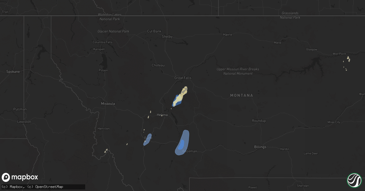
Hail Map on September 11, 2024
Get this storm
September 11 map
$229
one time, instant access
Download today. No call, no setup
Keep the $229
Bought the map and want the full workflow? Apply the entire $229 to a subscription within 7 days. None of it is wasted.
Every map, not just this one
This buys you this map. Subscription and you get every map we run, in the markets you choose from a few cities to whole states to nationwide. Plus real-time alerts the moment a storm fires.
Contact data
Name, contact info, occupancy, even credit band for addresses in the footprint. You go from where it hit to who to call.
Become the source they trust
Unlimited branding weather history reports on demand. You already have the documented answer ready for the property owner, and you are the one who showed up with it.
Property data and RoofTrace estimates
Pull up any address you have got, its value and the exact code rules for that jurisdiction, straight from One Click Code. Then RoofTrace estimates the squares, pitch, and roof value, priced the way you price.
States Impacted by Hail Map on September 11, 2024
Storm reports
Idaho
| Date | Description |
|---|---|
| 09/11/20246:00 PM CDT | Upper vienna vinmt at 9600 feet. Temp was 35 degrees. |
| 09/10/20247:36 PM CDT | Mesonet station smyi1 salmon. A strong cold front initiated a thunderstorm over the mountains to the west. Radar imagery revealed the thunderstorm dropped its core by 6 |
Florida
| Date | Description |
|---|---|
| 09/11/20246:10 AM CDT | Dispatch reported a tree down and lawn debris blown onto the road. |
Montana
| Date | Description |
|---|---|
| 09/11/20246:51 PM CDT | Personal weather station. Appears to be localized. |
| 09/11/20246:30 PM CDT | Macdonald pass mdt sensor. |
| 09/11/20245:50 PM CDT | Asos station kbtm butte-mooney ap. |
| 09/11/20244:09 PM CDT | Mesonet station tepm8 tepee pt. Radar estimate time is around 2:47 pm mdt. |
| 09/10/20248:45 PM CDT | Road closed due to trees and power lines down. |
| 09/10/20248:30 PM CDT | Tree and power lines down across road via social media. Time and location estimated. |
| 09/10/20248:25 PM CDT | Damage limited to tree limbs. |
| 09/10/20248:23 PM CDT | Asos station kbzn bozeman yellowstone airport. Also reported blowing dust. |
| 09/10/20248:00 PM CDT | Mesonet station yctim yellowstone club - avalanche. |
Wyoming
| Date | Description |
|---|---|
| 09/11/202412:53 AM CDT | Asos station klnd lander airport. |
| 09/10/20248:51 PM CDT | A local report indicates 59 MPH wind near 1 NE Echeta |
| 09/10/20247:36 PM CDT | A local report indicates 62 MPH wind near 16 WSW Dwtn Gillette |
Cities Impacted by Hail Map on September 11, 2024
- Theriot, LA
- Dulac, LA
- Pine Ridge, SD
- Patterson, LA
- Houma, LA
- Gibson, LA
- Berwick, LA
- Chauvin, LA
- Murphy, ID
- Franklin, LA
- Morgan City, LA
- Montegut, LA
- Bourg, LA
- Schriever, LA
- Gray, LA
- Thibodaux, LA
- Donner, LA
- Lockport, LA
- Raceland, LA
- Larose, LA
- Mud Butte, SD
- Faith, SD
- Baldwin, LA
- Jeanerette, LA
- Napoleonville, LA
- Labadieville, LA
- Pierre Part, LA
- Golden Meadow, LA
- Grand Isle, LA
- Galliano, LA
- Cut Off, LA
- Idaho Falls, ID
- Iona, ID
- Saint Martinville, LA
- Mathews, LA
- Des Allemands, LA
- Gheens, LA
- Donaldsonville, LA
- Plaquemine, LA
- Plattenville, LA
- Belle Rose, LA
- White Castle, LA
- Saint James, LA
- Convent, LA
- Vacherie, LA
- Edgard, LA
- Ama, LA
- Darrow, LA
- Gramercy, LA
- Lutcher, LA
- Luling, LA
- Paradis, LA
- Boutte, LA
- Hahnville, LA
- Paulina, LA
- Ririe, ID
- Island Park, ID
- Felt, ID
- Geismar, LA
- Prairieville, LA
- Gonzales, LA
- Mount Airy, LA
- Reserve, LA
- Baton Rouge, LA
- La Place, LA
- Carville, LA
- Sunshine, LA
- Garyville, LA
- Saint Amant, LA
- Addis, LA
- Saint Gabriel, LA
- Sorrento, LA
- Barataria, LA
- Saint Rose, LA
- New Orleans, LA
- Belle Chasse, LA
- Destrehan, LA
- Lafitte, LA
- Norco, LA
- Harvey, LA
- Marrero, LA
- Braithwaite, LA
- Westwego, LA
- Helena, MT
- Divide, MT
- Butte, MT
- Whitehall, MT
- Kenner, LA
- Maurepas, LA
- Gretna, LA
- Metairie, LA
- White Sulphur Springs, MT
- Livingston, LA
- Denham Springs, LA
- French Settlement, LA
- Springfield, LA
- Ponchatoula, LA
- Meraux, LA
- Saint Bernard, LA
- Chalmette, LA
- Violet, LA
- Arabi, LA
- Cascade, MT
- Great Falls, MT
- Vida, MT
- Stockett, MT
- Wolf Point, MT
- Lambert, MT
- Belt, MT
- Holden, LA
- Chalmers, IN
- Wolcott, IN
- Brookston, IN
- Grosse Tete, LA
- Brusly, LA
- Port Allen, LA
- Walker, LA
- Port Sulphur, LA
- Venice, LA
- Buras, LA
- Tickfaw, LA
- Albany, LA
- Loranger, LA
- Hammond, LA
- Madisonville, LA
- Robert, LA
- Folsom, LA
- Covington, LA
- Mandeville, LA
- Lacombe, LA
- Abita Springs, LA
- Three Forks, MT
- Gallatin Gateway, MT
- Bozeman, MT
- Harrison, MT
- Manhattan, MT
- Belgrade, MT
- Toston, MT