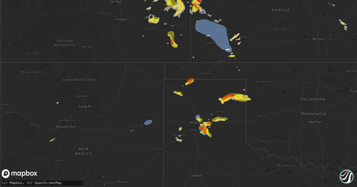
Hail Map on September 9, 2025
Get this storm
September 9 map
$229
one time, instant access
Download today. No call, no setup
Keep the $229
Bought the map and want the full workflow? Apply the entire $229 to a subscription within 7 days. None of it is wasted.
Every map, not just this one
This buys you this map. Subscription and you get every map we run, in the markets you choose from a few cities to whole states to nationwide. Plus real-time alerts the moment a storm fires.
Contact data
Name, contact info, occupancy, even credit band for addresses in the footprint. You go from where it hit to who to call.
Become the source they trust
Unlimited branding weather history reports on demand. You already have the documented answer ready for the property owner, and you are the one who showed up with it.
Property data and RoofTrace estimates
Pull up any address you have got, its value and the exact code rules for that jurisdiction, straight from One Click Code. Then RoofTrace estimates the squares, pitch, and roof value, priced the way you price.
States Impacted by Hail Map on September 9, 2025
Storm reports
Montana
| Date | Description |
|---|---|
| 09/09/20256:50 PM CDT | Corrects previous non-tstm wnd gst report from 10 wsw grant. Mesonet station brrm8 brenner raws. Time is estimated based on radar. |
Colorado
| Date | Description |
|---|---|
| 09/09/20255:12 PM CDT | Hail began at 3:30 pm with up to quarter sized hail accumulating up to a few inches in depth. As of report time... Ongoing hail up to 0.75 inches was falling and smalle |
| 09/09/20255:12 PM CDT | Hail began at 3:30 pm with |
| 09/09/20255:11 PM CDT | Social media photos of hailstones. |
| 09/09/20255:03 PM CDT | Quarter sized hail reported in town. |
| 09/09/20254:59 PM CDT | A local report indicates 1.00 inch wind near Burlington |
| 09/09/20254:45 PM CDT | Estimated quarter to golf ball sized hail that was accumulating. Time estimated based on radar. |
| 09/08/20257:10 PM CDT | Report via social media. Time and location estimated by radar. |
| 09/08/20257:07 PM CDT | A local report indicates 1.75 inch wind near 8 N Springfield |
New Mexico
| Date | Description |
|---|---|
| 09/09/20256:25 PM CDT | Asos station ktcc tucumcari muni airport. |
Texas
| Date | Description |
|---|---|
| 09/09/20256:50 PM CDT | Snapped 1-4 inch tree limbs north of elementary school. |
| 09/09/20255:58 PM CDT | Mesonet station 78 amarillo 9nne. |
| 09/09/20255:50 PM CDT | Storm spotter reported 1 in hail along i 40 north of claude. |
| 09/08/20258:32 PM CDT | A local report indicates 70 MPH wind near 10 ENE Palo Duro Canyon |
Kansas
| Date | Description |
|---|---|
| 09/09/20252:15 AM CDT | Awos station k19s 1 ne sublette. |
| 09/09/20251:08 AM CDT | Mesonet station dw5288 kendall. |
| 09/09/202512:55 AM CDT | Awos station k3k3 syracuse. |
| 09/08/202511:55 PM CDT | Wxunderground kkstribu27. |
| 09/08/202511:53 PM CDT | Delayed report. Nw_tribune_ks awn reported gust. |
| 09/08/202511:53 PM CDT | Corrects previous tstm wnd gst report from 10 wnw saint francis. Delayed report. Nw_tribune_ks awn reported gust. |
| 09/08/202510:10 PM CDT | Delayed report kkskanor6/f1147 reported gust. |
| 09/08/20258:07 PM CDT | A local report indicates 1.25 inch wind near Sharon Springs |
| 09/08/20258:05 PM CDT | Hail up to dime and quarter sized. |
| 09/08/20257:48 PM CDT | Time estimated from radar. |
| 09/08/20257:47 PM CDT | Time estimated by radar. |
| 09/08/20257:45 PM CDT | A local report indicates 1.75 inch wind near 6 W Sharon Springs |
| 09/08/20257:43 PM CDT | Hail approaching golf ball size. |
| 09/08/20257:40 PM CDT | Ping pong ball size hail reported on 4th st. |
Wyoming
| Date | Description |
|---|---|
| 09/08/20258:46 PM CDT | Mesonet station tt610 cody 15 se. |
Cities Impacted by Hail Map on September 9, 2025
- Barnes, KS
- Manhattan, KS
- Madison, MN
- Dell Rapids, SD
- Balaton, MN
- Waterville, KS
- Leonardville, KS
- Clay Center, KS
- Randolph, KS
- Garretson, SD
- Appleton, MN
- Correll, MN
- Olsburg, KS
- Riley, KS
- Marshall, MN
- Cottonwood Falls, KS
- Matfield Green, KS
- Watson, MN
- Montevideo, MN
- Cottonwood, MN
- Hamilton, KS
- Eureka, KS
- Milroy, MN
- Vesta, MN
- Madison, KS
- Herington, KS
- White City, KS
- Hope, NM
- Bethune, CO
- Gering, NE
- Burlington, CO
- Stratton, CO
- Hereford, TX
- Dalhart, TX
- Arthur, NE
- Cuervo, NM
- Iliff, CO
- Peetz, CO
- Broadwater, NE
- Sidney, NE
- Claude, TX
- Joes, CO
- Canyon, TX
- Panhandle, TX
- Groom, TX
- Amarillo, TX
- Fleming, CO
- Fruita, CO
- Grand Junction, CO
- Lamar, CO
- Weskan, KS
- Kanorado, KS
- Friona, TX
- Summerfield, TX
- Las Animas, CO
- Lisco, NE
- Stratford, TX
- Springfield, CO
- Tucumcari, NM
- Dimmitt, TX
- Haxtun, CO
- Kirk, CO
- Happy, TX
- Wayside, TX
- Sharon Springs, KS
- Texhoma, OK
- Wray, CO
- Haigler, NE
- Whitman, NE
- Parks, NE
- Pampa, TX
- Benkelman, NE
- Yuma, CO
- Holyoke, CO
- Mclean, TX
- Miami, TX
- Tribune, KS
- Goodland, KS
- Moore, ID
- Canadian, TX
- Perryton, TX
- Laguna, NM
- Karval, CO
- Sugar City, CO
- Arriba, CO
- Jarales, NM
- Higgins, TX
- Idalia, CO
- Dalton, NE
- Flagler, CO
- La Junta, CO
- Arnett, OK
- Durham, OK
- Arlington, CO
- Hugo, CO
- Kit Carson, CO
- Cheyenne Wells, CO
- Arapahoe, CO
- Crawford, OK
- Eads, CO
- Wild Horse, CO
- Sheridan Lake, CO
- Valentine, NE
- Leoti, KS
- Deerfield, KS
- Holcomb, KS
- Copeland, KS
- Hasty, CO
- McClave, CO
- Montezuma, KS
- Ensign, KS
- Grinnell, KS
- Ingalls, KS
- Cimarron, KS
- Gove, KS
- Garden City, KS
- Scott City, KS
- Grainfield, KS
- Lakin, KS
- Plains, KS
- Kismet, KS
- Sublette, KS
- Syracuse, KS
- Kendall, KS
- Ulysses, KS
- Satanta, KS
- Pierceville, KS
- Meade, KS