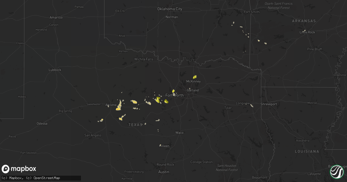
Hail Map on September 5, 2022
Get this storm
September 5 map
$229
one time, instant access
Download today. No call, no setup
Keep the $229
Bought the map and want the full workflow? Apply the entire $229 to a subscription within 7 days. None of it is wasted.
Every map, not just this one
This buys you this map. Subscription and you get every map we run, in the markets you choose from a few cities to whole states to nationwide. Plus real-time alerts the moment a storm fires.
Contact data
Name, contact info, occupancy, even credit band for addresses in the footprint. You go from where it hit to who to call.
Become the source they trust
Unlimited branding weather history reports on demand. You already have the documented answer ready for the property owner, and you are the one who showed up with it.
Property data and RoofTrace estimates
Pull up any address you have got, its value and the exact code rules for that jurisdiction, straight from One Click Code. Then RoofTrace estimates the squares, pitch, and roof value, priced the way you price.
Storm reports
Arkansas
| Date | Description |
|---|---|
| 09/05/20221:16 AM CDT | At 616 PM CDT, a severe thunderstorm was located over Shady, or 9 miles southeast of Mena, moving northeast at 10 mph. HAZARD...60 mph wind gusts. SOURCE...Radar indicated. IMPACT...Expect damage to roofs, siding, and trees. Locations impacted include... Shady... Caney Creek Wilderness... Opal... Mena Intermountain Airport... Big Fork... Board Camp... Nunley... Cherry Hill in Polk County... Ink... |
Texas
| Date | Description |
|---|---|
| 09/05/20223:36 AM CDT | At 835 PM CDT, a severe thunderstorm was located over Saginaw, and is nearly stationary. HAZARD...60 mph wind gusts and quarter size hail. SOURCE...Radar indicated. IMPACT...Hail damage to vehicles is expected. Expect wind damage to roofs, siding, and trees. Locations impacted include... Fort Worth, Haltom City, Keller, Watauga, Saginaw, River Oaks, Sansom Park, Lake Worth, Eagle Mountain, North Richland Hills, Blue Mound, Haslet and Lakeside.This includes the following highways... Interstate 35W between mile markers 50 and 64. Interstate 30 between mile markers 14 and 17. |
| 09/05/20223:02 AM CDT | At 802 PM CDT, a severe thunderstorm was located 8 miles south of Marshall, moving southeast at 10 mph. HAZARD...60 mph wind gusts and quarter size hail. SOURCE...Radar indicated. IMPACT...Hail damage to vehicles is expected. Expect wind damage to roofs, siding, and trees. This severe thunderstorm will remain over mainly rural areas of south central Harrison County. |
| 09/05/20221:50 AM CDT | At 650 PM CDT, a severe thunderstorm was located 7 miles northeast of Lipan, or 15 miles northwest of Granbury, moving east at 15 mph. HAZARD...60 mph wind gusts and quarter size hail. SOURCE...Radar indicated. IMPACT...Hail damage to vehicles is expected. Expect wind damage to roofs, siding, and trees. Locations impacted include... Weatherford, Granbury, Willow Park, Aledo, Hudson Oaks, Annetta, Lipan, Oak Trail Shores, Annetta South and Annetta North.This includes Interstate 20 between mile markers 392 and 401, andbetween mile markers 403 and 419. |
| 09/05/202212:13 AM CDT | At 512 PM CDT, a severe thunderstorm was located near Gunsight, or 7 miles north of Eastland, moving east at 15 mph. HAZARD...60 mph wind gusts and half dollar size hail. SOURCE...Radar indicated. IMPACT...Hail damage to vehicles is expected. Expect wind damage to roofs, siding, and trees. Locations impacted include... Eastland, Ranger, Gorman and Strawn. This includes Interstate 20 between mile markers 340 and 363. |
| 09/04/202210:53 PM CDT | At 353 PM CDT, a severe thunderstorm was located 7 miles south of Baird, moving east at 15 mph. HAZARD...Golf ball size hail and 60 mph wind gusts. SOURCE...Radar indicated. IMPACT...People and animals outdoors will be injured. Expect hail damage to roofs, siding, windows, and vehicles. Expect wind damage to roofs, siding, and trees. This severe thunderstorm will be near... Rowden around 420 PM CDT. Cross Plains and Atwell around 500 PM CDT.Other locations impacted by this severe thunderstorm include Admiraland I-20 Near The Callahan-Eastland County Line.This includes Interstate 20 between Mile Markers 298 and 323. |
| 09/04/202210:00 PM CDT | At 300 PM CDT, a severe thunderstorm was located near Us-283 Near The Callahan-Shackelford County Line, or 11 miles north of Baird, moving south at 10 mph. HAZARD...60 mph wind gusts and quarter size hail. SOURCE...Radar indicated. IMPACT...Hail damage to vehicles is expected. Expect wind damage to roofs, siding, and trees. This severe thunderstorm will be near... Baird around 400 PM CDT.Other locations impacted by this severe thunderstorm include Admiral,I-20 Near The Callahan-Eastland County Line and Us-283 Near The Callahan-Shackelford County Line.This includes Interstate 20 between Mile Markers 299 and 323. |
| 09/04/20229:55 PM CDT | At 255 PM CDT, a severe thunderstorm was located over Dyess Afb, moving south at 10 mph. HAZARD...60 mph wind gusts and quarter size hail. SOURCE...Radar indicated. IMPACT...Hail damage to vehicles is expected. Expect wind damage to roofs, siding, and trees. This severe thunderstorm will be near... Wylie and Caps around 315 PM CDT. View around 330 PM CDT. Buffalo Gap around 340 PM CDT. Tuscola and Coronados Camp around 400 PM CDT.Other locations impacted by this severe thunderstorm include Impact,Lake Abilene, Camp Tonkawa, Kirby Lake and Ovalo.This includes Interstate 20 between Mile Markers 269 and 292. |
| 09/04/20229:32 PM CDT | At 232 PM CDT, a severe thunderstorm was located near Pumphrey, or near Wingate, moving south at 5 mph. HAZARD...60 mph wind gusts and quarter size hail. SOURCE...Radar indicated. IMPACT...Hail damage to vehicles is expected. Expect wind damage to roofs, siding, and trees. This severe thunderstorm will be near... Norton around 315 PM CDT.Other locations impacted by this severe thunderstorm includePumphrey, Wilmeth and Drasco. |
| 09/04/20228:46 PM CDT | Report from mping: half dollar |
| 09/04/20228:44 PM CDT | 1-inch diameter hail on the north side of saginaw. |
| 09/04/20228:41 PM CDT | Report from mping: quarter |
| 09/04/20228:37 PM CDT | Report from mping: quarter |
| 09/04/20227:14 PM CDT | Quarter sized hail. |
Cities Impacted by Hail Map on September 5, 2022
- Winters, TX
- Strawn, TX
- Fort Worth, TX
- Caddo Gap, AR
- Dyess Afb, TX
- Abilene, TX
- Baird, TX
- Clyde, TX
- Burkett, TX
- Broken Bow, OK
- Carbon, TX
- Eastland, TX
- Cisco, TX
- Haslet, TX
- Anna, TX
- Granbury, TX
- Cresson, TX
- Bronte, TX
- Red Oak, OK
- Santo, TX
- Richardson, TX
- Dallas, TX
- Mena, AR
- Lipan, TX
- Millsap, TX
- Weatherford, TX
- Norton, TX
- Breckenridge, TX
- Ranger, TX
- Gordon, TX
- Mineral Wells, TX
- Little Rock, AR
- Gustine, TX
- Longview, TX
- Fort Hood, TX
- Albany, TX
- Copperas Cove, TX
- Cross Plains, TX
- Melissa, TX
- Lawrenceville, IL
- Stephenville, TX
- Haltom City, TX
- Marshall, TX
- Mingus, TX
- Jonesboro, TX
- Gorman, TX
- Heavener, OK
- Comanche, TX
- Stilwell, OK
- Hico, TX
- Iredell, TX
- Madison, IN
- Milton, KY
- North Little Rock, AR
- Godley, TX
- Mckinney, TX