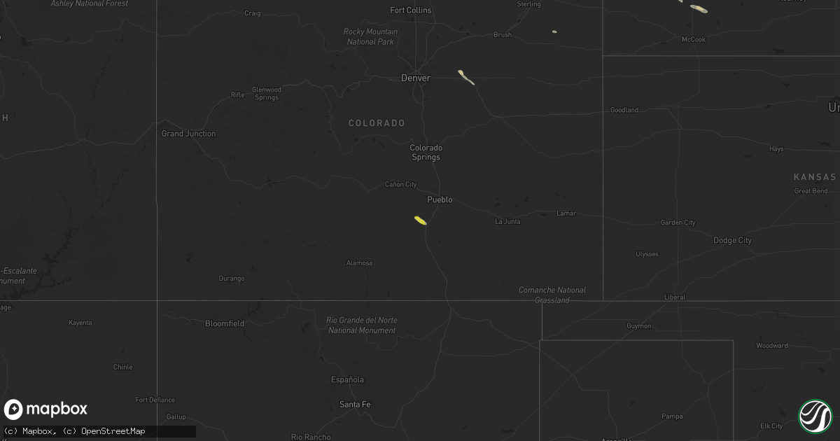
Hail Map on September 4, 2021
Get this storm
September 4 map
$229
one time, instant access
Download today. No call, no setup
Keep the $229
Bought the map and want the full workflow? Apply the entire $229 to a subscription within 7 days. None of it is wasted.
Every map, not just this one
This buys you this map. Subscription and you get every map we run, in the markets you choose from a few cities to whole states to nationwide. Plus real-time alerts the moment a storm fires.
Contact data
Name, contact info, occupancy, even credit band for addresses in the footprint. You go from where it hit to who to call.
Become the source they trust
Unlimited branding weather history reports on demand. You already have the documented answer ready for the property owner, and you are the one who showed up with it.
Property data and RoofTrace estimates
Pull up any address you have got, its value and the exact code rules for that jurisdiction, straight from One Click Code. Then RoofTrace estimates the squares, pitch, and roof value, priced the way you price.
States Impacted by Hail Map on September 4, 2021
Storm reports
Oklahoma
| Date | Description |
|---|---|
| 09/04/20215:00 PM CDT | Damage reported to trees and power lines near ne 10th street and luther road. |
Missouri
| Date | Description |
|---|---|
| 09/04/20211:45 AM CDT | At 644 PM CDT, a severe thunderstorm was located 9 miles southwest of Willow Springs, moving east at 25 mph. HAZARD...60 mph wind gusts. SOURCE...Radar indicated. IMPACT...Expect damage to roofs, siding, and trees. Locations impacted include... West Plains... Pomona... Peace Valley... Siloam Springs... White Church... |
New Mexico
| Date | Description |
|---|---|
| 09/04/20213:27 AM CDT | At 826 PM MDT, a severe thunderstorm was located over Moriarty, moving southeast at 10 mph. HAZARD...60 mph wind gusts and quarter size hail. SOURCE...Radar indicated. IMPACT...Hail damage to vehicles is expected. Expect wind damage to roofs, siding, and trees. Locations impacted include... Edgewood and Moriarty. This includes Interstate 40 between Mile Markers 189 and 204. |
| 09/03/20219:45 PM CDT | Thunderstorm wind damage resulted in downed trees and power outages. A residents above ground cistern was also moved by the strong winds. |
Nebraska
| Date | Description |
|---|---|
| 09/04/20214:30 AM CDT | Delayed report. Time estimated from radar |
| 09/04/20213:40 AM CDT | Time estimated from radar |
Colorado
| Date | Description |
|---|---|
| 09/04/20211:32 AM CDT | At 631 PM MDT, a severe thunderstorm was located 10 miles northeast of Greenhorn Mountain, or 16 miles southeast of Junkins Burn Scar, moving southeast at 20 mph. HAZARD...60 mph wind gusts and quarter size hail. SOURCE...Radar indicated. IMPACT...Hail damage to vehicles is expected. Expect wind damage to roofs, siding, and trees. Locations impacted include... Rye and Colorado City. |
Florida
| Date | Description |
|---|---|
| 09/03/202110:29 PM CDT | At 329 PM EDT, a severe thunderstorm was located over Chambers Estates, or near Hollywood, and is nearly stationary. HAZARD...60 mph wind gusts. SOURCE...Radar indicated. IMPACT...Expect damage to roofs, siding, and trees. Locations impacted include... Fort Lauderdale, Pembroke Pines, Hollywood, Davie and Dania Beach. |
Cities Impacted by Hail Map on September 4, 2021
- Sutherland, NE
- Hershey, NE
- Arthur, NE
- Keystone, NE
- Paxton, NE
- Lemoyne, NE
- Lewellen, NE
- Portales, NM
- Strasburg, CO
- Wellfleet, NE
- North Platte, NE
- Pueblo, CO
- Maywood, NE
- Curtis, NE
- Taylor, NE
- Byers, CO
- Ainsworth, NE
- Paducah, TX
- Bristow, OK
- Elida, NM
- Dickens, NE
- Carlsbad, NM
- Burwell, NE
- Roswell, NM
- Rye, CO
- Beulah, CO
- Colorado City, CO
- Texico, NM
- Yuma, CO
- Otis, CO
- Loup City, NE
- Stockville, NE
- Moriarty, NM
- Edgewood, NM
- Stanley, NM
- Bonesteel, SD
- Farnam, NE
- Hayes Center, NE
- Brady, NE
- Ogallala, NE
- Frederick, OK