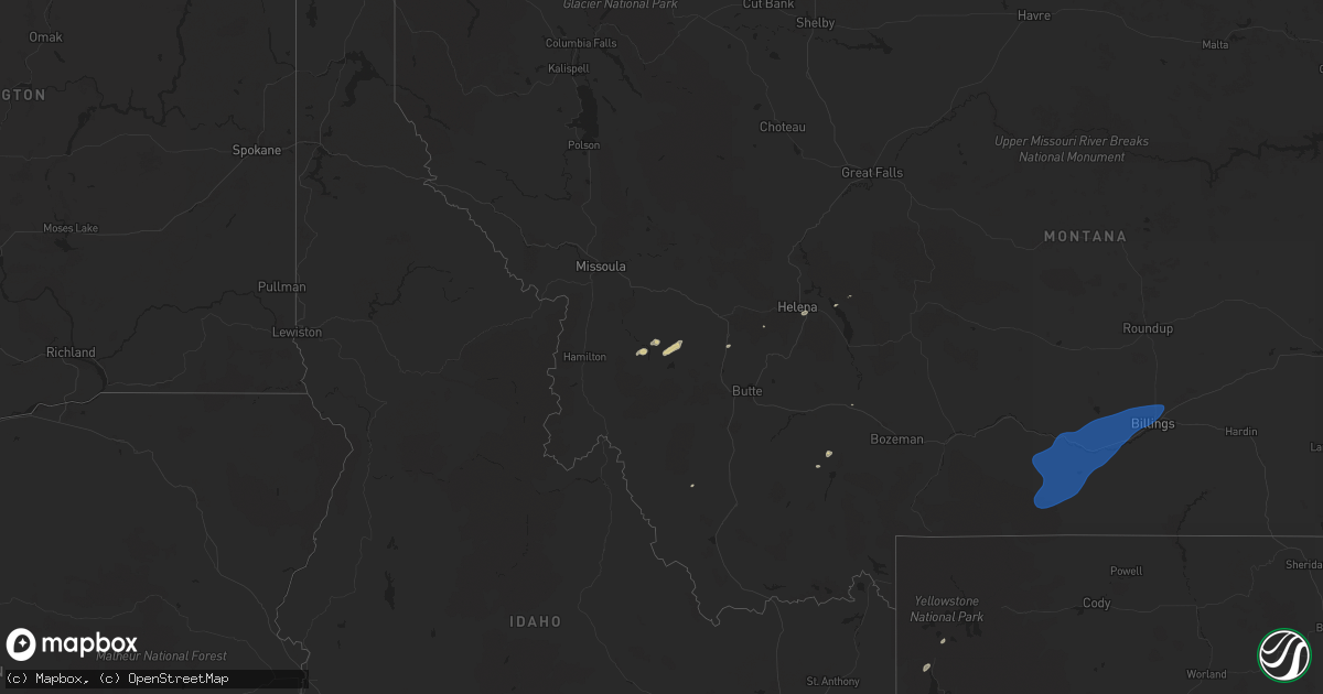
Hail Map on September 3, 2024
Get this storm
September 3 map
$229
one time, instant access
Download today. No call, no setup
Keep the $229
Bought the map and want the full workflow? Apply the entire $229 to a subscription within 7 days. None of it is wasted.
Every map, not just this one
This buys you this map. Subscription and you get every map we run, in the markets you choose from a few cities to whole states to nationwide. Plus real-time alerts the moment a storm fires.
Contact data
Name, contact info, occupancy, even credit band for addresses in the footprint. You go from where it hit to who to call.
Become the source they trust
Unlimited branding weather history reports on demand. You already have the documented answer ready for the property owner, and you are the one who showed up with it.
Property data and RoofTrace estimates
Pull up any address you have got, its value and the exact code rules for that jurisdiction, straight from One Click Code. Then RoofTrace estimates the squares, pitch, and roof value, priced the way you price.
States Impacted by Hail Map on September 3, 2024
Storm reports
Montana
| Date | Description |
|---|---|
| 09/03/20244:35 PM CDT | Billings s mesonet. |
| 09/03/20244:34 PM CDT | A local report indicates 58 MPH wind near 2.5 E Molt |
| 09/03/20244:21 PM CDT | Laurel airport. |
| 09/03/20243:50 PM CDT | Cooney reservoir mesonet. |
| 09/03/20243:32 PM CDT | Gust estimated. |
Utah
| Date | Description |
|---|---|
| 09/03/20246:20 PM CDT | Mesonet station utedl i-80 at mp 71 east delle. |
| 09/03/20246:20 PM CDT | Mesonet station utwdl i-80 at mp 68 west delle. |
| 09/03/20245:50 PM CDT | Mesonet station pc298 the head. |
| 09/03/20244:30 PM CDT | Mesonet station vrh vernon hill. |
| 09/02/20249:30 PM CDT | Mesonet station hdp central wasatch peaks - west. |
| 09/02/20247:00 PM CDT | Mesonet station amb central wasatch peaks - east. |
South Dakota
| Date | Description |
|---|---|
| 09/03/20245:57 PM CDT | A local report indicates 64 MPH wind near 12 E Oelrichs |
Wyoming
| Date | Description |
|---|---|
| 09/03/20246:52 PM CDT | Asos station kwrl worland airport. |
| 09/03/20246:43 PM CDT | Asos station kevw evanston-uinta cnty airport. |
| 09/03/20246:42 PM CDT | Corrects previous tstm wnd gst report from 3 s worland. Asos station kwrl worland airport. |
| 09/03/20245:43 PM CDT | Asos station kgey greybull airport. |
| 09/03/20244:21 PM CDT | Asos station krks rock springs airport. |
| 09/03/20243:59 PM CDT | Corrects previous tstm wnd gst report from 8 se reliance. Asos station krks rock springs airport. |
| 09/02/20247:00 PM CDT | Mesonet station pc450 evanston north. |
Cities Impacted by Hail Map on September 3, 2024
- Deer Lodge, MT
- Philipsburg, MT
- Clancy, MT
- Helena, MT
- Port Isabel, TX
- Brownsville, TX
- Fishtail, MT
- Roscoe, MT
- Red Lodge, MT
- Roberts, MT
- Absarokee, MT
- Joliet, MT
- Columbus, MT
- Laurel, MT
- Park City, MT
- Bridger, MT
- Billings, MT
- Molt, MT
- Big Timber, MT
- Reed Point, MT
- Nye, MT
- Acton, MT
- McAllister, MT
- Huntley, MT
- Shepherd, MT
- Three Forks, MT
- Norris, MT
- Oelrichs, SD
- Pine Ridge, SD