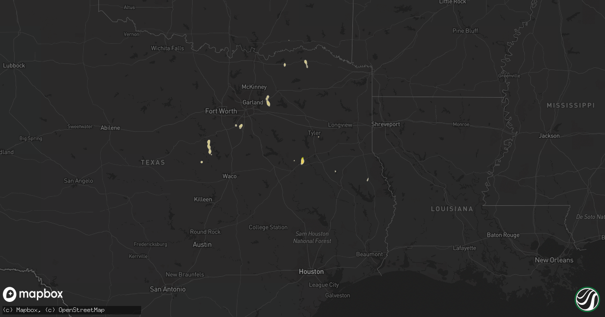
Hail Map on September 3, 2023
Get this storm
September 3 map
$229
one time, instant access
Download today. No call, no setup
Keep the $229
Bought the map and want the full workflow? Apply the entire $229 to a subscription within 7 days. None of it is wasted.
Every map, not just this one
This buys you this map. Subscription and you get every map we run, in the markets you choose from a few cities to whole states to nationwide. Plus real-time alerts the moment a storm fires.
Contact data
Name, contact info, occupancy, even credit band for addresses in the footprint. You go from where it hit to who to call.
Become the source they trust
Unlimited branding weather history reports on demand. You already have the documented answer ready for the property owner, and you are the one who showed up with it.
Property data and RoofTrace estimates
Pull up any address you have got, its value and the exact code rules for that jurisdiction, straight from One Click Code. Then RoofTrace estimates the squares, pitch, and roof value, priced the way you price.
Storm reports
Texas
| Date | Description |
|---|---|
| 09/03/20234:45 PM CDT | Power poles down between bells and whitewright. |
| 09/02/20239:15 PM CDT | Report from mping: half dollar |
| 09/02/20239:10 PM CDT | Report from mping: quarter |
Nevada
| Date | Description |
|---|---|
| 09/03/20236:25 PM CDT | Mesonet station wspnv 6.3 s clover valley |
| 09/03/20235:11 PM CDT | Raws site mather |
| 09/03/20234:38 PM CDT | Raws coils creek |
| 09/03/20232:05 PM CDT | Raws site giants grave |
| 09/02/20237:41 PM CDT | Mesonet station alln2 alligator ridge raws station elevation: 6674 ft. |
Utah
| Date | Description |
|---|---|
| 09/03/20234:21 PM CDT | A local report indicates 64 MPH wind near 16 W Knolls |
| 09/03/20234:20 PM CDT | A local report indicates 60 MPH wind near 14 W Knolls |
Washington
| Date | Description |
|---|---|
| 09/02/20238:45 PM CDT | Thunderstorm damage. Power outage via local power company. |
| 09/02/20238:40 PM CDT | Thunderstorm damage. Power outage via local power company. Estimated 300 customers at this time. |
| 09/02/20237:25 PM CDT | Corrects previous tstm wnd dmg report from 5 wsw boyds. Thunderstorm damage. Power outage via local power company. |
South Dakota
| Date | Description |
|---|---|
| 09/03/202312:42 AM CDT | A local report indicates 58 MPH wind near 4 E Cactus Flat |
| 09/03/202312:38 AM CDT | A local report indicates 66 MPH wind near 7 E Wanblee |
| 09/02/202311:41 PM CDT | A local report indicates 65 MPH wind near 5 NE Porcupine |
| 09/02/202310:10 PM CDT | A local report indicates 64 MPH wind near 3 ESE Pine Ridge |
Montana
| Date | Description |
|---|---|
| 09/02/20237:52 PM CDT | Mesonet station jpkm8 judith peak raws. Occurred some time within the previous hour. Station elevation: 6428 ft. |
| 09/02/20237:16 PM CDT | Asos station klwt lewistown airport. Secondary peak wind gust from outflow boundary. |
| 09/02/20237:09 PM CDT | Asos station klwt lewistown airport. Peak wind gust associated with outflow boundary. |
Cities Impacted by Hail Map on September 3, 2023
- Fallon, NV
- Imlay, NV
- Eureka, NV
- Battle Mountain, NV
- Montello, NV
- Windom, TX
- Honey Grove, TX
- Royse City, TX
- Terrell, TX
- Austin, NV
- Cleburne, TX
- Kopperl, TX
- Gabbs, NV
- Rockwall, TX
- Nevada, TX
- Blackfoot, ID
- Shelley, ID
- Firth, ID
- Paris, TX
- Morgan, TX
- Wells, NV
- Boswell, OK
- Elko, NV
- Pattonville, TX
- Cranfills Gap, TX
- Montpelier, ID
- Palestine, TX
- Whitehouse, TX
- Logan, UT
- Lava Hot Springs, ID
- Downey, ID
- Midlothian, TX
- Waxahachie, TX
- Red Oak, TX
- Snowville, UT
- Park Valley, UT
- Grouse Creek, UT
- Providence, UT
- Hyde Park, UT
- Wellsville, UT
- Meridian, TX
- Malad City, ID
- Sedalia, CO
- Tennessee Colony, TX
- San Augustine, TX
- Kenmare, ND
- Douglass, TX