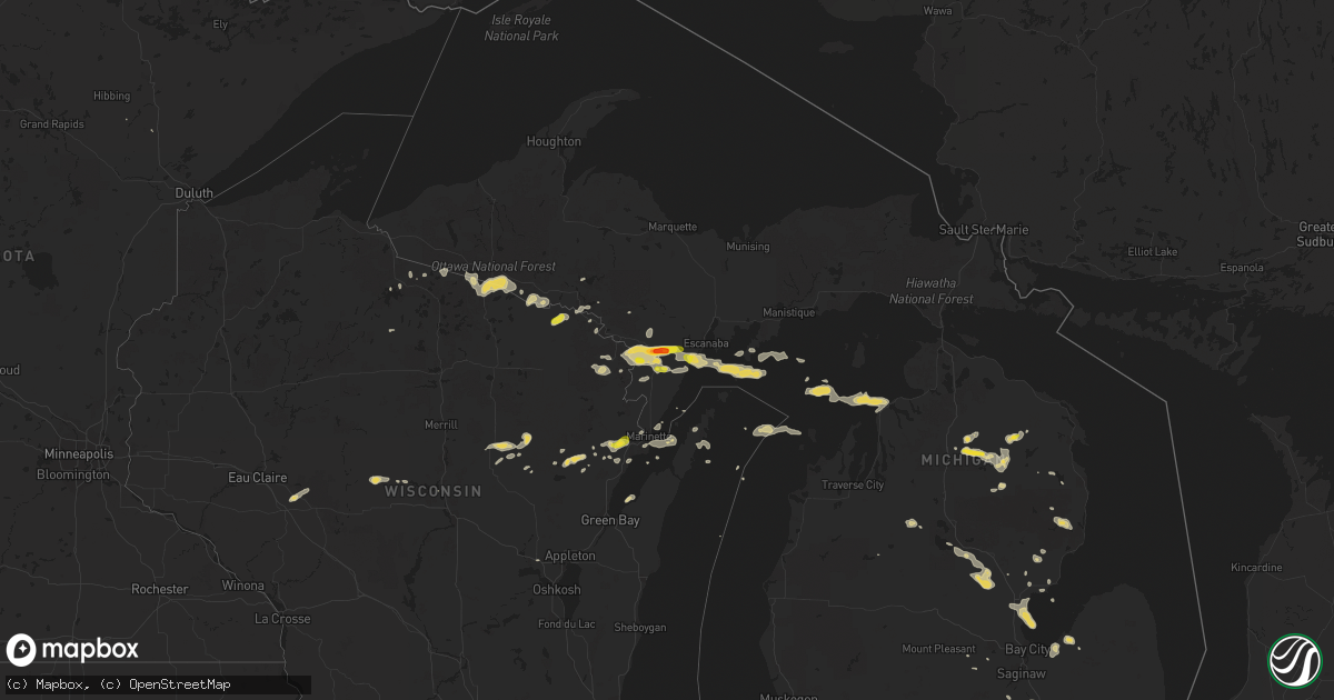
Hail Map on September 2, 2015
Get this storm
September 2 map
$229
one time, instant access
Download today. No call, no setup
Keep the $229
Bought the map and want the full workflow? Apply the entire $229 to a subscription within 7 days. None of it is wasted.
Every map, not just this one
This buys you this map. Subscription and you get every map we run, in the markets you choose from a few cities to whole states to nationwide. Plus real-time alerts the moment a storm fires.
Contact data
Name, contact info, occupancy, even credit band for addresses in the footprint. You go from where it hit to who to call.
Become the source they trust
Unlimited branding weather history reports on demand. You already have the documented answer ready for the property owner, and you are the one who showed up with it.
Property data and RoofTrace estimates
Pull up any address you have got, its value and the exact code rules for that jurisdiction, straight from One Click Code. Then RoofTrace estimates the squares, pitch, and roof value, priced the way you price.
States Impacted by Hail Map on September 2, 2015
Storm reports
Michigan
| Date | Description |
|---|---|
| 09/02/20155:46 PM CDT | Asos station roscommon county airport /htl/ |
| 09/02/201511:22 AM CDT | A local report indicates 1.00 inch wind near 3 E WILSON |
| 09/02/201511:20 AM CDT | Trained spotter reports quarter sized hail for a brief period. |
| 09/02/201511:18 AM CDT | A local report indicates 1.75 inch wind near 1 E POWERS |
| 09/02/20158:12 AM CDT | 10 inch diameter tree downed at moon and jewell roads |
| 09/02/201512:05 AM CDT | Delayed report relayed by broadcast media: public reported a tree had fallen on their mobile home and door to a shed was damaged. Tree limbs scattered throughout the ar |
Virginia
| Date | Description |
|---|---|
| 09/02/20155:05 PM CDT | Time is radar estimated. Trees downed along anderson highway in western powhatan county. Dime size hail also reported. |
| 09/02/20154:00 PM CDT | Several trees down across the center of buena vista. Time estimated by radar. |
| 09/02/20154:00 PM CDT | Line down across middle road. Time estimated by radar. |
| 09/02/20153:30 PM CDT | A large tree fell on a vehicle. Another tree downed nearby. |
| 09/02/20153:11 PM CDT | Large limbs blown down from several trees. Time based on radar. |
| 09/02/20152:57 PM CDT | Several tree limbs were down in the road near graves mountain lodge. |
| 09/02/20152:43 PM CDT | Quarter size hail |
| 09/02/20152:42 PM CDT | Several tree limbs were snapped near the intersection of church hill road and route 231. |
| 09/02/20152:32 PM CDT | Large cedar tree down near charlotte ln |
| 09/02/20152:30 PM CDT | A local report indicates 1.00 inch wind near 3 E JEROME |
| 09/02/20152:22 PM CDT | A local report indicates 1.00 inch wind near 2 SE NETHERS |
| 09/02/20152:10 PM CDT | Penny to quarter size hail |
| 09/02/20151:58 PM CDT | Estimated to be a little bigger than a quarter |
Ohio
| Date | Description |
|---|---|
| 09/02/20156:20 PM CDT | 3 trees down |
| 09/02/20153:40 PM CDT | 8 to 10 trees either sheared or uprooted in the vicinity of pidgeon run ave sw and poorman st sw in navarre. Time of event is estimated from radar. |
| 09/02/20153:36 PM CDT | 1 tree down |
Montana
| Date | Description |
|---|---|
| 09/02/20153:48 PM CDT | A local report indicates 60 MPH wind near 3 WNW MILES CITY |
Wisconsin
| Date | Description |
|---|---|
| 09/02/20153:41 PM CDT | In the township of grover. Via social media. |
| 09/02/20159:20 AM CDT | A couple trees down on hwy 70. Torrential rain occurred during high winds. |
| 09/02/20159:20 AM CDT | Quarter-size hail found on the ground about a half hour after storm moved through. |
Maryland
| Date | Description |
|---|---|
| 09/02/201512:59 PM CDT | Tree and power lines down in 1500 block of frederick st |
Cities Impacted by Hail Map on September 2, 2015
- Saint Helen, MI
- Gillett, WI
- Garden, MI
- Pembine, WI
- Amberg, WI
- Dunbar, WI
- Gaylord, MI
- Partlow, VA
- Lawrenceville, VA
- Augusta, WI
- Spencer, WI
- Vail, AZ
- Holland, MI
- Pie Town, NM
- Quemado, NM
- Carney, MI
- McConnellsburg, PA
- Harrisonville, PA
- Vesuvius, VA
- Raphine, VA
- Mount Jackson, VA
- Edinburg, VA
- Davisburg, MI
- Holly, MI
- Mercer, WI
- Keshena, WI
- Suring, WI
- Brodnax, VA
- Marinette, WI
- Powhatan, VA
- Summit Point, WV
- Berryville, VA
- Kearneysville, WV
- Standish, MI
- Bentley, MI
- Pinconning, MI
- Alger, MI
- Wilson, MI
- Powers, MI
- Spalding, MI
- Bark River, MI
- Hermansville, MI
- Niagara, WI
- Stephenson, MI
- Daggett, MI
- Vulcan, MI
- Nadeau, MI
- Swoope, VA
- Middlebrook, VA
- Craigsville, VA
- Stryker, OH
- Stratford, WI
- Coleman, WI
- Peshtigo, WI
- Birnamwood, WI
- Bowler, WI
- Zeeland, MI
- Rhodes, MI
- West Branch, MI
- Gladwin, MI
- Prudenville, MI
- Oconto, WI
- Lena, WI
- Lake City, MI
- Gaston, NC
- Emporia, VA
- Garysburg, NC
- Pleasant Hill, NC
- Skippers, VA
- San Simon, AZ
- Comins, MI
- Lewiston, MI
- Atlanta, MI
- Johannesburg, MI
- Hillman, MI
- Masontown, PA
- Fulks Run, VA
- Bergton, VA
- Criders, VA
- Tyro, VA
- Roseland, VA
- Au Gres, MI
- Houghton Lake, MI
- Bentonville, VA
- Gresham, WI
- Ormond Beach, FL
- Land O'Lakes, WI
- Phelps, WI
- Watersmeet, MI
- Farmville, VA
- Waynesboro, PA
- Waterville, OH
- Whitehouse, OH
- Monclova, OH
- Winchester, VA
- Oconto Falls, WI
- Chesapeake, VA
- Norfolk, VA
- Portsmouth, VA
- Glennie, MI
- Charles Town, WV
- Ranson, WV
- Spruce, MI
- Mio, MI
- Fairview, MI
- Gasburg, VA
- White Plains, VA
- Pound, WI
- Stoystown, PA
- Antigo, WI
- Presque Isle, WI
- Stanley, VA
- Long Lake, WI
- Iron River, MI
- Unity, WI
- Unionville, MI
- Baileys Harbor, WI
- Charlevoix, MI
- Florence, WI
- Oscoda, MI
- Steeles Tavern, VA
- Smithsburg, MD
- Clear Brook, VA
- Stephenson, VA
- Curran, MI
- Ephraim, WI
- Sister Bay, WI
- Fish Creek, WI
- Sebewaing, MI
- Saint Louis, MI
- Cumberland, VA
- Cartersville, VA
- Freeland, MI
- Whittemore, MI
- Perronville, MI
- Union Bridge, MD
- Mount Airy, MD
- Fairgrove, MI
- Reese, MI
- Akron, MI
- Mikado, MI
- Greensboro, PA
- Carmichaels, PA
- Basye, VA
- Neopit, WI
- Aniwa, WI
- White Lake, WI
- Mattoon, WI
- Conway, NC
- Middletown, MD
- Wheeler, MI
- Mathias, WV
- Etlan, VA
- Crystal Falls, MI
- Sperryville, VA
- Syria, VA
- Twining, MI
- National City, MI
- Tawas City, MI
- Conover, WI
- Lapeer, MI
- Leonard, MI
- Oakland, MI
- Woodford, VA
- Ruther Glen, VA
- Wittenberg, WI
- Amelia Court House, VA
- Quicksburg, VA
- Fredericksburg, VA
- Woodland, NC
- Larsen, WI
- Metamora, MI
- Saint Charles, MI
- Chesaning, MI
- Romeo, MI
- Upper Tract, WV
- Daytona Beach, FL
- Madison, VA
- Purcellville, VA
- Keyser, WV
- Waynesboro, VA
- Hustontown, PA
- Fort Loudon, PA
- Northport, MI
- Clio, MI
- Birch Run, MI
- Montrose, MI
- Memphis, TN
- Dayton, OH
- Omer, MI
- Cochise, AZ
- Moorefield, WV