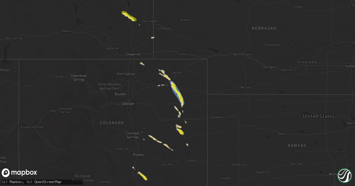
Hail Map on August 28, 2025
Get this storm
August 28 map
$229
one time, instant access
Download today. No call, no setup
Keep the $229
Bought the map and want the full workflow? Apply the entire $229 to a subscription within 7 days. None of it is wasted.
Every map, not just this one
This buys you this map. Subscription and you get every map we run, in the markets you choose from a few cities to whole states to nationwide. Plus real-time alerts the moment a storm fires.
Contact data
Name, contact info, occupancy, even credit band for addresses in the footprint. You go from where it hit to who to call.
Become the source they trust
Unlimited branding weather history reports on demand. You already have the documented answer ready for the property owner, and you are the one who showed up with it.
Property data and RoofTrace estimates
Pull up any address you have got, its value and the exact code rules for that jurisdiction, straight from One Click Code. Then RoofTrace estimates the squares, pitch, and roof value, priced the way you price.
States Impacted by Hail Map on August 28, 2025
Storm reports
Louisiana
| Date | Description |
|---|---|
| 08/28/20254:48 PM CDT | Trees down at the intersection of la hwy 2 & 518. |
| 08/28/20254:43 PM CDT | Trees down at the intersection of la hwy 2 and greer road. |
| 08/28/20254:12 PM CDT | Trees down in the city of haynesville. |
Florida
| Date | Description |
|---|---|
| 08/28/20252:43 PM CDT | Social media video depicts a tornado in rural palm beach county near pahokee. No damage reported as it remained over rural farmland and was short-lived. Rating is ef-u. |
| 08/28/20252:20 PM CDT | Putnam county sheriff reported trees and powerlines were blown down along silverlake drive. The time of damage was based on radar. |
| 08/28/20252:17 PM CDT | Multiple trees and power lines down near karen lane and fl 19 southwest of palatka. Time estimated via radar. |
Texas
| Date | Description |
|---|---|
| 08/28/20256:05 PM CDT | Trees across hwy 154e. |
| 08/28/20255:42 PM CDT | Trees down over state hwy 154w. |
| 08/28/20255:07 PM CDT | 64 mph wind gusts recorded 1 mile north of decatur with a personal weather station. |
| 08/28/20254:25 PM CDT | [landspout] several photos and videos on social media of a landspout in the providence village and little elm area. |
Colorado
| Date | Description |
|---|---|
| 08/27/20257:31 PM CDT | A local report indicates 78 MPH wind near 1 W Akron |
| 08/27/20257:31 PM CDT | A local report indicates 87 MPH wind near 1 NNW Akron |
| 08/27/20257:27 PM CDT | A local report indicates 63 MPH wind near 1 WNW Akron |
Cities Impacted by Hail Map on August 28, 2025
- Wheatland, WY
- Interlachen, FL
- Denison, TX
- Pottsboro, TX
- Palatka, FL
- Sherman, TX
- Bonham, TX
- Guernsey, WY
- Dodd City, TX
- Nocona, TX
- Ironside, OR
- New Augusta, MS
- Magnolia, AR
- Emerson, AR
- Haynesville, LA
- Shongaloo, LA
- Yoder, WY
- Lagrange, WY
- Homer, LA
- Pilot Point, TX
- Summerfield, LA
- Bernice, LA
- Lisbon, LA
- Celina, TX
- Arcadia, LA
- Mosquero, NM
- Decatur, TX
- Dubach, LA
- Alvord, TX
- Quanah, TX
- Moore Haven, FL
- Stoneham, CO
- New Raymer, CO
- Jacksboro, TX
- Bowie, TX
- Choudrant, LA
- Ruston, LA
- Rye, CO
- Merino, CO
- Snyder, CO
- Grayson, LA
- Burke, SD
- Akron, CO
- Columbia, LA
- Walsenburg, CO
- Grover, CO
- Hillrose, CO
- Otis, CO
- Model, CO
- Jena, LA
- Harrisonburg, LA
- Olla, LA
- Anton, CO
- Melrose, LA
- Natchez, LA
- Cloutierville, LA
- Cope, CO
- Gladstone, NM
- Colfax, LA
- Flagler, CO
- Fort Morgan, CO
- De Kalb, TX
- Pineville, LA
- Boyce, LA
- Log Lane Village, CO
- Brush, CO
- Simpson, LA
- Leesville, LA
- Seibert, CO
- Ault, CO
- Colorado Springs, CO
- Hugo, CO
- Wild Horse, CO
- Kit Carson, CO
- Eads, CO
- Peyton, CO
- Yoder, CO
- Rush, CO
- Ordway, CO
- Keatchie, LA
- Grand Cane, LA
- Karval, CO
- Sugar City, CO
- Logansport, LA
- Arlington, CO
- Joaquin, TX