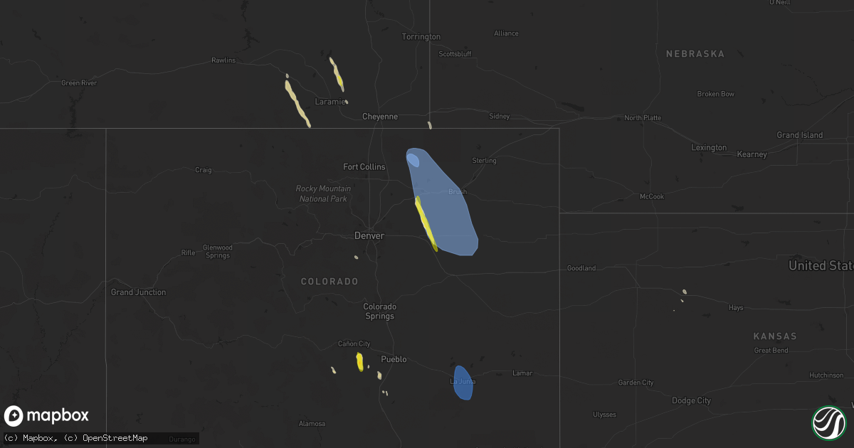
Hail Map on August 28, 2023
Get this storm
August 28 map
$229
one time, instant access
Download today. No call, no setup
Keep the $229
Bought the map and want the full workflow? Apply the entire $229 to a subscription within 7 days. None of it is wasted.
Every map, not just this one
This buys you this map. Subscription and you get every map we run, in the markets you choose from a few cities to whole states to nationwide. Plus real-time alerts the moment a storm fires.
Contact data
Name, contact info, occupancy, even credit band for addresses in the footprint. You go from where it hit to who to call.
Become the source they trust
Unlimited branding weather history reports on demand. You already have the documented answer ready for the property owner, and you are the one who showed up with it.
Property data and RoofTrace estimates
Pull up any address you have got, its value and the exact code rules for that jurisdiction, straight from One Click Code. Then RoofTrace estimates the squares, pitch, and roof value, priced the way you price.
States Impacted by Hail Map on August 28, 2023
Storm reports
Wisconsin
| Date | Description |
|---|---|
| 08/28/20236:40 PM CDT | Several branches down. Small tree split in two. Spotter also reported some damage to docks and pontoons at devils lake. |
| 08/27/20237:06 PM CDT | Photo sent in via social media of an 8 inch diameter tree that was snapped. Observer notes that the tree already had a scar on it. Time estimated from radar. |
| 08/27/20237:00 PM CDT | Also had several trees downed including oak... Pine... And maple. Time estimated from radar. |
| 08/27/20237:00 PM CDT | Several maple... Oak... And pine trees blown down. Also had 1 inch diameter hail. Time estimated from radar. |
Georgia
| Date | Description |
|---|---|
| 08/28/20235:50 PM CDT | Tree down. |
| 08/28/20235:30 PM CDT | Tree down across roadway on 42 block of elzie johnson rd. |
| 08/28/20235:30 PM CDT | Powerline down across roadway on 4100 block of old atlanta rd. |
| 08/28/20235:30 PM CDT | Tree down across roadway on 5000 block of old atlanta rd. |
| 08/28/20235:30 PM CDT | Tree down across roadway at intersection of roscoe rd and creekview dr. |
| 08/28/20235:25 PM CDT | Tree down across roadway at intersection of walton rd and gordon rd. |
| 08/28/20235:25 PM CDT | Tree down across roadway on 200 block of birdie rd. |
| 08/28/20235:05 PM CDT | Powerline down across roadway at intersection of buford dr and pine shadows dr. |
| 08/28/20235:05 PM CDT | Tree down across roadway on 300 block of bendview rd. |
| 08/28/20235:00 PM CDT | Trees and powerlines down. |
| 08/28/20234:30 PM CDT | Multiple trees down. |
| 08/28/20234:30 PM CDT | Tree fell across n ave. |
| 08/28/20234:30 PM CDT | Tree down. |
| 08/28/20234:30 PM CDT | Approximately a dozen powerlines down across coweta county. |
| 08/28/20234:30 PM CDT | Tree down on powerlines along madison lane. |
| 08/28/20234:30 PM CDT | Tree down. |
| 08/28/20234:25 PM CDT | Tree down on powerlines along hall station rd. |
| 08/28/20234:25 PM CDT | Tree down across powerlines along connesena rd nw. |
| 08/28/20234:20 PM CDT | Tree down across lower fayetteville rd. |
| 08/28/20233:50 PM CDT | Tree down across roadway on 500 block of daniel st. |
| 08/28/20233:50 PM CDT | Tree down on vehicle at the exchange apartments. |
| 08/28/20233:40 PM CDT | Tree down across roadway at intersection of whitesville rd and pioneer dr. |
| 08/28/20233:20 PM CDT | Trees down across river rd. |
| 08/28/20232:50 PM CDT | Tree on road. |
| 08/28/20232:50 PM CDT | Tree down. |
| 08/28/20232:50 PM CDT | Tree on road. |
| 08/28/20232:30 PM CDT | Trees and power lines down. |
Texas
| Date | Description |
|---|---|
| 08/28/20233:30 PM CDT | Downburst wind gusts downed numerous large trees in woodville. Two homes were damaged from trees falling on them. |
Alabama
| Date | Description |
|---|---|
| 08/28/202312:31 PM CDT | A tree was blown down onto powerlines... Which also caused a structure fire. |
South Carolina
| Date | Description |
|---|---|
| 08/27/202311:38 PM CDT | Power lines knocked down near the intersection of lowndes hill rd and hillside dr. Time est from radar velocity. |
Colorado
| Date | Description |
|---|---|
| 08/27/202311:21 PM CDT | Asos station klhx la junta |
| 08/27/202311:21 PM CDT | Asos station klhx la junta airport. |
| 08/27/20237:45 PM CDT | A local report indicates 1.00 inch wind near 4 NW Leader |
| 08/27/20237:35 PM CDT | Corrects previous non-tstm wnd gst report from fort morgan airport. Awos station kfmm fort morgan. |
| 08/27/20237:07 PM CDT | Mesonet station tt567 crow creek. |
New Mexico
| Date | Description |
|---|---|
| 08/27/202310:35 PM CDT | Asos station krow roswell air center. |
| 08/27/20237:30 PM CDT | 8-10 inch branch snapped off tree in sudden change of wind direction. Accompanied by pea sized hail. |
Cities Impacted by Hail Map on August 28, 2023
- Oakwood, TX
- Jewett, TX
- Donie, TX
- Teague, TX
- Evergreen, AL
- Milton, FL
- Red Level, AL
- Greenville, AL
- Bosler, WY
- Florence, CO
- Wetmore, CO
- Guadalupita, NM
- Ocate, NM
- Caryville, FL
- McKenzie, AL
- Greenville, GA
- Uriah, AL
- Bay Minette, AL
- Warm Springs, GA
- Vernon, FL
- Douglasville, GA
- Winston, GA
- Villa Rica, GA
- Grady, AL
- Senoia, GA
- Amite, LA
- Eight Mile, AL
- Shorter, AL
- Tallassee, AL
- Bonifay, FL
- Dadeville, AL
- Salem, AL
- Lagrange, GA
- West Point, GA
- Slidell, LA
- Pearl River, LA
- Cimarron, NM
- Ute Park, NM
- Pike Road, AL
- Midway, AL
- Clayton, AL
- Mathews, AL
- Fitzpatrick, AL
- Columbus, GA
- Fortson, GA
- Hamilton, GA
- Grove Hill, AL
- Perkinston, MS
- Pine Mountain, GA
- Stockton, AL
- Little River, AL
- Mcdonough, GA
- Hampton, GA
- Bremen, GA
- Winston, NM
- Saucier, MS
- Dickinson, AL
- Ozark, AL
- Enterprise, AL
- Marietta, GA
- Roswell, GA
- Camp Hill, AL
- Alpharetta, GA
- Banks, AL
- Lincoln, AL
- Cecil, AL
- Laramie, WY
- Beulah, CO
- Chelsea, AL
- Wilsonville, AL
- Columbiana, AL
- Jacksons Gap, AL
- Frisco City, AL
- Kingston, GA
- Sharpsburg, GA
- Fairburn, GA
- Daphne, AL
- Lower Peach Tree, AL
- Newnan, GA
- Palmetto, GA
- Eldorado, TX
- Smyrna, GA
- Atlanta, GA
- Peachtree City, GA
- Picayune, MS
- Anniston, AL
- Calhoun, GA
- Fairmount, GA
- Heflin, AL
- Cataula, GA
- Carrollton, GA
- Alpine, AL
- Ribera, NM
- Moriarty, NM
- Encino, NM
- Roggen, CO
- Byers, CO
- Grover, CO
- Briggsdale, CO
- Orchard, CO
- New Raymer, CO
- Weldona, CO
- Fort Morgan, CO
- Snyder, CO
- Brush, CO
- Wiggins, CO
- Log Lane Village, CO
- Kersey, CO
- Strasburg, CO
- Lindon, CO
- Akron, CO
- Woodrow, CO
- Deer Trail, CO
- Limon, CO
- Agate, CO
- Genoa, CO
- Arriba, CO
- Anton, CO
- Roswell, NM
- Dexter, NM
- Hagerman, NM
- La Junta, CO
- Rocky Ford, CO
- Swink, CO
- Cheraw, CO
- Sugar City, CO
- Rye, CO
- Pueblo, CO
- Webster, WI
- Santa Fe, NM
- Uniontown, AL
- Quinter, KS
- Collyer, KS
- Lucedale, MS
- Magnolia, AL
- Linden, AL
- Thomaston, AL
- Centennial, WY
- Spooner, WI
- Estancia, NM
- Mobile, AL
- Kearny, AZ
- Tijeras, NM
- State Line, MS
- Walsenburg, CO
- Whitesburg, GA
- Stockbridge, GA
- Westcliffe, CO
- Pine Bluffs, WY
- Del Rio, TX
- Claunch, NM
- Mountainair, NM
- Littleton, CO
- Kiowa, CO
- Roopville, GA
- Franklin, GA
- Carrizozo, NM
- Corona, NM